The Big Oak Problem
Most people describe a location in a way that works perfectly right up until the moment it has to work. This is what a location reference actually needs to do, which of the four common systems does it, and how to read a map well enough to catch the reference that is confidently wrong.
Households and Preppers
Mutual Assistance Groups
Emergency Management Professionals
Look for amber callouts for household and MAG actions, and navy callouts for practitioner notes.
Jump to Section
2. Four Ways to Name a Place
3. The Five Tests
4. Standardize Before You Optimize
5. The Margin Is the Map Talking
6. Contours, and the Check They Give You
7. Anatomy of a Grid Reference
8. Precision Is a Promise
9. Read Right, Then Up
10. The Three Errors
11. When the Device Is Confidently Wrong
12. Reports, Overlays, and the Card
13. The Bottom Line
A man is hurt on a piece of ground somebody knows well. The call goes out on the radio, and the caller does what almost everyone does: he describes where he is. Down past the second gate, by the creek, near the big oak. Three separate references, which is more than most people manage under stress, from someone who is not careless and is not panicking.
Eleven minutes go by before anyone establishes where that actually is.
Those minutes are not lost to bad discipline or bad equipment. They are lost to a category of reference that cannot be checked, used by people who did not know that was the property they were relying on. This article is about that property, why the alternatives are not equivalent, and what it takes to name a place so that a stranger holding a map can act on it without asking you a single follow-up question.
This is the reference layer behind NAV-01: Grid Coordinates and Map Reading, our eight-lesson online course on the same material. Everything here is free to read. The course is where you work it against your own sheet, your own ground and your own device, with graded checks and field exercises at each step. Section by section below, we note which lesson takes a topic further.
Eleven Minutes on the Radio
Landmarks feel like the most natural way to describe a place because for most of human history they were the only way. They also share four failure modes, and it is worth separating them, because only one of the four is the serious one.
Landmarks are relational. Past the second gate means something only if the listener knows where you started counting and which direction you were traveling. Approach the same track from the other road and the second gate is a different gate entirely. The reference carries no information about the frame it depends on, so a listener has no way to notice they are using the wrong one.
Landmarks are personal. A shared reference is shared only among people who have stood at the thing together, in daylight, recently enough to remember it. Mental maps of the same ground overlap far less than people assume, and the member who joined four months ago has no way of knowing which parts of theirs are missing.
Landmarks are perishable. The oak comes down in a storm. The creek runs dry in August. The gate becomes a gap in the fence. The name survives in everyone’s language long after the thing it named has gone, and nobody updates it because nobody notices.
Landmarks are unverifiable. This is the one that does the damage. If a receiving station reads back past the second gate by the creek, both parties hear a correct readback and have confirmed nothing at all, because they have confirmed the words rather than the place. A wrong shared understanding sounds exactly like a right one. That is why the error in the story above survived eleven minutes: everyone involved was confident, and confidence is precisely what you get from a reference that cannot be checked.
Four Ways to Name a Place
Landmarks are not the only option, and they are not the only flawed one. Four systems are in common civilian use, and each of them is genuinely good at something.
| System | What it is good for | Where it fails you |
|---|---|---|
| Street address | Unbeatable where it exists. Universally understood, dispatchable, needs no training, and every emergency service in the country is built around it. | Only exists where somebody assigned one. There is no address for a field, a treeline, a river bend, a stretch of track, or a person two hundred meters off a road, which is most of the ground you would ever need to report. |
| Latitude and longitude | Genuinely global, works anywhere on earth, and is the format most devices produce natively. | Two long, similar numbers in any of three notations that look alike and are not interchangeable. Hard to pass by voice, easy to transpose, and the sign or hemisphere letter gets dropped constantly. |
| Word codes | Short, memorable, resistant to single-character error, and easy to say aloud. Good precision for a three-word string. | Requires the application, which requires a working device and usually a data connection. Nothing can be plotted from it on paper. Adjacent squares carry unrelated words, so a mishearing produces a plausible location somewhere else entirely with nothing to flag it. |
| Military grid | One string resolving to one square of ground. Plottable on paper with no power. Declares its own precision. Adjacent squares carry adjacent numbers, so errors tend to be small and detectable. | Requires a map of the right area, a little training, and prior agreement. Useless to anyone who has not learned it, which is exactly why a group standardizes rather than assuming. |
The failures are not equivalent, and that is the point most comparisons miss. A street address that does not exist fails obviously: you know instantly that you cannot use it, so you try something else. A word code that is misheard fails silently, handing you a confident, plausible, wrong answer that nobody queries. Silent failures are the worse kind, because an obvious failure prompts a second attempt and a silent one does not.
Every failure mode in this article is a variation on the same theme: a reference that is well-formed, plausible, correctly transmitted, and wrong. Nothing in the reference itself will warn you. The whole discipline consists of building checks that come from outside the reference.
The Five Tests
Rather than argue about which system is best in the abstract, it is more useful to state what a group actually needs from one. Five properties. A system either has each or it does not.
| # | Property | What it means in practice |
|---|---|---|
| 1 | Unambiguous | It resolves to exactly one place, for everyone, with no dependence on where the listener is standing, which way they are facing, or what they already know about the area. |
| 2 | Transmissible by voice | It can be said out loud over a marginal link by a tired person and written down correctly by someone who has never seen it before. That rules out anything long, anything with easily confused notation, and anything that has to be shown rather than spoken. |
| 3 | Verifiable by readback | When it is repeated back, an error is audible. This is the test landmarks fail outright, and it is deliberately separate from the first: a reference can be unambiguous in principle and still impossible to check in practice. |
| 4 | Plottable without infrastructure | Somebody can turn it into a point on paper with no power, no signal, and no application. A system that works only while the network does is one you are borrowing, not one you own. |
| 5 | Precision-declaring | The reference itself states how precisely it locates the point, so the recipient knows whether they are being sent to a field or to a doorway. Without that they have to guess, and people guess generously. |
Run the four systems against those five and one passes all of them. A street address does not exist across most terrain. Latitude and longitude passes one, three and four but struggles badly with two. Word codes pass one, two and five while failing three and four. The military grid passes all five, at the cost of requiring everyone involved to have learned it, which is a training problem, and training problems are solvable in advance.
Standardize Before You Optimize
There is a failure worse than choosing the wrong system, and it is not choosing at all.
Consider a group where three people default to grid references, two use a word-code application, and one gives street addresses and landmarks. Every one of those references is correct and usable by the person who sent it. The group as a whole still cannot pass a location, because every transmission now requires a conversion step performed by somebody who may not have the tool, the training, or the time.
Mixed systems also produce a specific and nasty error class: a reference that is valid in one system and readable as something else in another. Digits that look like a grid to one listener and like part of a coordinate to another get plotted confidently in the wrong place, and the receiving station has no reason to query it, because what arrived made sense.
This is why standardization is worth more than optimization. A group where everyone uses the same adequate system outperforms a group where each person uses their own excellent one, because location reporting is not an individual skill. It is an agreement, and an agreement made during an incident is not an agreement.
Pick one system and teach it to everyone who might ever use it, including the members who will never be on a patrol and may need it once. Then use it for routine traffic as well, because routine traffic is the only practice anyone gets, and a system used only in emergencies is a system nobody can use in one.
The rest of this article works in the military grid reference system, for the reason above. That is not a claim that it beats everything in every situation. If you are calling an ambulance to a house, give the address. The grid is what you use when there is no address to give.
If you are the person who has to teach it, MapTools publishes resources for navigation instructors alongside quick guides to the coordinate systems themselves. Useful for putting a common reference in everyone’s hands before the first session rather than during it.
The Margin Is the Map Talking
Hand somebody a topographic map and watch where their eyes go. They go to the middle, because the middle is the picture and the picture is what everybody came for. Almost everything you need in order to trust that picture is printed around the outside of it.
A topographic sheet is not a photograph of the ground. It is a set of claims about the ground, made by a particular organization, at a particular scale, on a particular date, using a particular set of conventions. Every one of those qualifiers is capable of making the sheet wrong for what you are about to do with it, and every one of them is stated in the margin.
This is not pedantry. Two people holding two sheets of the same valley can get different distances between the same pair of points, because one sheet is 1:24,000 and the other is 1:50,000 and one of them measured with the wrong bar scale. Two people can plot the same grid and land a hundred meters apart because the sheets use different datums. Somebody can plan a route along a track that has not existed since the sheet was last revised.
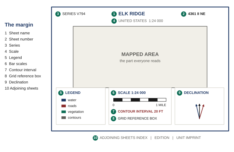
Figure 1 Everything outside the mapped area is the sheet describing itself: what it covers, at what scale, how the ground is drawn, and which north it uses. A map whose margin you have not read is a map you are guessing at.
The habit worth building is a fixed order, always the same five, always before you draw on anything. Identity, then scale, then contour interval, then declination, then legend. It takes under a minute once it is automatic.
Identity: which sheet, and how old
The sheet name is usually the most prominent settlement or feature, printed top center and repeated bottom left, and it is how you ask somebody for the right map. The sheet number is the reference used for indexing and ordering, and it is what actually identifies a sheet, because two sheets in different series can share a name. The series and scale tell you which family the sheet belongs to, and sheets in different series covering the same ground may use different conventions, different grids and different datums.
The edition and date are the item people skip and should not. Roads, tracks, buildings, treelines and watercourses all change. Contours and major landforms rarely do. An old sheet is still trustworthy for shape and untrustworthy for detail, and knowing which is which is the entire reason to read the date.
One more item earns a separate mention: the adjoining-sheets index, a small diagram usually at bottom right showing this sheet as a center square surrounded by its eight labeled neighbors. It answers the question you will actually have in the field, which is not what is on this map but which map covers the ground just past the edge of it. Anyone whose plans run near a sheet boundary should know the neighbors’ numbers before setting out.
Scale, and getting a distance off the sheet
Scale is printed two ways and both matter. The representative fraction is a ratio: 1:24,000 means one unit on the paper is 24,000 of the same units on the ground. It carries no units of its own, which is why it works in any measuring system.
The bar scales are the practical form, a set of printed rulers you lay your measurement against directly. Use them rather than doing arithmetic on the fraction. Paper stretches and shrinks with humidity, and a bar scale printed on the same sheet stretches with it. Arithmetic does not.
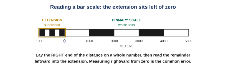
Figure 2 The section left of zero is the extension and it is subdivided; the section right of zero is not. Lay the right-hand end of your distance on a whole number first, then read the remainder leftward into the extension. Measuring rightward from zero and eyeballing the fraction is the error that produces answers wrong by part of a major division, every single time.
The other number governing how you read the ground is the contour interval, printed under the bar scales, which states the vertical distance between one contour line and the next. The same sheet redrawn at a different interval looks like different terrain: a twenty-foot interval on gentle ground gives usable detail, while a hundred-foot interval on the same ground gives you a nearly blank sheet with a few lines on it.
The declination diagram
Near the bottom of the sheet sits a small diagram with two or three arrows springing from a common point. It is the most consequential item in the margin and the one most often skipped, because it looks like decoration.
What it states is that there are three different norths and they do not agree. Grid north is the direction the map’s vertical grid lines run. True north is the direction of the geographic pole. Magnetic north is where a compass needle actually points, and it is neither of the other two, and it moves from year to year.
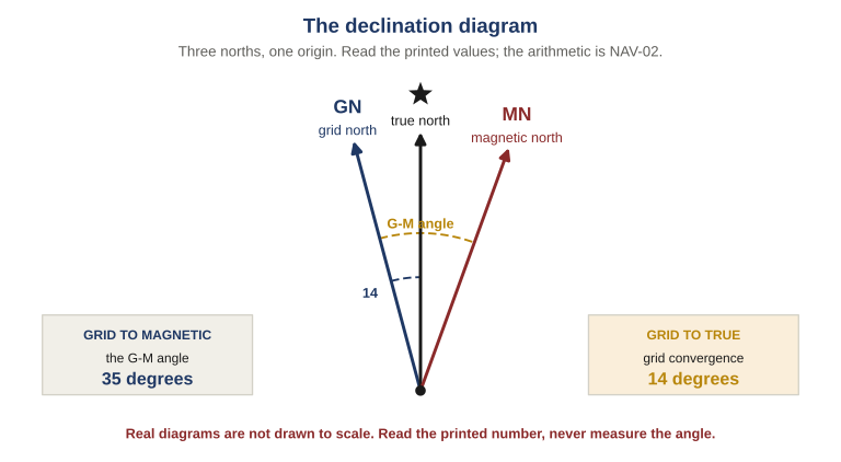
Figure 3 Three norths from one origin, with the angles between them stated as printed values. Read those numbers rather than measuring the drawing: the prongs are almost never to scale, and an angle protracted off the diagram will not be the angle on the sheet.
For grid work specifically, this matters for one narrow reason. Grid coordinates are built on grid north. Reading eastings and northings and plotting a point all happen inside the grid’s own frame of reference and are entirely unaffected by what a compass thinks. You need to find the diagram, note it, and know that the moment you pick up a compass the difference becomes arithmetic you cannot skip. That arithmetic is the subject of the companion article to this one, and it is drilled in NAV-02: Map and Compass Land Navigation.
The last margin item is the legend, which decodes the symbols, along with the color convention that goes with it: black for man-made features, blue for water, green for vegetation, brown for contours and relief, red or red-brown for major roads and survey information. The legend is the part of the margin most people do look at, and the part that matters least. A misread symbol is usually obvious and self-correcting. A wrong scale is not.
Contours, and the Check They Give You
Inside the mapped area, the entire third dimension of the landscape is carried by a set of thin brown lines most people learn to ignore. Learning to read them is usually sold as terrain appreciation. That undersells it. The real payoff is that contours are the only independent check you have on a grid reference somebody just handed you.
A contour is a line joining every point on the ground at the same height above sea level. That is the whole definition and everything else follows from it. Picture a hill standing in still water: the waterline traces a closed loop around it, every point on that loop at exactly the same height. Raise the water twenty feet and it traces a second, smaller loop higher up. Keep going and you have a set of nested loops. Draw those loops as seen from directly above and you have contours.
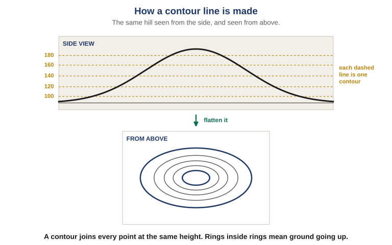
Figure 4 The same hill from the side and from above. Each height on the profile becomes a closed loop when seen from overhead. Rings nested inside rings mean ground going up, and the innermost ring is the summit.
Two rules fall straight out of the definition, and both are worth stating plainly because they are how you know you have misread something. Contours never cross, because a single point on the ground has one height; where they appear to cross on a real sheet they have merged into a cliff. Contours never simply stop, because every contour eventually closes on itself even if it takes several sheets to do it; a line that appears to end at the paper’s edge continues onto the adjoining sheet.
Spacing is slope
Once you accept that each line is a fixed height step, the horizontal distance between two lines tells you everything about steepness. Same vertical rise, less ground to cover it in, steeper slope.
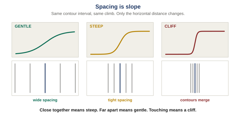
Figure 5 All three panels climb the same height. Only the distance taken to do it changes, and contour spacing records that directly. Wide spacing is ground you can walk up while talking; tight spacing is ground you will be using your hands on; lines converging to touching is a cliff.
This works at a glance and is the most immediately useful thing contours do. Two routes to the same point, one crossing four widely spaced lines and one crossing four bunched lines, are not the same walk, and the map told you so before you left.
Uniform spacing means a constant slope. Spacing that tightens as you climb means a convex slope, where a person at the bottom cannot see the summit and a person at the top cannot see the base. Spacing that widens as you climb means a concave slope, where the whole face is visible from either end. That difference decides whether you can be observed crossing a piece of ground.
The eight shapes
Every landform you will meet is one of eight shapes or a combination of them. Five are called major features and three minor, though the distinction is about size rather than importance.
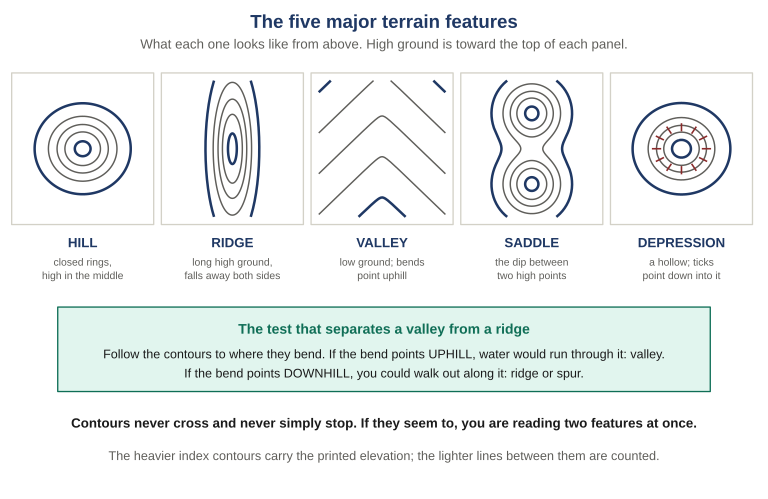
Figure 6 The five major features from above. Hill and depression look alike at a glance, since both are closed rings, and the tick marks pointing inward are the only thing separating them. The test that does most of the work in practice is to follow the contours to where they bend and read which way the bend points.
- Hill. Ground higher than everything around it. Closed rings getting smaller toward the middle, summit inside the innermost ring.
- Ridge. A line of high ground falling away on both sides but staying high along its length. Stand on it and you go down in two directions and stay level in a third.
- Valley. Low ground between higher ground, usually carrying water or the dry bed of it. Contours form U or V shapes and the bends point uphill.
- Saddle. The dip between two areas of higher ground, drawn as an hourglass or figure-eight with high ground at both ends. Not a low point overall.
- Depression. A hollow with higher ground all round it, drawn as closed rings exactly like a hill and distinguished only by short tick marks on the inside of the lines, pointing downhill into the hollow.
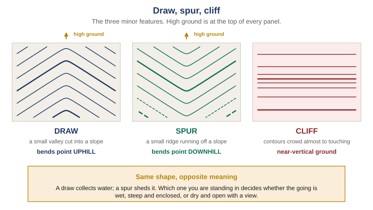
Figure 7 The three minor features. Draw and spur are the pair that gets confused, and they are the same shape read in opposite directions. A draw collects water and a spur sheds it, so one is wet, enclosed and steep-sided and the other is dry, open and exposed to view.
- Draw. A small valley cut into the side of a slope, often with no permanent watercourse. Contour bends point uphill. Water would collect here.
- Spur. A short ridge running out from the side of a larger hill. Contour bends point downhill, away from the high ground. Water runs off both sides.
- Cliff. Ground so steep it is effectively vertical. Contours crowd until they touch or merge into a single heavy line. Treat as impassable until proven otherwise.
Terrain association: reading the ground back
So far this has run one way, from paper to picture. The skill that matters most runs the other way. Terrain association means looking at the ground in front of you, looking at the map, and asking whether the two describe the same place. You are standing in a shallow wet gully with high ground rising on both sides. The map, at the grid you were given, shows a rounded summit. Those cannot both be right.
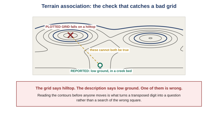
Figure 8 A grid arrives, gets plotted, and lands on a hilltop, while the person who sent it described standing in a creek bed. The contradiction is visible in seconds to anyone who reads the contours before acting, and invisible to anyone who does not.
This works because terrain is redundant and a grid is not. A grid is a bare string of digits with no internal check: change one digit and you get another perfectly valid grid. The description that comes with it, low ground, a saddle, the near side of a spur, is independent information, and two independent sources agreeing is evidence in a way that one source repeated is not.
When a grid arrives, plot it, then look at what it landed on and say the terrain out loud: that is a saddle between two summits. Compare that against whatever the sender told you. When they match, you have two agreeing sources. When they do not, you have found a problem while it is still cheap. This costs about five seconds and it is the single highest-value habit in map work.
Contour reading is the one topic here that will not stick from reading about it. NAV-01 Lesson 03 walks it as a drill on your own sheet: find one of each of the eight shapes, mark them, then go and stand at one and check the ground agrees with what you read.
Anatomy of a Grid Reference
Most people meet a grid reference as an undifferentiated string of characters, something like 17S HK 4783 9412, and copy it down without knowing which part does what. That works until a part goes missing, at which point it fails silently, because a grid with a piece missing is still a perfectly valid-looking grid.
A full military grid reference is built from three components, read left to right, each narrowing the ground the reference could possibly mean. The structure is deliberate: you can stop early and still have a usable, honest reference, provided everyone knows where you stopped.
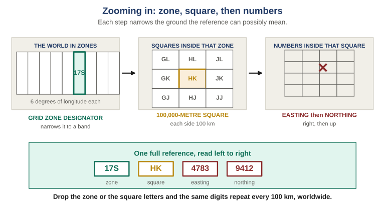
Figure 9 Each step narrows the ground the reference can possibly mean. The zone gets you to a band of the earth, the two letters get you to one 100-kilometer square inside it, and the digits get you to a point inside that square. Drop the zone or the letters and the digits stop being unique.
| Component | What it does | What happens if it is dropped |
|---|---|---|
| 17S Grid Zone Designator |
A number and a letter. The number is one of sixty north-south zones, each six degrees of longitude wide, counted eastward. The letter is a latitude band. Together they narrow the world to a rectangle a few hundred kilometers across. | The reference could be in any of sixty zones. Usually recoverable from context, occasionally not. |
| HK 100,000-meter square identifier |
Two letters naming one square, a hundred kilometers on a side, inside that zone. The first letter counts eastward, the second northward. This is the part left off most often and it matters most. | The digits now repeat every 100 kilometers in every direction, and nothing in the reference says which square was meant. |
| 4783 9412 Easting and northing |
The numeric part, always an even number of digits, split exactly in half. The first half is the easting, measured rightward from the square’s west edge; the second is the northing, measured upward from its south edge. | Mis-split or partly dropped, you get a valid grid somewhere else entirely, with nothing to signal the error. |
The phrase worth committing is zone, square, then numbers. Said in that order, out loud, every time, a missing component becomes audible. A reference that starts with digits is a reference with two parts missing.
Why the digit count is always even
The numeric part always has an even count, because it is two numbers of equal length written together with no separator. Four digits is two and two. Eight digits is four and four. There is no such thing as a seven-digit grid.
That gives you a free error check that costs nothing. Count the digits you were given, and if the count is odd, a digit was dropped or added somewhere between the sender’s mouth and your paper. You know that before you plot anything. What you cannot know is which digit, so the reference has to be requested again rather than repaired by guesswork.
Reading a grid aloud
Say it in its parts, with a pause between them, using the phonetic alphabet for the letters. One Seven Sierra, Hotel Kilo, four seven eight three, nine four one two.
Do not say forty-seven eighty-three. Grouped numbers get heard as other groupings, and the person writing it down has no way to detect the mistake. Digit by digit is slower to say and faster overall, because it is right the first time.
Three things a grid does not carry
It carries no elevation. A grid on the side of a steep slope says nothing about how far up that slope the point sits, and on genuinely steep ground the difference can be substantial. Contours supply that.
It carries no datum. The same digits plotted against a different reference model land somewhere else, often a couple of hundred meters away. More on this below.
It carries no time. A grid records where something was when it was observed. For anything that moves, the reference is perishable, and how quickly depends entirely on what you were looking at.
Precision Is a Promise
The numeric part can be four, six, eight or ten digits. Each step adds one digit to the easting and one to the northing, and each step shrinks the square you are claiming by a factor of ten.
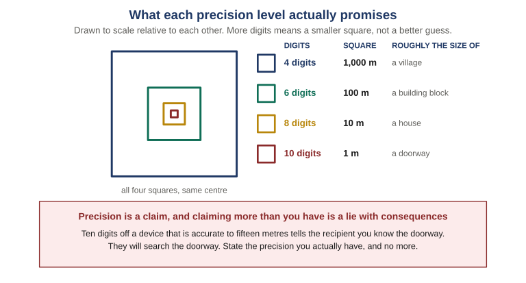
Figure 10 The four precision levels drawn to true relative scale. More digits does not mean a better guess. It means a smaller square, and a correspondingly larger promise about how well you know where you are. The ten-digit square is barely visible at this scale, which is exactly the point.
| Digits | Square | Honest use |
|---|---|---|
| Four | 1,000 m | An area, not a place. Reporting a general location, a named feature, or where something was last seen at distance. Useful precisely because it is modest. |
| Six | 100 m | The everyday working level. A building, a road junction, a small clearing. Enough to send somebody to the right place without implying you can point at a door. |
| Eight | 10 m | The standard for reporting a position somebody has to reach. Achievable with a coordinate scale on paper, and roughly the useful limit of a consumer receiver in good conditions. |
| Ten | 1 m | Rarely honest in the field. Survey work and precisely known fixed points. A device reporting ten digits is reporting its arithmetic, not its accuracy. |
Two facts about that table matter more than the rest. First, the digit count is a claim you are making to the recipient and they will act on it: given ten digits a person will look for a doorway, and given four they will search a field. Second, precision and accuracy are different things. A device can hand you ten digits that are precisely wrong, because the digits describe how finely the number is expressed rather than how close it is to the truth.
State the precision you actually have, and no more. If your receiver reports accuracy of fifteen meters, an eight-digit grid is already at the edge of honest and a ten-digit grid is a fabrication in a convincing format. Rounding down costs you nothing that matters. Rounding up sends somebody to search a square you never actually identified, and they will search it thoroughly, because you told them to.
Read Right, Then Up
Grid lines run two ways. The vertical lines, numbered along the top and bottom margins, measure eastward, and those numbers are eastings. The horizontal lines, numbered up the sides, measure northward, and those are northings. Every grid reference gives the easting first and the northing second, always, without exception.
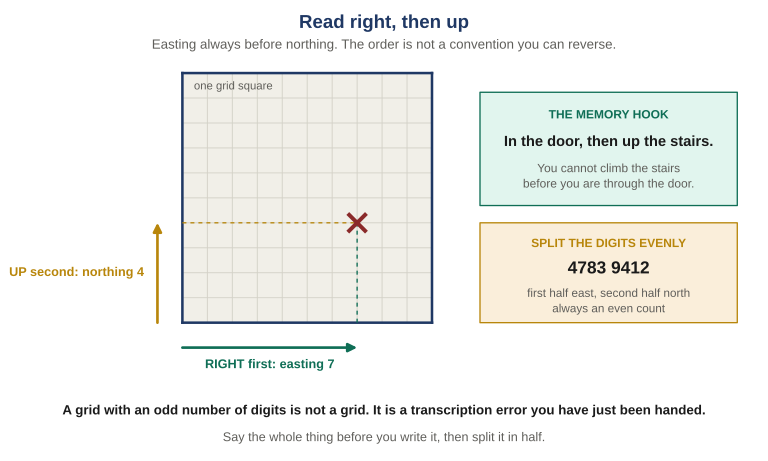
Figure 11 Right first, then up. The two dashed lines locate the point, and the order they are read in is fixed. The digits that come out get split exactly in half, first half easting, second half northing, which is why the count is always even and why an odd count means something was lost.
The standard mnemonic is in the door, then up the stairs. You cannot climb the stairs before you get through the door. It sounds childish and it survives stress, which is the only property a mnemonic needs.
Reversing the order is the single most common error in grid work, and it is nasty because a transposed reference is still a valid reference. Give the northing first and you have named a real place, plotted confidently, usually kilometers from where you meant.
Extracting a grid from the map
Find the point, then find the grid square containing it. A grid square is named by the lines to its left and below it, never the ones above or right. That alone gives you a four-digit grid.
For more precision you seat a coordinate scale into the square’s lower-left corner: horizontal edge along the grid line below the point, vertical edge touching the line to the left, then slide right until the vertical edge passes through the point. Both edges must stay in contact with their lines throughout. Read the value along the horizontal edge and append it to the easting; read the value along the vertical edge and append it to the northing. Then assemble the whole thing in order, out loud: zone, square identifier, easting, northing.
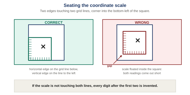
Figure 12 Correct seating on the left, the common failure on the right. A scale floated inside the square rather than seated into its corner reads short on both axes, by exactly the size of the gap you left. Nothing about the resulting grid looks wrong.
A coordinate scale is cut for one map scale and is wrong on every other. A 1:24,000 scale read against a 1:50,000 sheet produces a confident, well-formed, wrong answer rather than an obviously broken one. Check the scale printed on the tool against the scale printed in your sheet’s margin before you use it. Every time, until it is automatic.
Working without a coordinate scale
If you have no scale you can still work, and the discipline is knowing exactly what that costs. Most people can reliably estimate tenths of a distance the size of a grid square: halves and quarters confidently, tenths approximately. That gets you an honest six-digit grid resolving to a hundred meters.
What it does not get you is eight digits. Estimating hundredths by eye is not a skill anybody has, and per the precision rule above, that guess would be transmitted as a claim somebody acts on. Interpolating by eye and reporting six digits is good practice. Interpolating by eye and reporting eight is exactly the false-precision failure.
Buy one cut for your map’s scale, or print one. MapTools is the specialist supplier, and their tools came out of ground search and rescue work in the United States rather than out of a catalog. The one field that has to match is map scale, so start there.
- Stock tools listed by scale — the right entry point. Find your sheet’s scale, buy the tool cut for it.
- UTM, MGRS and USNG tools — the corner readers and grid overlays for the system this article works in.
- Free PDF tools — printable grids, roamers, rulers, scale bars, area estimators and compass roses. Copyrighted, but copying is permitted on a not-for-profit basis, so cost is not a reason to skip this.
- Custom rulers for any scale — for the sheet whose scale nothing stock matches.
However you get one, print or copy onto clear transparency film, then do the step people skip: lay the finished tool against your map’s own bar scale and confirm it came out the right size. Printers rescale silently, and a tool that printed at ninety-seven percent is worse than no tool at all, because it produces answers that look right. Two practical notes from MapTools’ own guidance, both learned the hard way: toner-based printers and copiers produce overlays whose toner scratches off, and laminating the film protects the image. Fortune Favors the Prepared has no affiliation with MapTools and earns nothing from these links.
Extraction and plotting are the two operations everything else rests on, and they are the part of this article you cannot learn in a chair. NAV-01 Lesson 05 is worked with the map open in front of you, including the step most people never try: doing it outside, in the dark, under a red light, which is the condition the skill actually has to survive.
The Three Errors
Nearly every misplotted grid traces back to one of three causes. All three produce a grid that looks perfectly correct, and none of them is detectable by inspecting the reference itself.
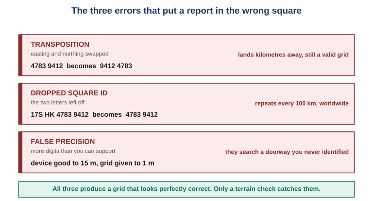
Figure 13 All three produce a grid that looks perfectly correct. None is detectable from the reference alone, which is why the terrain check is the only thing standing between an error and a search of the wrong ground.
| Error | What it looks like | Prevention |
|---|---|---|
| Transposition | Easting and northing swapped, or two digits reversed inside one of them. Produces a valid grid, usually kilometers from the intended point. | Say it in halves out loud, easting first, northing second, and have it read back the same way. |
| Dropped square identifier | The two letters left off because both parties are on the same sheet and it has never mattered before. The digits then repeat every hundred kilometers. | Zone, square, then numbers. Say all three parts every time, including when it feels unnecessary. |
| False precision | More digits than the method supports: eight digits off an eyeball estimate, or ten off a device reporting fifteen-meter accuracy. | Ask what produced the last two digits. If the answer is arithmetic rather than measurement, drop them. |
Notice that the prevention column is entirely procedural. There is no clever inspection that catches these, no checksum in the reference, no format validation that helps. The defense is habit, and habit only gets built by using the system for routine traffic on ordinary days.
When the Device Is Confidently Wrong
A handheld receiver or a phone will give you a grid faster and usually more accurately than you can extract one by hand. None of what follows is an argument against using one. A receiver will fix your position faster, more accurately and in worse conditions than you can manage with paper, in darkness, in fog, and in featureless terrain where there is nothing to associate with. That is a real capability and it is worth having.
The narrower argument is this: a navigator with one method cannot audit that method. Everything above is what lets you catch a device on the day it is confidently wrong.
Two settings before anything else
Every receiver and every mapping application has these two settings, usually together on a screen called something like Position Format, Units, or Coordinate System. They are the whole of the setup, and both must match your paper.
| Setting | What to set it to | Symptom of getting it wrong |
|---|---|---|
| Position format | MGRS, or UTM if MGRS is not offered. Many devices ship set to latitude and longitude in degrees and decimal minutes, which is a perfectly good format and not the one your group standardized on. | Numbers that look nothing like a grid, or a grid with no letters in front of it. Obvious and self-correcting. |
| Map datum | Whatever datum is printed in your sheet’s margin. Most modern sheets and most devices default to WGS 84, and if both say WGS 84 you are done. Older sheets often do not. | Nothing at all. The grid looks perfect and lands in the wrong place. |
Datum: the same numbers, different ground
A datum is the mathematical model of the earth’s shape that a coordinate is measured against. Different surveys, made in different eras for different regions, used different models, so the same physical point gets different coordinates depending on which model you express it in.
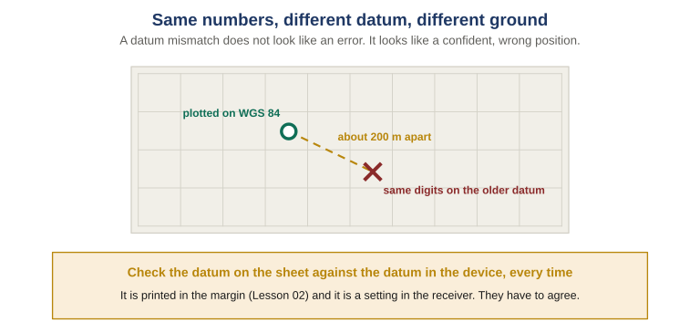
Figure 14 One set of digits, two datums, roughly two hundred meters between them. Nothing about the reference changes, so nothing warns you. Two hundred meters is the difference between the right building and the next field, and it is entirely silent.
The rule is simply that the two must agree: whatever the sheet says, the device says. If your sheet predates the 1990s there is a fair chance it uses a regional datum rather than WGS 84, and the offset in your area may be tens of meters or a few hundred. It is worth finding out once, for your own ground, rather than discovering it during something that matters.
Datum mismatch is the failure that scales badly. One person with a wrong datum makes one bad plot. A pre-positioned map series on one datum, handed to arriving mutual aid whose devices default to another, makes every plot wrong by the same amount in the same direction for the duration of the incident, and the internal consistency is exactly what stops anyone noticing. Document the datum on the map, in the communications annex, and in the deployment in-brief, and have arriving personnel verify position format and datum before they go operational.
The check before you transmit
Four seconds, every time, before a device-derived grid leaves your mouth or your keyboard.
- Does it match the ground? Plot it, or look at where the device places you on its own map, and say the terrain out loud. A grid claiming you are on a ridge while you stand in a stream bed is wrong regardless of how many satellites it is using.
- Is it complete? Zone, square, then digits. Devices often display the numeric part prominently and the letters in small type above it, and the letters are the part people fail to read out.
- Is the precision honest? Check the accuracy figure the device reports, then choose a digit count that figure supports. A screen showing ten digits is not an instruction to transmit ten.
- Has it been read back? Same rule as any other grid passed by voice. The device does not remove the transcription step at the receiving end.
If you want the layer underneath this, covering what the constellations actually are, how receivers use them, and every other setting on a handheld, that is the subject of our reference article on GNSS and handheld GPS setup.
Reports, Overlays, and the Card
A grid on its own is rarely the message. It sits inside something: a sighting passed to the rest of the group, a request for help, a note of where a cache is. The report is the vehicle and the grid is the part that makes it actionable.
Reporting formats vary between organizations and between purposes, but almost all of them contain a slot for where. In the SALUTE format, Size, Activity, Location, Unit, Time, Equipment, it is the third element, and the acronym exists because under stress people reliably forget one of the six.
What is worth noticing is that doctrinal examples of these reports frequently give the location as a named feature: a group seen crossing a road junction on a named ridge. That is reasonable when everyone involved shares a map with those names printed on it and has been briefed off the same overlay. It is also exactly the reference class this article opened by taking apart. The named ridge works for the people who were at the brief and fails for everyone else.
The rule worth adding is simple: the location line carries a grid, and any name is additional rather than instead. Grid first, then the name, is strictly better than either half alone. The grid is actionable by a stranger; the name is a terrain check the receiver can run immediately.
Precision follows purpose
| What the report is for | What precision serves it |
|---|---|
| Something was seen | Four or six digits. The receiver needs to know roughly where, and often the thing has moved by the time anyone acts. Eight digits on a moving subject claims a precision that expired while you were speaking. |
| Meet me here | Six or eight. The receiver has to arrive at a place and will be looking around when they get close. Six is usually enough in open ground, eight where the feature is small or the light is bad. |
| Come to this exact spot | Eight, with a terrain description alongside. Somebody hurt, a cache, a specific gate. This is where the extra two digits genuinely change the outcome, and where a description matters most because it lets the receiver confirm on arrival. |
| A fixed point, recorded once | Eight, measured carefully, written down. A rally point or a water source is measured at leisure and read out for years, so the effort belongs at the recording stage rather than the reporting stage. |
The pattern behind the table is that precision should track what the receiver will do with it, not how much precision your instrument happens to display.
The confirmation loop
A grid passed by voice is not complete until it has been read back and confirmed. Three steps, and none of them is optional. The sender transmits in parts, phonetically for the letters and digit by digit for the numbers, pausing between components. The receiving station reads back the whole reference from what they wrote down, not from their memory of what they heard, because reading back from memory tests the ear while reading back from paper tests the paper, and the paper is what will be acted on. Then the sender explicitly confirms or corrects and asks for another readback. Silence is not confirmation.
Until that loop closes, both parties should treat the grid as unconfirmed and nobody should be moving on it. This is the test that landmarks fail, and it works here only because the reference is the kind of thing an error is audible in. A wrong digit sounds wrong. A wrong landmark sounds fine.
When a grid is not enough: the overlay
Some things cannot be said in a location line: the shape of a treeline, where a track has washed out, what a position can and cannot see, how three positions relate to each other. These want a drawing, and a drawing is only useful if the receiver can put it on their own map in exactly the right place.
An overlay is a sheet of transparent material laid over the map, carrying only the additional detail and no map features. Lifted off, it is a set of marks floating in space. What makes it usable is registration.
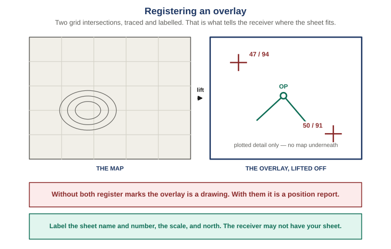
Figure 15 Trace the grid intersections nearest two opposite corners and label each with its coordinates. Those two marks are what let a receiver lay your sheet onto their own copy in exactly one position. Without them the overlay is a drawing; with them it is a position report that happens to be drawn.
Trace two intersections at opposite corners, not adjacent ones, because two marks close together fix position but leave rotation ambiguous. Label each with its easting and northing, which are four-digit values naming the lines themselves rather than a point within a square. Then add an identity block: sheet name and number, scale, and a north arrow, because the receiver may not be holding the same sheet and needs to know what to go and find.
One register mark fixes where the overlay sits but lets it rotate about that point, and a sheet rotated a few degrees puts detail at the far end tens or hundreds of meters out. Two marks at opposite corners fix position and rotation together, and the further apart they are the smaller the residual error.
The card that makes it real
Everything above concerns a single grid at a time. The thing almost nobody has is the set of places their household and their group already depend on, written down in a form somebody else could act on.
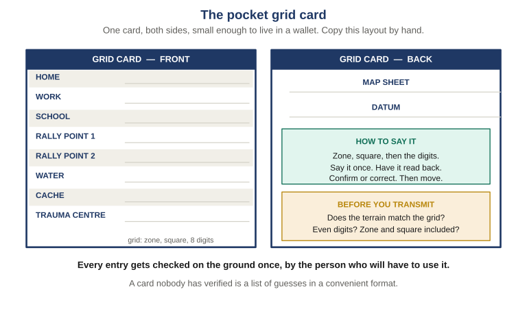
Figure 16 The card, both sides. The front is the list. The back carries the two things a grid is useless without, which sheet and which datum it was taken from, plus the reading procedure, because the person using this card in an emergency may be the least practiced member of the household.
Start with the places already in your plan under a name. Home. Work. Each school. The rally points. Water. Caches. The nearest trauma center, which is not necessarily the nearest hospital.
Then add the ones nobody writes down because everyone assumes they are obvious: the gate you would actually drive out of, the place on the property where a vehicle can turn around, the corner of the field a helicopter could use, the neighbor’s house with the working generator. These are exactly the landmarks this article opened with, and this is where they get converted from personal references into ones a stranger can act on.
Choose precision per entry rather than filling the column. A rally point in open country is a six-digit place. A specific gate in a hedgerow at night is eight. Write the card by hand, on card stock or laminated paper, not on a phone. The whole premise is that it works when the phone does not. And put it somewhere it will be found by somebody who is not you, then tell them it is there, because a card in a drawer nobody knows about is a card that does not exist.
An unverified card is a list of guesses in a convenient format, and it is more dangerous than no card at all because it will be trusted. Plot each entry back fresh and confirm it lands where you meant, since extracting and plotting are different operations and an error in one does not reproduce in the other. Terrain-check each entry against what you know is there. Walk one, ideally not your house, and confirm you are standing where the card says. And hand the card to the least practiced person in your household and ask them to read an entry aloud, listening for whether they include the letters and whether they group the digits. That last one is the real test. A card only the author can use has not solved the problem this article opened with.
Building and verifying the card is NAV-01 Lesson 08, the final lesson, and it closes a loop the course opens on day one: you write down where you are in Lesson 01, in your own words, and write it again at the end to see what changed.
The Bottom Line
Here is a test worth doing before you close this page. Write down where you are right now, exactly as you would say it to somebody who has to come and find you. Not a description of the building, but instructions a person could act on, written the way you would actually say it out loud, in a hurry, to somebody you know.
Then ask three questions of what you wrote. Could a stranger act on it, holding a map, unable to ask a follow-up? Could you say it over a bad radio link, and would a readback reveal an error? How precisely does it locate you, and would the reader know that, or have to guess?
Most first attempts fail all three, and they fail for the reason the man on the radio failed. The reference depended on the reader already knowing your ground. A grid does not depend on the reader knowing anything except how to read a grid, which is a thing you can teach somebody in an afternoon. That is the whole difference between a personal reference and a shared one, and it is why the group agrees on a system before it needs one.
Nothing in this article requires equipment you do not already have. It requires a paper sheet of your own ground, a coordinate scale that matches it, a pencil, and the habit of reading the margin before the middle and the terrain before the digits. The eleven minutes are not spent on the radio. They are spent, or saved, months earlier, on an ordinary afternoon, by somebody who wrote a card and had their least practiced family member read it back.
This article is the reference layer. The training that goes with it is NAV-01: Grid Coordinates and Map Reading, an eight-lesson course that works this material with your own map, your own ground and your own device, with graded knowledge checks, field exercises and a printable companion guide.
NAV-01 answers where is it. Its companion course, NAV-02: Map and Compass Land Navigation, answers the other half of the question, which is how to get there without a battery. The reference layer for that half is Three Norths, the companion article to this one.