Skip to content

Fortune Favors the Prepared

Semper Paratus, Semper Gumby

Menu
  • The Continuity Chronicles
    • THE RANCH
    • Inside the Meadow
      • LONG LINES
    • GlobalTec – Company Profile
      • GlobalTec Network
    • 3C’s COMMUNICATIONS
    • Alex’s Demolition & Construction
    • McAllister Outfitting
    • High Country Air
    • Pikie’s Perfect Cast
  • Daily Threat Reports
        • DAILY THREAT REPORT
        • DAILY THREAT REPORT – LITE
        • DAILY PREPAREDNESS BRIEF
        • Acronym & Abbreviations Glossary
        • DTR Source Registry
        • Area-Specific Assessment Report
        • COMMS WATCH
        • THE HOUSEHOLD BRIEF
        • FLASH REPORTS
        • SOFT TARGET SECURITY BRIEF
        • FINANCE SECTOR
        • HEALTHCARE SECTOR
        • TRANSPORTATION & LOGISTICS SECTOR
        • AI, DATA CENTER & INFRASTRUCTURE REPORT
        • CONSTRUCTION & MANUFACTURING SECTOR
        • Strategic Intelligence Supplement
  • About
        • The Why
        • Vision and Mission
        • Services
          • Business Resiliency
        • Testimonials
        • Insider
        • Friends
          • Patriot Volunteer Examiner (VE) Team
          • Angery American
          • Signal Stuff
          • Forward Observer
  • Communications
        • Stump Knocker
          • SOI
          • STUMP KNOCKER DMR UPDATES
          • MMDVM Hotspot
        • Preparedness Communications
          • What Radio Should I Get for Preparedness?
            • What Radio to Buy?
              • What Radio to Buy? – video
              • Ham Radio on a Budget
              • Live – What Radio to Buy?
              • Portable Radio Kit
              • Mobile Communications
          • Emergency Communications Principles
          • Communications Options
          • Starter Radio Paths by Preparedness Scenario
          • How Communications Fail
          • HF Communications
            • SHTF HF Communications
            • Simple Antenna Builds for HF – video
            • NVIS in Amateur Radio
        • Amateur (HAM) Radio
          • Why Do I Need a Ham License?
            • How to Obtain Your Amateur Radio License
              • Amateur Radio Learning Resources
              • Finding a Ham Exam
                • HAM Exam Accommodation
              • Getting Into Ham Radio – Video
            • Are You Expired?
            • Why You Should Upgrade to a General Ham License
          • HAM Simplex Frequency Card
          • Analog versus Digital
          • Analog vs Digital Voice: A Preparedness-Focused Comparison
          • CTCSS and DCS
          • Programming Radios with Software
          • ARES, RACES, ACS and AUXCOMM
          • Ham Radio Beyond Line-of-Sight
            • Linked Analog Repeaters
            • EchoLink and IRLP
            • AllStarLink
            • Yaesu System Fusion & WIRES-X
            • D-STAR
            • Digital Mobile Radio (DMR)
            • P25 in Amateur Radio
            • NXDN in Amateur Radio
            • Amateur Radio Satellites (AMSAT)
            • The 60-Meter Band (5 MHz)
          • Meshtastic
          • HAM VoIP
        • Personal Radio Services
          • FCC Rules for Personal Radio Services
          • Family Radio Service (FRS)
          • General Mobile Radio Service (GMRS)
            • GMRS Repeaters
            • Getting a GMRS License
            • FRS / GMRS / MURS Frequency Card
          • Multi-Use Radio Service (MURS)
          • Citizen Band (CB) Radio
            • CB Frequency Card
        • Other Radio Services
          • Communications Continuity Programs and Capabilities
          • Marine Communications
        • Cell Sites and Their Services
          • When Cell Service Fails
          • Radio over LTE and Rapid Radios
            • LTE Radio Comparison
        • Satellite Communications
          • America’s Secret Eyes
          • The Commercial Eye
          • Seeing Through Everything (SAR)
            • Remote Area Emergency Communication Devices
            • Which Beacon Should You Carry?
          • Personal Satellite Communications
        • Wired Communications
          • MAG Phone System
          • TA-312/PT Field Telephone and SB-22/PT Switchboard
          • Understanding Telephone Wiring
          • The AT&T Long Lines Program
        • Communications Planning
          • Communications Plan Annex
            • Communications P.A.C.E.
            • Finding Information for Your Communications Plan
            • Area-Specific Assessment Report
          • Automatic Link Establishment (ALE)
          • Understanding Communications Resiliency
        • Communications Resiliency Programs
          • ARES, RACES and ACS
          • Auxiliary Communications (AUXCOMM)
          • Military Auxiliary Radio System (MARS)
          • U.S. Coast Guard Auxiliary Communications
          • Civil Air Patrol Communications
          • The 60-Meter Band (5 MHz)
            • Understanding the 60-Meter Band
        • Government Communications Continuity Programs
          • Government Emergency Telecommunications Service (GETS) and Wireless Priority Service (WPS)
          • National Warning System (NAWAS)
          • National Interoperable Frequencies
          • The FEMA National Net (FNARS)
          • National Emergency Communications Network (NECN)
          • The SHARES Program
          • State Emergency Capability Using Radio Effectively (Operation SECURE)
          • The High Frequency Global Communications System (HFGCS)
          • Satellite Mutual Aid Radio Talkgroup (SMART)
          • The AT&T Long Lines Program
        • Communications & Emissions Discipline
          • Communications Security (COMSEC)
            • Book Cipher
            • One Time Pads (OTP)
              • Decrypting One Time Pad Message
              • One Time Pads (OTP) Live Video
              • One Time Pad Training
          • Cryptographic Security (CRYPTOSEC)
          • Transmission Security (TRANSEC)
          • Communications Transmission Discipline (TRANSDISC)
          • Emissions Control (EMCON)
          • Communications & Emissions Training Framework
        • DMR Programming
          • DMR Programming – Talk Groups
          • DMR Programming - Roaming
          • MMDVM and Yaesu System Fusion (YSF)
          • Encryption in DMR Radios
        • Digital Mobile Radio (DMR) Networks
          • WR3IRS Interstate DMR Network
            • South Central PA (SC PA)
            • North East PA (NE PA)
            • Washington-Baltimore (W-B)
            • West Central Florida (WCF)
          • Florida Digital Amateur Radio Network (F-DARN)
          • Southeast Florida DMR Repeater Network W2GGI
          • Virginia DMR (DMRVA)
          • NC PRN DMR Network
          • SC Hospital Emergency Amateur Radio Team (SCHEART)
          • HEARS – Hospital Emergency Amateur Radio System
          • New England Digital Emergency Communications Network (NEDECN)
        • Baofeng/BTECH Radios Quick Guide
          • Manually Programming a Baofeng Radio – Video
          • A User’s User Manual for Baofeng Radios
        • MESSAGES & REPORTS
          • Phonetics
          • Procedure Words (Prowords)
          • Date Time Group (DTG)
          • NTS Radiogram Form
            • ARL Numbered Radiograms
          • SALUTE, SPOT, and SALT Reports
          • ACE/LACE Reports
          • GOTWA Report
          • CASREP (Casualty Report) Format
          • MEDEVAC Request Report
          • Formatted Messages (downloads)
        • Communications Knowledge Library
          • Communications Resiliency
          • Radio Etiquette, Jargon, and Best Practices
          • AmRRON RESOURCES & REFERENCES
          • Anytone Programmable Keys
          • Phonetics
          • Amateur Radio Colorado
            • Colorado Linked Repeater Systems
        • COMMUNICATIONS REFERENCES
  • Planning
        • Family Emergency Plan – The Basics
          • Family Emergency Plan
          • Why Every Family Needs an Emergency Plan
        • Family Contingency Binder
          • Family Contingency Binder MindMap
        • Triggers
          • Preparedness Conditions – PREP-CON
            • Preparedness Conditions (PREP-CON) MindMap
          • Space Weather
        • Family Emergency Plan Workbook
          • Family Emergency Plan Workbook - owner resources
            • Area-Specific Assessment Report
            • Family Emergency Planning Form
            • Communications Plan
              • P.A.C.E.
            • Emergency Evacuation
            • Emergency Food Supplies
            • Family Contingency Binder
            • Message Drops
            • Get Home Bag
            • Bug Out Bag & Bins
            • Miscellaneous
        • Next of Kin Workbook
        • METT-TC: Decision Discipline
          • METT-TC - tactical planning
        • Planning Your Preps
          • Charity in Planning
        • Mutual Assistance Group
          • Mutual Assistance Groups (MAGs): Skills, Vetting, and Building Real Resilience
          • Mutual Assistance Group (MAG): Recruitment Code of Conduct
          • MAG: Private Vetting & Intake Process
          • Compartmentalization in Mutual Assistance Groups (MAGs)
          • Resiliency Index
          • Continuity of Government & Application to MAGs
  • Threat Assessment
        • Personal Preparedness Assessment Workbook
          • Personal Preparedness Assessment Report
          • Personal Preparedness Assessment Workbook - owner resources
        • Readiness Conditions for Preparedness
          • PREP-CON - Preparedness Conditions
          • COMCON – Communications Readiness Condition
          • CONCON – Civilian Continuity Conditions
        • Readiness Conditions – Hierarchy and Relationships
          • LERTCON – Alert Condition
          • DEFCON – Defense Readiness Condition
          • COGCON - Continuity of Government
          • INFOCON – Information Operations Condition
          • FPCON – Force Protection Condition
          • EMERCON – Emergency Condition
          • CYBERCON – Cyber Readiness Conditions
          • CPCON – Cyberspace Protection Condition
          • WATCHCON – Watch Condition
          • SIPRNet – Secret Internet Protocol Router Network
          • REDCON – Readiness Condition
          • NC3CON – Nuclear Command, Control, and Communications
        • Readiness Conditions in The Conspiracy Chronicles
          • CERCON – Cerberus Readiness Condition
          • COMCON – Communications Readiness Condition
          • C-OPS – CERBERUS Operational Status Conditions
          • CONCON – Civilian Continuity Conditions
        • Being Prepared for Civil Unrest
          • Civil Unrest – Area Intelligence
          • Civil Unrest – Be Prepared
          • Civil Unrest – Defense
          • Civil Unrest – Defense (part 2)
        • Staying Informed Before, During and After Emergencies
          • Weather Awareness
          • Space Weather
        • Area Intelligence
          • Area-Specific Assessment Report
        • National Power Grid
  • Intelligence
        • Community Intelligence
          • Area Intelligence – Now!
            • Area-Specific Assessment Report
          • Community SITREP
          • Radio Traffic Situational Analysis During Emergencies
            • Radio Traffic Situational Analysis (RTSA) -TRAINING CURRICULUM
        • Operations Security (OPSEC)
          • OPSEC for Teens
          • OPSEC for Kids
          • The Gray Man
          • OPSEC: Don't Become the Target
          • Counterintelligence Tradecraft for the Prepared
        • Intelligence Gathering & Analysis
          • Signals Intelligence (SIGINT) – the basics (2020)
          • Signals Intelligence – Information Gathering Basics (2022)
          • Signals Intelligence (SIGINT)
            • Communications Intelligence (COMINT)
              • Short Wave Scanning
              • Communications Continuity Programs and Capabilities
              • Staying Informed Before, During and After Emergencies
              • Integrated Public Alert and Warning System (IPAWS)
            • Electronic Intelligence (ELINT)
            • Tactical Electronic Intelligence (TACELINT)
          • Open-Source Intelligence (OSINT)
            • How to Conduct a Daily Threat Analysis Using OSINT
          • Measurement and Signature Intelligence (MASINT)
          • Overhead Imagery & Geospatial Intelligence (IMINT / GEOINT)
            • America’s Secret Eyes
            • Seeing Through Everything (SAR)
              • Which Beacon Should You Carry?
          • Technical & Infrastructure Intelligence (TECHINT)
          • Electronic Surveillance (ES)
          • Electronic Counter-Surveillance
          • The Five Eyes Satellite Intelligence Network
          • SALUTE, SPOT, and SALT Reports
        • Understanding Intelligence Analysis Tools
          • Understanding Analysis of Competing Hypotheses (ACH)
            • ANALYSIS OF COMPETING HYPOTHESES (ACH) - TRAINING CURRICULUM
          • Understanding MDCOA
          • Understanding OAKOC
        • INTELLIGENCE REFERENCES
  • Medical
        • Medical Training
          • Patient Assessment & Casualty Management
            • MARCH-PAWS Rapid Assessment
              • MARCH-PAWS TRAINING CURRICULUM
            • DCAP-BTLS – Secondary Trauma Assessment
            • SAMPLE + OPQRST Secondary Assessment
              • Medical History as a Preparedness Skill
                • Medical History as a Preparedness Skill – TRAINING CURRICULUM
            • START Triage
            • MEDEVAC Request Report
            • Patient Assessment – Documentation
              • Patient Care Report Forms
              • CASREP (Casualty Report) Format
        • Medical Kits
          • Individual First Aid Kit (IFAK)
          • BooBoo and IFAK Kits Video
          • BooBoo & IFAK Kit Mind Map
          • Large Kit - video
        • Medical Myths
          • Medical Myths – Tampons
          • Medical Myths – Ingested Poisoning
        • MEDICAL REFERENCES
  • Transportation
    • Transportation Plan B
    • Improvised Transportation
    • Preparedness For Winter Travel
  • Animals
    • Preparedness for Pets
  • Food
        • Why You Should Start a Food Storage Plan
        • Food Storage Quick Start
        • Buying in Bulk
        • Inventory Tracking
        • FOOD PRESERVATION RESOURCES
  • Water
  • Power
        • Power Grid
        • UPS
  • Bags etc.
        • Bug Out versus Get Home Bags
        • Get Home Bag – Contents
          • Get Home Bag – video
          • Get Home and Bug Out Bags - video from live 2-10
  • Navigation & Signalling
        • Sketched Strip Map
        • Emergency Signaling
        • Covert Signals
        • Which Emergency Beacon Should You Carry?
  • References
        • PLANNING & OPERATIONS
        • SECURITY OPERATIONS
        • INTELLIGENCE
        • CRYPTOLOGY
        • COMMUNICATIONS
        • REPORTING FORMATS
        • GENERAL/MISC
        • MEDICAL
        • FOOD PRESERVATION
        • CRITICAL INFRASTRUCTURE
        • SURVIVAL MANUALS
        • OPSEC
        • COUNTER INSURGENCY & CIVIL DISTURBANCE
        • EMP / CME
        • Training
          • Training Videos
          • One Time Pad (OTP) Exercises
            • 45662
            • 222135ZDEC22
  • Blog
    • Boomer
      • Day 1 – The Journey Home
      • Day 2 – First Day in the New Home
      • Day 3 – More Training
      • Day 4 – Dad Goes Back to Work
      • Day 5 – A Day at Home with More Training with Dad (Boomer’s version)
      • Day 6 – More Training with Dad at Home
      • Day 7 – Dad Goes Back to Work, Boring Day
    • Mountain Readiness Fallout Workshops
    • Mapping DMR Repeaters
    • COMMUNICATIONS RESILIENCY
    • Getting The Message Through
    • What are you preparing for?
    • Never Let an Opportunity Go To Waste
    • Consequences
    • DO NOT REPLY
    • Space Weather Warning
    • Good, and Sad, News
    • Necessity vs. Luxury
    • Don’t Put off Until Tomorrow
    • No Plan Survives First Contact
    • Threat and Hazard Identification and Risk Assessment (THIRA)
    • Live – What Radio to Buy?
    • Big Daddy Unlimited Affiliate
    • Food – Tue 16th 7pm MST
    • Live from 2021-2-3
    • Live 2021-01-26
    • FLASH SALE
    • Live 2021-01-11
    • What Is Freedom?
    • Preparedness for Pets
    • What If The Lights Go Out?
    • Hoarding or Prepping?
    • Why Do I Need a Ham License?
    • How Bad is the SolarWinds Orion Issue?
    • How To Begin Prepping
    • Members Only Live Videos
    • Live 11/24
    • Ham Radio VoIP Phone
    • Training Calendar
    • A Chat (with some whisky)
    • Blog 2020 11 02
    • Live with Charlie Hogwood
    • EARTH EX 2020
    • A Live with Angery American
    • Have You Woken Up Yet?
    • BUG OUT READY
    • The Gray Man
    • Area Intelligence – Now!
    • Being Prepared for Civil Unrest
    • It Depends
    • The Art of Being Prepared – The New Prepper
    • Get Home versus Bug Out Bags
    • Why You Need an IFAK AND Training
  • Shop
  • Contact
    • Mailing List
  • Media and Press
Menu

NVIS in Amateur Radio

A Practical Guide to High-Angle HF Communication


This article references parts of the story in my fiction books, The Meadow Protocol (book 1), The Brush (part 2), and in book 3 (still being written) part of The Continuity Chronicles series. Available in my store for signed paperback and hard copies or from Amazon to include Kindle and Audible.


Near Vertical Incidence Skywave (NVIS) is an HF operating technique that deliberately launches RF energy almost straight up (roughly 60–90° elevation). The signal reflects from the ionosphere and returns to Earth nearby — typically covering the region that normal long-distance HF signals skip over.

Instead of chasing DX, NVIS is about reliable regional communication, which makes it especially valuable for:

  • Emergency communications
  • Disaster response
  • Preparedness (“prepper”) networks
  • Regional coordination nets
  • Terrain-challenged areas

In simple terms:

NVIS turns HF into a regional communications tool instead of a long-distance one.


What NVIS Actually Does

NVIS works by combining:

  • High radiation angles
  • Lower HF bands
  • Low horizontal antennas

Typical coverage:

  • 0–300 miles (0–500 km) depending on ionospheric conditions and band selection.

Because signals go almost straight up and come back down:

  • Mountains and terrain matter less
  • Coverage is more uniform
  • Skip zones are minimized
  • Infrastructure isn’t required

This is why military and emergency communicators have historically relied on NVIS concepts when regional reliability matters most.


1️⃣ Height Is the Key Variable

The most important NVIS principle:

Lower is better.

Typical NVIS height is:

  • 0.05–0.25 wavelength above ground

Practical examples:

BandTypical NVIS Height
80 m10–20 ft
60 m10–15 ft
40 m8–12 ft

At these low heights, ground interaction reshapes the pattern upward, creating strong high-angle radiation.


2️⃣ Best Antenna Types for NVIS

Low Horizontal Dipole (Gold Standard)

  • Predictable pattern
  • Efficient
  • Excellent high-angle energy
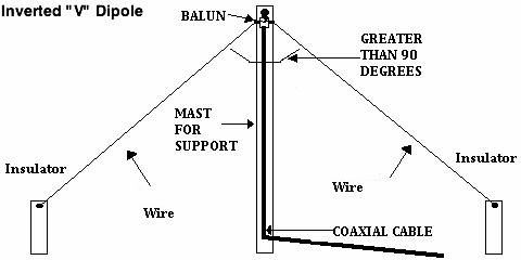
Inverted-V

  • Easy field deployment
  • Requires only one high support
  • Nearly identical NVIS performance

Horizontal Loop

  • Multiband flexibility
  • Broad regional coverage

Fan Dipole

  • Multiple bands for day/night switching
  • Popular with emergency operators

3️⃣ Advanced Option: Reflectors

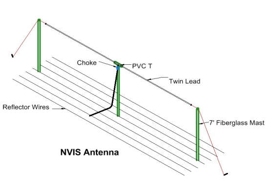
Some advanced NVIS designs add a reflector wire beneath the primary antenna (slightly longer element). This improves upward radiation and can increase efficiency on 40–80 m bands.

Elevation angle directly controls where your signal lands:

Elevation AngleTypical Result
5–20°DX / long haul
20–40°Medium distance
60–90°NVIS regional coverage

A simple change in antenna height dramatically changes performance:

  • Low antenna → high angle → regional coverage
  • High antenna → low angle → long-distance DX

Same antenna — different mission.


Band Selection for NVIS

The ionosphere determines which bands work.

General patterns:

  • Daytime: 40 m (sometimes 60 m)
  • Night: 80 m or 160 m
  • High solar activity: higher bands may work temporarily

The upper limit is controlled by the ionospheric critical frequency — above that, the signal passes through space instead of reflecting.

Experienced operators frequently change bands as conditions shift.


NVIS vs Other Antenna Designs

NVIS vs Vertical Antennas

Verticals:

  • Low-angle radiation
  • Excellent DX
  • Poor regional fill-in

NVIS requires high-angle radiation, so verticals usually underperform for regional emergency work.


NVIS vs High Dipoles

A dipole:

  • ½ wavelength high → DX machine
  • ⅛ wavelength high → NVIS regional coverage

Height changes the mission profile completely.


NVIS vs Beams / Yagis

Beams excel at:

  • Gain
  • Directionality
  • Long-distance links

But for regional coordination:

  • NVIS often works better because coverage is area-based, not directional.

Real-World Advantages of NVIS

✔ Works without repeaters
✔ Effective in rugged terrain
✔ Simple wire antennas
✔ Reliable regional coverage
✔ Minimal infrastructure required


Limitations (Important)

NVIS isn’t magic:

  • Frequency selection matters
  • Day/night band shifts required
  • Not all bands support NVIS all day
  • Both stations benefit from NVIS-optimized antennas

Example Field Deployment

A proven configuration:

  • 40 m dipole
  • Center at ~10 ft
  • Ends at 6–8 ft
  • Coax feed + balun
  • Optional fan dipole for 80 m

This setup provides excellent regional consistency with minimal setup time.


Emergency, Disaster & Preparedness Doctrine Applications

Why NVIS Fits Emergency Communications Doctrine

Modern emergency management doctrine emphasizes:

  • Interoperability
  • Regional coordination
  • Redundant systems
  • Infrastructure independence

Frameworks like the Federal Emergency Management Agency Incident Management guidance emphasize clear communications and compatibility between responding agencies.

The problem in real disasters:

VHF/UHF repeaters may fail — and long-distance HF skips over the exact area that needs coverage.

NVIS fills that gap.


The Regional Communications Bubble

NVIS creates a regional “umbrella” that can connect:

  • Emergency Operations Centers (EOCs)
  • Shelters
  • Hospitals
  • Logistics hubs
  • Field teams

Because propagation returns nearly vertically, terrain becomes much less of a barrier.


Alignment With Real HF Emergency Systems

Programs like the SHARES High Frequency Radio Program use HF radio principles to maintain communications during infrastructure outages.

Doctrine similarities:

GoalNVIS Benefit
Interagency coordinationRegional coverage
Infrastructure independenceSimple wire antennas
ReliabilityConsistent propagation
SurvivabilityWorks without networks

Amateur Emergency Communications

Volunteer organizations such as Amateur Radio Emergency Service train operators to deploy portable HF stations quickly using simple antennas and independent power — exactly where NVIS shines.


Disaster Scenarios Where NVIS Wins

✔ Natural Disasters

Hurricanes, ice storms, fires, earthquakes:

  • Repeaters down
  • Cell overloaded
  • Internet disrupted

NVIS keeps regional coordination alive.

✔ Large Infrastructure Failure

Power outages or cyber disruptions:

  • HF becomes a communications backbone
  • Low-power field stations remain effective

✔ Mountainous Terrain

Vertical return paths reduce terrain shadowing.


Prepper Communications Doctrine

A common preparedness mistake:

Designing for long-distance DX instead of local coordination.

In reality, most scenarios prioritize:

  1. Family/team communications
  2. Local intelligence sharing
  3. Regional resource coordination
  4. Mutual aid connectivity

NVIS supports all four.

Prepper NVIS Philosophy

  • Low antennas = good
  • Simple wires beat complexity
  • Reliability beats range

A 10-foot wire often outperforms expensive systems when regional coverage is the objective.


Operational Architecture (Doctrine Model)

A practical layered structure:

Local tactical → VHF/UHF
Regional coordination → NVIS HF
External/long haul → Higher HF or relays

This layered approach mirrors incident communications planning concepts used in national response frameworks.


Why NVIS Beats DX-Focused Antennas During Disasters

AntennaDisaster Performance
VerticalGood DX, poor regional
High dipoleSkips local area
Beam/YagiDirectional, infrastructure-heavy
Low NVIS dipoleReliable regional coverage

In emergencies:

You rarely need 2,000 miles — you need 100–300 miles.


Field Best Practices

Professional and preparedness operators often follow these rules:

  • Pre-cut and label antenna wires
  • Practice fast deployment
  • Use plain language (no codes)
  • Train day/night band switching
  • Test under battery/field power

Simple systems survive better.


The Big Picture: NVIS as a Communications Doctrine

NVIS is more than an antenna trick — it’s a strategy for resilient regional communication.

It provides:

  • Infrastructure independence
  • Reliable regional coverage
  • Terrain tolerance
  • Rapid field deployment
  • Operational simplicity

When the goal is dependable communication across a state or region — especially under stress or during disasters — NVIS frequently outperforms antennas designed for maximum distance.


Military NVIS — Purpose-Built for Tactical Communications

While amateurs often discover NVIS through experimentation, military forces designed systems specifically for NVIS decades ago because it solves a persistent battlefield problem:

How do you maintain reliable communications across a region when terrain, mobility, and destroyed infrastructure make line-of-sight and repeater systems unreliable?

Military HF doctrine answers that with high-angle skywave — the exact principle behind NVIS.


1️⃣ The Classic Military NVIS Antenna — AS-2259/GR

One of the best-known military NVIS designs is the AS-2259/GR antenna.

Its design philosophy is very different from typical amateur dipoles:

Core design features

  • Crossed sloping dipoles arranged at right angles
  • Elements double as guy wires
  • Horizontal + vertical polarization components
  • Very rapid deployment
  • Designed for 0–300 mile regional circuits

The antenna system was specifically intended to create high-angle radiation for short-range skywave links.


Why crossed dipoles?

Military planners needed:

  • Reliable signal regardless of station orientation
  • Compatibility with varied terrain
  • Reduced sensitivity to polarization mismatch

Crossing two sloping dipoles produces a more uniform regional footprint — ideal for tactical networks where units may move or rapidly redeploy.


2️⃣ Tactical Design Requirements Behind Military NVIS

Military NVIS antennas are designed around operational constraints, not maximum gain.

Typical design priorities include:

Military RequirementResulting NVIS Feature
Rapid setupTwo-person, tool-less erection
MobilityLightweight mast sections
Omnidirectional coverageCrossed dipoles
Regional reliabilityHigh takeoff angles
Equipment compatibilityBroadband HF operation

The AS-2259, for example, could be erected by two operators in only a few minutes — critical for tactical operations.


3️⃣ Frequency and Range Doctrine

Military NVIS systems typically operate in:

  • 2–10 MHz most consistently for NVIS use
  • Up to 30 MHz depending on ionospheric conditions

Operational goal:

Reliable regional communication rather than maximum distance.

Typical military planning assumes:

  • 0–300 mile coverage
  • Command-and-control inside a maneuver area
  • Backup when VHF/UHF LOS networks fail

This matches what amateur operators experience during emergency nets.


4️⃣ Modern Military Evolutions

Later field manuals show a shift toward lighter broadband inverted-V systems while keeping the same NVIS principle.

Example design concepts include:

  • Broadband inverted-V HF antennas
  • Lightweight NVIS kits paired with manpack radios
  • Antennas optimized for HF skywave 0–500 mile coverage

The doctrine did not change — only materials and portability improved.


5️⃣ Why Military NVIS Looks “Low and Messy”

Many amateurs are surprised when they first see a military NVIS installation:

  • Low height
  • Sloping wires
  • Compact footprint

This is intentional.

Military engineering assumes:

  • High visibility = risk
  • Tall structures = vulnerability
  • Setup speed matters more than perfection

The result:

Low-profile antennas that prioritize reliability and survivability over gain.


6️⃣ Military NVIS vs Amateur NVIS — Same Physics, Different Objectives

Amateur ApproachMilitary Approach
ExperimentationStandardized doctrine
Maximize performanceMaximize reliability
Fixed installations commonRapid deployment required
Optimized for a single operatorDesigned for teams

Despite differences, the electromagnetic principle is identical:

Low horizontal antennas create high-angle radiation.


7️⃣ Tactical Lessons Amateur Operators Can Apply

Military NVIS design teaches several practical lessons:

✔ Height control matters more than complexity
✔ Omni regional coverage beats directional gain in emergencies
✔ Low antennas are easier to deploy and conceal
✔ Simple wire systems are often best

Many emergency-communications amateurs unknowingly mirror military HF doctrine when they deploy low dipoles or inverted-V NVIS antennas.


8️⃣ Military NVIS Doctrine — The Big Concept

Military communication planning uses layered systems:

Local tactical → VHF/UHF
Regional command → NVIS HF
Long range / theater → satellite or long-haul HF

NVIS fills the critical middle layer — the same layer most disaster and preparedness operators need.


9️⃣ Key Takeaway

Military forces did not adopt NVIS because it was interesting — they adopted it because it is predictable, repeatable, and dependable under stress.

That same reliability is why NVIS remains one of the most practical HF strategies for:

  • Emergency management
  • Disaster response
  • Preparedness networks
  • Regional amateur radio coordination

Fortune Favors the Prepared

Semper Paratus, Semper Gumby

Login with Patreon

Login with Patreon

Search Site

Products

  • The Continuity Chronicles Seal Decal The Continuity Chronicles Seal Decal $5.00 Original price was: $5.00.$3.00Current price is: $3.00.
  • Family Emergency Plan Workbook - Patreon Family Emergency Plan Workbook - Patreon $19.95
  • Personal Preparedness Assessment Workbook - Patreon Personal Preparedness Assessment Workbook - Patreon $19.95
  • The Next of Kin Workbook - Patreon The Next of Kin Workbook - Patreon $23.95
  • Personal Preparedness Assessment Report Personal Preparedness Assessment Report $179.95
  • Family Emergency Plan + Next of Kin Workbooks Family Emergency Plan + Next of Kin Workbooks $59.95 Original price was: $59.95.$49.95Current price is: $49.95.
  • The Next of Kin Workbook The Next of Kin Workbook $29.95
  • ASAR — 50 Mile Radius ASAR — 50 Mile Radius $139.95
  • ASAR 50-MILE + FAMILY EMERGENCY PLAN WORKBOOK ASAR 50-MILE + FAMILY EMERGENCY PLAN WORKBOOK $169.95
  • ASAR — 50 Mile Radius - Patreon ASAR — 50 Mile Radius - Patreon $39.95
  • THE COMPLETE LIBRARY BUNDLE THE COMPLETE LIBRARY BUNDLE $109.38 Original price was: $109.38.$85.00Current price is: $85.00.
  • THE SERIES STARTER BUNDLE THE SERIES STARTER BUNDLE $29.98 Original price was: $29.98.$22.49Current price is: $22.49.

Cart

©2026 Fortune Favors the Prepared | Built using WordPress and Responsive Blogily theme by Superb