Updated: 2026 05 17
Weather is the threat most likely to affect you this year. Tornadoes give little to no notice. Hurricanes give days. Flash floods give minutes. The action stack is the same across all of them: know the difference between a watch and a warning, get the alerts on more than one channel, understand the codes, train, and validate before you need it.
This article walks that stack. It is the threat-assessment side of weather preparedness. The planning side — your shelter location, your evacuation route, your family communications plan, your supply stack — lives in the FFTP workbooks linked throughout.
Watch vs Warning: know the difference
This is the single most common public misunderstanding in weather safety. A watch and a warning are not severity levels on a sliding scale. They mark different points in the timeline of a hazard, and they demand different actions.
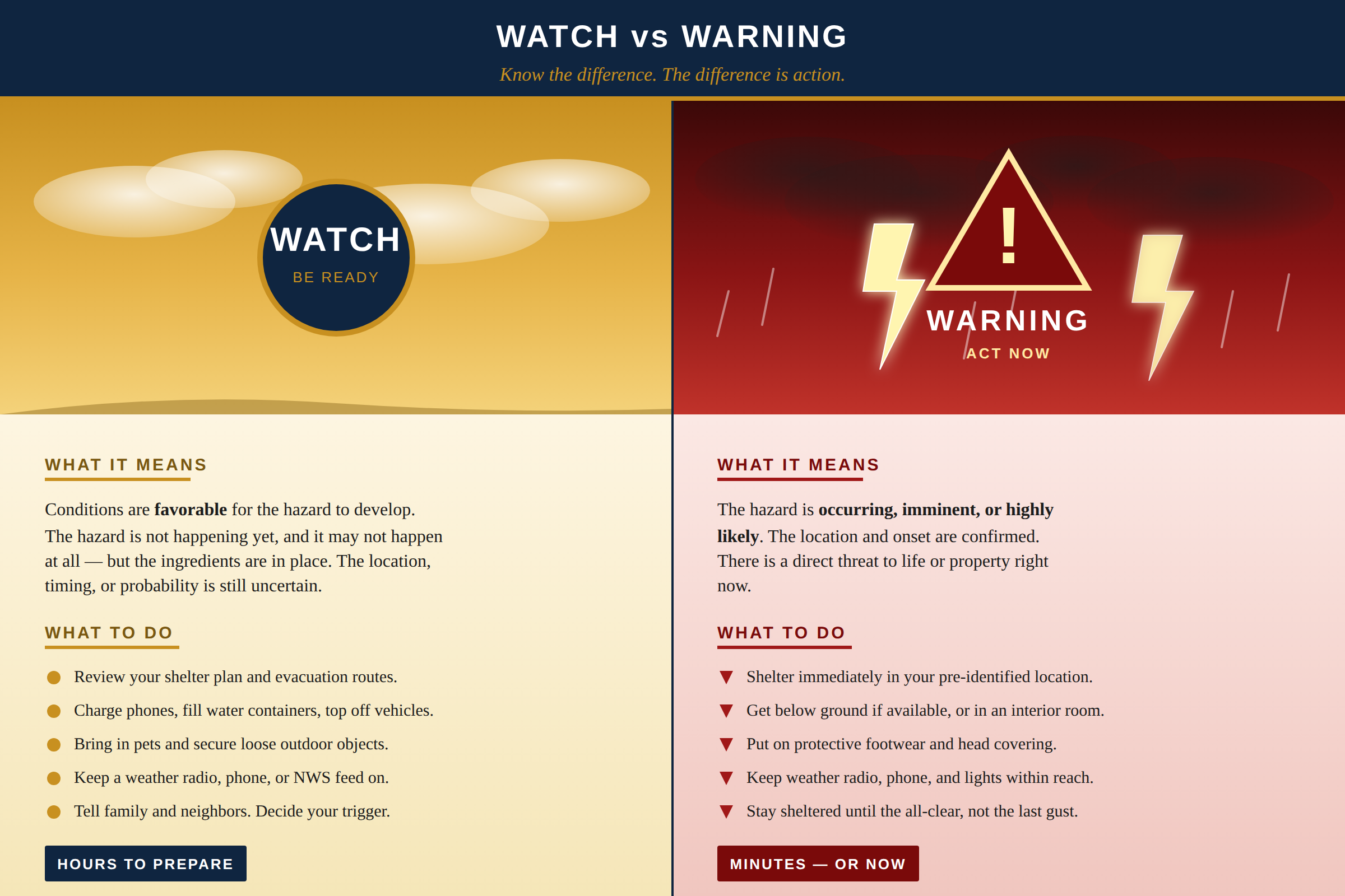
If you take one thing from this page, take this: a watch is the cue to get ready. A warning is the cue to act. The watch buys you the time the warning will not. Use it.
The four-letter code convention. Every alert event has a three-letter EAS/SAME code. The last letter tells you what kind of message it is: W for Warning, A for Watch, E for Emergency, S for Statement. Tornado Warning (TOR), Severe Thunderstorm Warning (SVR), and Evacuation Immediate (EVI) are legacy codes that predate the convention but follow the same logic. The complete list is on our SAME and event codes page.
Have a plan before the watch issues
A watch only buys you time if you already know what to do with it. The Family Emergency Plan (FEP) Workbook is built to be filled in once and pulled out when you need it.
- Shelter-in-place location identified, communicated, and rehearsed with every member of the family.
- Evacuation routes (primary and alternate) with rally points and out-of-area contact.
- Communications plan with PACE-layered options, frequencies, and message drops.
- Bug Out and Get Home bag inventories with refresh schedule.
- Emergency food, water, and contingency binder structure.
Your weather P.A.C.E.
No single channel for weather information is reliable on its own. Cell networks fail. Power fails. NOAA transmitters have coverage gaps. Local sirens are designed for outdoor use, not to wake you indoors at night. The answer is a layered P.A.C.E. — Primary, Alternate, Contingency, Emergency — for how you receive hazardous weather information.
| Layer | Channel | Why it sits here |
|---|---|---|
| Primary | NOAA Weather Radio with SAME programming | Direct from NWS, county-filtered, will wake you at 3 a.m. when nothing else can. Independent of cell network and internet. Battery backup keeps it alive through the power outage that follows the storm. |
| Alternate | Wireless Emergency Alerts (WEA) + the NWS mobile app | WEA is the cellular broadcast layer for tornado, flash flood, hurricane, and AMBER alerts. On by default for most categories. The NWS app provides the full text and tracks the event over time. Both depend on cell service. |
| Contingency | Local AM/FM broadcast + amateur radio SKYWARN or weather net | EAS messages move through commercial broadcast stations faster than the NOAA voice cycle in many areas. SKYWARN nets give you eyes-on-ground reports from trained spotters in your county. Pick a local repeater that runs a regular weather net and program it into your scanner or HT. |
| Emergency | Outdoor sirens, visual observation, neighbor relay | If the other three layers are down or you are caught outside, this is what is left. Sirens are activated only for warnings, never watches, and are intended for people who are outdoors. Train yourself to read sky and wind. Have a runner plan if cell service is out and family is at different locations. |
The Primary and Alternate layers should be running automatically every day. The Contingency and Emergency layers exist for the day the first two go dark.
NOAA Weather Radio: the primary channel
NOAA Weather Radio (NWR) is the National Weather Service’s direct-to-public broadcast network. Around 450 transmitters cover most of the United States, broadcasting forecasts, observations, and hazardous-weather alerts 24 hours a day on seven VHF frequencies between 162.400 and 162.550 MHz.
NOAA Weather Radio Frequencies
All frequencies in MHz. Use the strongest signal you can receive. The NWS station listing at weather.gov/nwr/station_listing tells you which transmitter covers your address and on which frequency.
The two features that matter most
Not every weather radio is equal. The two features that separate a useful radio from a noisy nuisance are SAME filtering and event code selection:
- Specific Area Message Encoding (SAME) tags every alert with a 6-digit county code. A SAME-programmed radio stays silent unless the alert is for one of your programmed counties. Without SAME, your radio alerts on every watch and warning anywhere within the transmitter footprint — often a dozen counties or more. Within a few weeks, most people turn the radio off. Defeats the purpose.
- Event code selection lets you turn individual event types on or off. For example, suppress flash flood statements during routine rainy seasons while keeping tornado warnings and severe thunderstorm warnings active. Some events (Tornado Warning, Severe Thunderstorm Warning, Evacuation Immediate, Emergency Action Notification) cannot be disabled and shouldn’t be.
See the comparison chart. We’ve built a comparison covering the 14 most-recommended weather radios, including which ones support SAME, how many county codes they hold, whether they allow per-event filtering, and what use case each is best suited for. See the Weather Radio Comparison page.
Programming a SAME radio: three things you need
- Your NOAA transmitter frequency. Find it at weather.gov/nwr/station_listing or check the coverage map at weather.gov/nwr/Maps.
- Your 6-digit SAME county codes. Look them up at weather.gov/nwr/counties or call the automated hotline at 1-888-NWR-SAME. Program your home county, then any counties you regularly travel through.
- Your event-code selections. The default is “alert on everything.” Run with the defaults for the first month, then tighten the filter once you understand the alert mix in your area.
For the complete list of SAME and event codes, including the structure of the FIPS code and the FCC W/A/E/S naming convention, see the NOAA SAME and Event Codes Reference page.
Let the ASAR do the legwork for you
Looking up your home county is easy. Building the full picture of which counties you actually need to program — home, work, school, the route between them, the storm tracks that affect your area, the adjacent counties whose problems become your problems within an hour — is harder. That is exactly what the Area-Specific Assessment Report (ASAR) is built to deliver.
- Every county within your selected radius (50-mile, 100-mile, or custom) with its 6-digit SAME code already pulled.
- The NOAA Weather Radio transmitter(s) covering your area, the broadcast frequency for each, and the coverage footprint so you know which frequency to program.
- The local NWS Weather Forecast Office (WFO) responsible for your area, with contact channels and SKYWARN program information.
- The dominant weather hazards for your AOR — drawn from historical event data, not guesswork.
- Adjacent-county and upstream-watershed considerations so the codes you program reflect how weather actually moves into your area.
Wireless Emergency Alerts and the NWS app
WEA is the cellular broadcast layer for life-safety alerts. Your phone receives WEA messages from every cell tower in range without needing a data connection, a subscription, or any user setup. It is the alternate channel in your weather P.A.C.E. and the most likely path the warning will reach you if you are away from your weather radio.
Categories and settings
WEA carries five main categories: National Alerts (cannot be disabled), Imminent Threat Alerts (tornado warning, flash flood warning, hurricane warning, and so on), Public Safety Alerts, AMBER Alerts, and Test Alerts. On iOS the settings live under Settings » Notifications » Government Alerts. On Android they live under Settings » Safety & Emergency » Wireless emergency alerts. Verify all categories are on except Test Alerts (which you can toggle to taste).
The NWS app and weather.gov mobile
The official NWS web experience at weather.gov is mobile-optimized and pulls from the same NWS API that drives most quality third-party weather apps. For a hazard event, the NWS source gives you the full warning text, the polygon shape, expiration time, and the affected counties. Third-party apps are convenient but not all of them pull from NWS, and some prioritize ad revenue over alerting speed. Know which one you are using.
Internet-based radio and TV. If you stream music, listen to satellite radio, or watch streaming TV, you may never see the local EAS message that interrupts terrestrial broadcast. Build your weather P.A.C.E. assuming you will not be on a local channel when the alert fires.
SKYWARN and amateur radio
SKYWARN is the NWS volunteer storm-spotter program. Trained spotters report ground-truth observations — hail size, wind damage, funnel cloud sightings, flooding — back to their local Weather Forecast Office over amateur radio and other channels. Spotter reports are the input that often confirms or upgrades a warning, and they are often the first information available about what’s actually happening on the ground.
The official SKYWARN program page is at weather.gov/skywarn. Local NWS offices run training classes annually, usually in late winter before severe weather season. Most offer an online version for people who cannot attend in person.
If you have an amateur radio license, find the SKYWARN net and the weather net on a local repeater. RepeaterBook indexes weather nets by state. Many local NWS offices operate their own amateur radio station and accept spotter reports directly over the air.
Don’t have your license yet? You can still listen and learn from weather nets — listening requires no license. But you can’t transmit reports, and you can’t operate during the emergency when amateur radio carries more traffic than any other voluntary channel. See How to obtain your amateur radio license for the path. Technician class is enough to participate in most VHF/UHF nets.
Hazard-specific guidance
Tornadoes
Tornadoes give the least notice of any major weather hazard. A Tornado Watch may issue hours in advance; a Tornado Warning often gives only minutes. Action checklist:
- Identify your shelter location now, not when the warning sounds. Below-grade is best. Interior room, lowest floor, away from windows is next best. A bathtub or closet on the lowest floor of a manufactured home is not safe — get out of the manufactured home and into a sturdier structure or below grade.
- Wear shoes and a head covering (bike helmet, work helmet, even a heavy pot) while sheltering. Most tornado injuries are from flying and falling debris, not the wind itself.
- Stay sheltered until the all-clear is issued. The visual “it’s quieter now” cue is not the all-clear; tornadoes often travel in families with a brief lull between them.
- Practice the shelter run with every family member at least twice a year. If everyone in the household cannot get to shelter inside three minutes, you need a closer shelter or a faster route.
Flash floods
Flash flooding kills more people in the United States most years than tornadoes. The danger is twofold: the speed of onset (often less than an hour from the watch to fatal flooding), and the way moving water behaves around vehicles. Six inches of moving water can sweep a person off their feet; two feet of moving water can float most vehicles. The phrase is Turn Around, Don’t Drown, and it is non-negotiable.
- Never drive into water of unknown depth, even if you have seen others do it successfully. Road surfaces wash out from underneath; what looks like six inches over pavement may be three feet over an open culvert.
- If your vehicle stalls in floodwater, abandon it immediately and move to higher ground on foot.
- Know your flood zone. The FEMA Flood Map Service Center at msc.fema.gov shows the official flood hazard layers for your address.
- If you live in or near a flood zone, the recovery side of this hazard is its own undertaking. See the FFTP Household Recovery Workbook and the Disaster Debris guidance.
Hurricanes and tropical storms
Hurricanes are the rare hazard that gives days of notice. Use them. The first 48-72 hours of forecast track are your watch window — fuel vehicles, draw cash, top off water containers, secure outdoor objects, confirm shelter or evacuation decision, and pre-position your bug-out kit if evacuation is likely. Once the warning issues and conditions begin to deteriorate, your decision options collapse fast.
Inland flooding from rainfall, not coastal storm surge, causes most hurricane fatalities. A hurricane that weakens to a tropical depression can still drop 20 inches of rain over 48 hours hundreds of miles from the coast. Track the rainfall forecast as carefully as you track the wind forecast.
Winter weather
Winter storms are slower than convective hazards but kill through three different mechanisms: traffic accidents, hypothermia, and carbon monoxide poisoning from improvised heating during power outages. Your winter weather P.A.C.E. is the same as your severe weather P.A.C.E., but your action stack adds: keep generators outside and at least 20 feet from any window or vent; never use a gas stove or charcoal grill for heat; carry a vehicle winter kit if you drive in storm conditions; and have a non-electric heating option for your shelter location.
Know where your preparedness gaps are
Weather is just one threat vector. The Personal Preparedness Assessment (PPA) Workbook walks you through a structured self-assessment of your readiness across every domain — shelter, water, food, power, communications, medical, security, transportation, financial — and shows you where the gaps are so you can close them in priority order.
- Scored assessment across every preparedness domain, not just the ones you think of often.
- Surfaces blind spots in plans you thought were complete.
- Output is a prioritized to-do list, not just a report card.
- Repeatable annually so you can track progress year over year.
Personal weather stations and field instruments
A personal weather station gives you a level of redundancy if you rely on your phone or app for severe weather warnings. When cell towers go down, your station keeps recording. Most modern stations connect to home WiFi and feed both your phone and your home display.
Categories worth knowing:
- Simple indoor station with outdoor sensor. Gives you temperature, humidity, and barometric pressure trend. Low cost, low maintenance, good awareness baseline.
- Complete home station. Adds wind speed and direction, rain gauge, and often UV and solar radiation. Brands worth comparing include Davis Instruments, Ambient Weather, AcuRite, and Ecowitt.
- Lightning detector. Either an add-on to a home station or a standalone portable unit. Useful for outdoor work, sporting events, and pool operation. Most consumer units give you a 25-40 mile detection range.
- Handheld weather meter. Wind speed, temperature, humidity, sometimes barometric and density altitude. Kestrel makes the gold standard; Extech and others offer less expensive options. Long-range shooters and pilots already own one of these.
Specific model recommendations age quickly. The features matter more than the brand: outdoor-rated sensor housing, replaceable batteries in the outdoor unit, WiFi or LoRa link back to a base, and an app that does not require a paid subscription to access your own data.
Pre-season checklist
Run this list before each severe-weather season transition: late winter for spring tornado and flood season, late spring for summer convective and hurricane season, and early fall for winter storm season.
Before the season
- Weather radio: confirm Required Weekly Test is heard on the programmed frequency.
- SAME codes: verify home, work, school, and travel counties are still programmed.
- Event codes: review your event-code filter list against the past season’s experience.
- Batteries: replace alkaline backup batteries in every alerting device on a known date.
- WEA: confirm Imminent Threat, Public Safety, and AMBER alerts are enabled on every household phone.
- NWS app: installed, location set, notifications enabled, push permissions granted.
- Shelter: identified, accessible, and rehearsed in the dark by every household member.
- Family plan: out-of-area contact still valid, message drop locations confirmed, reunion plan understood.
- Vehicle: emergency kit refreshed, fuel kept above half tank during high-risk weeks.
- SKYWARN: refresher training scheduled if eligible.
Want it done for you?
The Personal Preparedness Assessment Report is the done-for-you version of the PPA workbook. We work through your situation with you, gather the inputs, and deliver a written assessment covering threats specific to your location, your gaps across every preparedness domain, and a prioritized roadmap to close them. The ASAR layers in for the threat side: every county and SAME code in your radius, your NOAA transmitter and frequency, your dominant local hazards drawn from historical event data, and the surrounding-area context that makes the assessment specific to where you actually live or operate.
Together they answer two questions at once: what is most likely to happen here, and where am I least prepared for it.
Remember, Fortune Favors the Prepared.