4. The decision rule
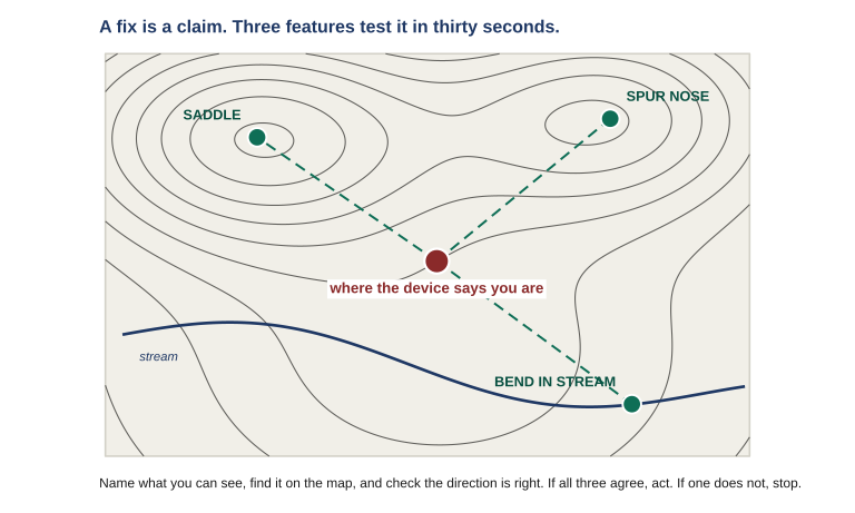
You have done the check and something does not fit. The map says the spur runs east and you are looking at it running north. This is the moment the course exists for, and it needs a rule decided in advance, because deciding it in the moment goes badly.
The rule
If the device and the ground disagree, you are lost until proven otherwise. Stop moving. Do not split the difference.
Not “probably a glitch.” Not “close enough, keep going and it will sort itself out.” Disagreement means one of your inputs is wrong and you do not yet know which, and every step taken in that condition makes the recovery longer.
Then work through the cheap explanations before the expensive ones, because most disagreements are a setting rather than a catastrophe:
FirstAre you looking at the right point?Navigating to the waypoint you think you are? A neighboring name on the list is the single most common cause.
→
SecondFormat and datumDoes the device match the sheet? An eighty-meter-class disagreement is this until proven otherwise.
→
ThirdIs the fix healthy?Accuracy figure, satellite view, position stable or jumping. Terrain and canopy from Lesson 01.
→
ThenRe-establish by terrainIf none of the above explains it, put the device away and fix your position from the ground. NAV-02 procedure.
Note what the last step does not say. It does not say average the two, or take the midpoint, or trust whichever feels closer. A disagreement is not noise to be smoothed; it is information that one source is wrong, and the resolution is to re-establish position by a method that does not depend on the source you now doubt.
There is one useful asymmetry to hold. The device is usually right about where a stored point is; the ground is authoritative about where you are. A coordinate somebody sent you does not become wrong because you cannot find the feature — but your own position most certainly can be, and that is the one to re-establish first.
5. Recognizing a bad fix before it costs you
Some disagreements announce themselves earlier if you know the tells. None of these is proof; each is a reason to look harder.
| What you notice |
What it suggests |
| Position jumps while you stand still, accuracy figure unchanged |
Reflected signals. Move to more open ground and take the fix again. |
| Accuracy figure climbing steadily as terrain closes in |
Restricted sky view. Expected, honest, and a reason to widen your tolerance rather than distrust the device. |
| Elevation disagrees with the map by more than the contour interval |
Elevation reference or an uncalibrated altimeter — and a hint the horizontal may be off too. |
| Bearing to a known feature is off by a consistent amount |
North reference or a stale manual declination, not a position error at all. |
| Everything looks perfect and the ground does not match |
Datum or format. This is the one with no other symptoms. |
That last row is the reason this lesson comes after Lesson 03 rather than before it. The most dangerous failure mode produces no tells whatsoever — and the only reason you would ever catch it is that you looked up.
6. Stepping down without stopping
When the resolution is that the device is not usable, the transition to map and compass should be a step rather than an event. That means the conditions for it were set up long before: the paper map is on you rather than in the vehicle, the route is marked on it, the grids are written down, and you know roughly where you have been since the last confirmed point.
If all of that is true, the transition costs you a pause at a known point and nothing else. If none of it is true, the transition is a crisis, and the difference was decided at the map table days earlier.
Lesson 09 covers the degraded and denied cases in detail — recognizing them, and moving through them without halting. The point here is narrower: the step down is not a failure of the plan, it is the plan. A member who moves to map and compass on a disagreement and turns out to have been wrong about the disagreement has lost twenty minutes. A member who presses on has lost their position and does not know it yet.
What to carry out of this lesson
- The ground is the authority, the map is the reference, the device is a proposal — the reverse of the order most people trust them in.
- Name three features you can see before you read the screen. Knowing what the fix claims makes you find the terrain it predicts.
- Plausible ground proves almost nothing. An eighty-meter error lands on terrain that looks entirely reasonable.
- If the device and the ground disagree, you are lost until proven otherwise. Stop moving, check the cheap explanations, and re-establish by terrain. Never split the difference.
Field Drill
On ground you know, with the map you would actually carry.
- Walk to three points and at each one run the four-step verification, out loud, in order — features first, screen second. Time it. Note whether you cheated and looked at the screen first.
- Deliberately induce a disagreement: change your device’s datum to a different one, then take a fix and plot it. Measure how far off it lands, and notice how ordinary the wrong point looks. Set the datum back and confirm you did.
- Have somebody put a waypoint in your device without telling you which point it is. Navigate to it, verifying at least once on the way. If the fix and the ground ever disagree, run the decision ladder rather than improvising.
- Write your own version of the decision rule in one sentence, in words you would actually use under pressure, and put it on the settings card from Lesson 03.
This drill is the rehearsal for the capstone in Lesson 10.