NAV-06 · Lesson 02
The Constellations Above You
Four governments, roughly 130 satellites, and two receiver capabilities that almost everyone confuses with each other.
Reading: about 15 minutes · Field drill: about 20 minutes
Lesson 01 treated the satellites as a single anonymous supply of timing signals. They are not. There are four independent global systems overhead, run by four governments who agree on very little else, plus regional systems that fill in over particular parts of the world. A receiver built in the last several years listens to all of them it can hear, at once.
Two separate receiver capabilities come out of this, and they get conflated constantly: how many systems your receiver listens to, and how many frequencies it listens on. They fix different problems, they cost different amounts of battery, and knowing which one you have is what makes the settings in Lesson 03 mean anything.
1. Why there is more than one system
The United States built GPS for the Department of Defense in the 1970s and opened it to civilian use in stages through the 1990s. Every other global system that followed exists for the same reason, and it is not a technical reason. A country whose military, banking timestamps, power grid synchronization, and emergency services all depend on a foreign navigation signal has handed control of its critical infrastructure to a government its citizens cannot vote out. Russia, the European Union, China, India, and Japan each reached that conclusion independently and built their own.
The civilian payoff is accidental but substantial. A receiver that can hear several systems sees more satellites at any given moment, fixes faster from cold, and holds a position under tree cover, between buildings, and at high latitude where any single system thins out. Of the roughly 130 active satellites across the four global systems, somewhere between 25 and 35 are above your horizon at any moment, and a receiver standing in the open will typically be tracking 15 to 25 of them.
| System | Operator | Active satellites | Worth knowing |
|---|---|---|---|
| GPS | United States | About 31, at 20,180 km | The reference standard. Fully operational since July 1995. Carries the L1 signal every receiver since the 1990s can hear, and the newer L5. |
| GLONASS | Russia | 24, at 19,130 km | Strongest at high latitude, which is why it appears in serious outdoor receivers far outside Russia. Alaska and northern Canada benefit most. |
| Galileo | European Union | About 28 launched, at 23,222 km | Built civilian from the start, with newer clocks. Deliberately shares frequencies with GPS so one antenna hears both. Carries a search-and-rescue relay. |
| BeiDou | China | 35, mixed orbits | The only system using a hybrid of medium, geostationary, and inclined orbits. Strongest over the Asia-Pacific. |
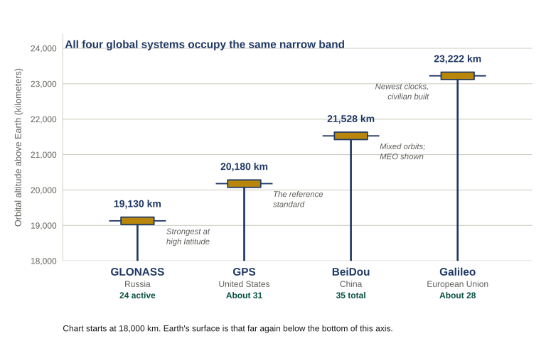
Figure 2.1 All four global systems sit inside a band about 4,000 kilometers deep, roughly 20,000 km up. They are peers rather than tiers, and none is inherently better placed than the others — what differs is constellation size, orbit design and clock generation. Earth’s surface is another 18,000 km below the bottom of the chart.
Two regional systems fill in rather than compete. Japan’s QZSS keeps a satellite nearly overhead the Japanese islands, which is exactly what a receiver needs in a dense urban canyon, and most receivers simply treat it as additional GPS satellites. India’s NavIC covers India and about 900 miles beyond, and as of early 2026 it is operating below design strength after a series of atomic clock failures dropped it to three working satellites. That last detail is a useful reminder: constellations are maintained infrastructure, and infrastructure degrades.
2. Two axes, not one
Before the distinction makes sense, correct one common picture. A multi-system receiver is not switching between systems, choosing GPS in one place and Galileo in another. It listens to everything it can hear simultaneously and treats each visible satellite as one more measurement feeding a single calculation. The arithmetic does not know or care which government launched a given satellite — only how precisely its signal can be measured and how well its orbit is known.
GLONASS
Galileo
BeiDou
→
Step 2CorrectRemove atmospheric delay — measured directly if two frequencies are available, estimated from a model if not.
→
Step 3SolveOne combined geometry solution using every corrected measurement at once, not one per system.
→
Step 4OutputLatitude, longitude, altitude, and time — plus the accuracy estimate from Lesson 01.
That diagram is also the cleanest way to hold the next distinction, because the two capabilities people confuse act on two different steps. When someone says a receiver is “multi-GNSS” or “multi-band” or “dual-frequency,” they may be describing either. Both improve a fix. They improve different steps of it.
Axis one: how many systems
A single-system receiver hears GPS only. In open country that is fine. Under canopy, in a valley, or between buildings it degrades quickly, because the receiver needs four satellites minimum and wants considerably more than four for good geometry — and restricted sky is exactly the condition that starves it. A multi-system receiver draws from a pool of twenty or more, which means it can discard the ones with poor geometry or weak signal and still have plenty left. More systems improves Step 3. It buys you geometry, which is what Lesson 01 called the first of the four degradation conditions.
Axis two: how many frequencies
The ionosphere bends satellite signals slightly on the way down, and the amount of bending changes with solar activity. A single-frequency receiver has to estimate that delay from a model and simply accepts a few meters of error it cannot remove. A dual-frequency receiver listens on two widely separated frequencies at once, measures how differently each was delayed, and solves the atmospheric error directly instead of guessing at it. More frequencies improves Step 2. It buys accuracy from a source no number of extra satellites can address.
Dual frequency (adds L5)
One system, two frequenciesUncommon in this combination. Atmospheric error solved, but still starved for satellites the moment sky view closes down.Accurate when it can see
All systems, dual frequencyCurrent high-end handhelds and watches. Best geometry and directly measured atmospheric correction. Costs the most battery.Robust and precise
That last combination is the one that changed what consumer gear can do. It is also the one that costs you: running all systems can shorten battery life by roughly twenty to forty percent compared with a single-system, single-frequency mode, and adding the second frequency costs more again. Manufacturers name these modes differently, and some now offer an automatic mode that shifts between them based on conditions. Lesson 03 covers choosing among them for a specific trip; what matters here is knowing what each one is actually buying.
3. SBAS: the setting labeled WAAS or EGNOS
Most handhelds carry a setting labeled WAAS/EGNOS, and most owners either leave it on forever or switch it off on the strength of something they read in a forum. Neither is a decision. The setting enables a satellite-based augmentation system, almost always written SBAS, and it is worth thirty seconds of understanding. Some devices label the menu item SBAS outright; others name two of the regional systems and leave you to work out that they mean the same thing.
SBAS works like this. A network of ground stations at precisely surveyed locations measures how far off the satellite signals arriving at those stations actually are. Those measured errors get uplinked to a satellite parked over the region, which broadcasts the corrections back down on a frequency your existing antenna already receives. A receiver listening for it applies the corrections in real time. In open country on a handheld the improvement is real but modest — on the order of a few feet.
The part worth more than the accuracy is integrity. If one of the satellites overhead starts broadcasting bad data, SBAS flags it to receivers within about six seconds so they stop trusting it. That is a warning about a specific failure the receiver could not otherwise detect on its own, which is exactly the class of problem Lesson 01 was about.
Coverage is regional and the names are local. Every system in the table below is an SBAS, and they are interoperable by agreement, so a receiver supporting one generally picks up whichever is overhead — which is why the menu label naming two of them is misleading about what the setting actually does.
| Name | Coverage | Operator |
|---|---|---|
| WAAS | North America, including Alaska, Hawaii, Canada and Mexico | FAA (United States) |
| EGNOS | Europe, North Africa, the Middle East | European Union |
| GAGAN | India and surrounding airspace | India |
| MSAS | Japan and surrounding region | Japan |
| KASS | South Korea and surrounding region | South Korea |
| SouthPAN | Australia, New Zealand and surrounding ocean | Australia and New Zealand |
Russia and China operate their own equivalents, still in deployment. Enabling the setting does not commit you to the American system; it commits the receiver to listening for whichever regional correction is reaching it.
Leave it on in North America or Europe. Two situations argue for switching it off: operating outside any coverage region, where the receiver burns battery hunting a signal that is not there; and operating consistently in a deep canyon, dense forest, or urban core, where the correction satellite sits low over the southern horizon and geometry guarantees you cannot see it.
4. What the military gets, and what changed in 2000
GPS was built for the Department of Defense, and the civilian signal is the second product of that system rather than the first. Two pieces of that history still shape what people believe about their gear.
From the early 1990s until May 2000, the civilian signal was deliberately degraded. The technique injected pseudo-random timing errors into the civilian code, and it typically cost about 164 feet horizontally and more than 300 feet vertically. The degradation was global, not aimed — every civilian receiver in the world, allied militaries included, saw the same corrupted signal. It was switched off on May 1, 2000, and civilian accuracy improved overnight from a few hundred feet to a few tens of feet with no hardware change whatsoever. In 2007 the United States committed to building future satellites without the capability at all. It is not coming back, and any advice written on the assumption that civilian GPS is accurate only to a hundred meters is a quarter-century out of date.
What did not go away is the military’s encrypted signals, which resist both jamming and spoofing in ways the civilian signals do not. But the gap is no longer where most people assume it is:
| Receiver | Typical accuracy |
|---|---|
| Older single-frequency consumer receiver | 10 to 30 feet |
| Current mid-range phone, multiple systems, single frequency | 10 to 15 feet |
| Multi-system dual-frequency handheld or watch | 3 to 10 feet |
| Keyed military receiver | 3 to 10 feet, with resistance to spoofing |
A current dual-frequency handheld is, under normal conditions, about as accurate as a keyed military receiver. The military’s remaining advantage is not precision on friendly ground — it is holding a trustworthy fix while somebody is actively trying to corrupt it. Which means the thing your gear does not have is exactly the thing that matters when conditions turn hostile, and no setting on the device will give it to you. That is what Lesson 09 is for.
5. What this does and does not buy you
Everything in this lesson makes a fix better. None of it makes a fix self-verifying, and that distinction is the spine of this course.
More systems means better geometry, which means fewer of the failures Lesson 01 described. More frequencies means the atmospheric error is measured instead of guessed. Augmentation means a modest correction plus a genuine warning when a satellite misbehaves. All three raise the floor. None of them tells you that the coordinate on your screen is written in the format the person receiving it expects, that the datum matches the map in your hand, or that the reflection off the wall behind you is being counted as a real signal. Those failures survive every improvement in this lesson intact.
There is also a hard ceiling. Multiple constellations raise the bar for anyone trying to deny you a position, because jamming one frequency band does not necessarily reach all four systems equally. It does not remove the possibility. An adversary willing to spend the power can cover everything at once, and spoofing — broadcasting false signals convincing enough that the receiver computes a wrong position and reports it confidently — is not solved by having more satellites to be lied to by.
Positioning is not the largest thing these constellations do. Every satellite carries atomic clocks and broadcasts time, and a receiver that solves for its own clock error — the fourth unknown from Lesson 01 — ends up knowing absolute time to within nanoseconds, anywhere, continuously. That service is what synchronizes the power grid, cellular networks, financial timestamps, and the time servers most computers set their clocks from. A regional denial event does not just cost you navigation; it can degrade the infrastructure you would be navigating through. The reference article covers this in detail and it is worth reading before you plan around a GPS outage.
This lesson is the working subset. The full technical treatment — signal stacks band by band across all four systems, the complete augmentation network, how a phone fuses satellite, cellular, and Wi-Fi positioning, and the infrastructure that quietly depends on GPS timing rather than GPS positioning — is in the FFTP reference article The Constellations Above You.
Read it before Lesson 03 if you want the background behind the settings, or after the course as reference. It is public, so it is also the thing to hand somebody in your group who needs the reasoning without taking the course.
- A multi-system receiver does not switch between systems. Every visible satellite feeds one combined solution.
- More systems buys geometry. More frequencies buys accuracy. They fix different problems and cost different amounts of battery.
- SBAS is worth more for its integrity warning — a bad satellite flagged in seconds — than for its few feet of correction.
- None of it makes a fix self-verifying. A better fix is still a claim.
Take the receiver you actually carry, and answer these in writing:
- Which systems can it use? Find the satellite or GNSS setting and write down every option it offers you, in the manufacturer’s own words.
- Is it single- or dual-frequency? If the options mention a multi-band or dual-frequency mode, it is capable of both. If the only choices are which systems to enable, it is single-frequency and no setting will change that.
- Does it have an SBAS setting — labeled SBAS, or WAAS/EGNOS, or something similar — and is it currently on or off? If off, find out whether anyone turned it off deliberately.
- If you carry a phone as your alternate leg, run the same three questions against it. Most people find the two devices are not configured alike.
Keep this with the sheet from Lesson 01. It becomes the first half of your settings card in Lesson 03.
| ← Lesson 01: What GPS Is, and How It Fails |