Skip to content

Fortune Favors the Prepared

Semper Paratus, Semper Gumby

Menu
  • The Continuity Chronicles
  • Intelligence Reports
        • DAILY THREAT REPORT
        • DAILY THREAT REPORT – LITE
        • DAILY PREPAREDNESS BRIEF
        • Analytical Standards and Tradecraft
        • Acronym & Abbreviations Glossary
        • Source Registry
        • FLASH & SPECIAL REPORTS
        • Area-Specific Assessment Report
        • SOFT TARGET SECURITY BRIEF
        • THE HOUSEHOLD BRIEF
        • COMMS WATCH
        • FINANCE SECTOR
        • HEALTHCARE SECTOR
        • TRANSPORTATION & LOGISTICS SECTOR
        • AI, DATA CENTER & INFRASTRUCTURE REPORT
        • CONSTRUCTION & MANUFACTURING SECTOR
        • Water and Wastewater Security Report
        • Energy Sector Report
        • Strategic Intelligence Supplement
  • WATCH DESK
  • About
        • The Why
        • Vision and Mission
        • Services
          • Business Resiliency
        • Testimonials
        • Insider
        • Friends
          • Patriot Volunteer Examiner (VE) Team
          • Angery American
          • Signal Stuff
          • Forward Observer
  • Communications
        • Stump Knocker
          • SOI
          • STUMP KNOCKER DMR UPDATES
          • MMDVM Hotspot
        • Preparedness Communications
          • What Radio Should I Get for Preparedness?
            • What Radio to Buy?
              • What Radio to Buy? – video
              • Ham Radio on a Budget
              • Live – What Radio to Buy?
              • Portable Radio Kit
              • Mobile Communications
          • Emergency Communications Principles
          • Communications Options
          • Starter Radio Paths by Preparedness Scenario
          • How Communications Fail
          • HF Communications
            • SHTF HF Communications
            • Simple Antenna Builds for HF – video
            • NVIS in Amateur Radio
        • Amateur (HAM) Radio
          • Why Do I Need a Ham License?
            • How to Obtain Your Amateur Radio License
              • Amateur Radio Learning Resources
              • Finding a Ham Exam
                • HAM Exam Accommodation
              • Getting Into Ham Radio – Video
            • Are You Expired?
            • Why You Should Upgrade to a General Ham License
          • HAM Simplex Frequency Card
          • Analog versus Digital
          • Analog vs Digital Voice: A Preparedness-Focused Comparison
          • What are CTCSS and DCS
          • Programming Radios with Software
          • ARES, RACES, ACS and AUXCOMM
          • Ham Radio Beyond Line-of-Sight
            • Linked Analog Repeaters
            • EchoLink and IRLP
            • AllStarLink
            • Yaesu System Fusion & WIRES-X
            • D-STAR
            • Digital Mobile Radio (DMR)
            • P25 in Amateur Radio
            • NXDN in Amateur Radio
            • Amateur Radio Satellites (AMSAT)
            • The 60-Meter Band (5 MHz)
          • Meshtastic
          • HAM VoIP
        • Personal Radio Services
          • FCC Rules for Personal Radio Services
          • Family Radio Service (FRS)
          • General Mobile Radio Service (GMRS)
            • GMRS Repeaters
            • Getting a GMRS License
            • FRS / GMRS / MURS Frequency Card
          • Multi-Use Radio Service (MURS)
          • Citizen Band (CB) Radio
            • CB Frequency Card
        • Other Radio Services
          • Communications Continuity Programs and Capabilities
          • Marine Communications
        • Cell Sites and Their Services
          • When Cell Service Fails
          • Radio over LTE and Rapid Radios
            • LTE Radio Comparison
        • Satellite Communications
          • America’s Secret Eyes
          • The Commercial Eye
          • Seeing Through Everything (SAR)
            • Remote Area Emergency Communication Devices
            • Which Beacon Should You Carry?
          • Personal Satellite Communications
        • Wired Communications
          • MAG Phone System
          • TA-312/PT Field Telephone and SB-22/PT Switchboard
          • Understanding Telephone Wiring
          • The AT&T Long Lines Program
        • Communications Planning
          • Communications Plan Annex
            • Communications P.A.C.E.
            • Finding Information for Your Communications Plan
            • Area-Specific Assessment Report
          • Automatic Link Establishment (ALE)
          • Understanding Communications Resiliency
        • Communications Resiliency Programs
          • ARES, RACES and ACS
          • Auxiliary Communications (AUXCOMM)
          • Military Auxiliary Radio System (MARS)
          • U.S. Coast Guard Auxiliary Communications
          • Civil Air Patrol Communications
          • The 60-Meter Band (5 MHz)
            • Understanding the 60-Meter Band
        • Government Communications Continuity Programs
          • Government Emergency Telecommunications Service (GETS) and Wireless Priority Service (WPS)
          • National Warning System (NAWAS)
          • National Interoperable Frequencies
          • The FEMA National Net (FNARS)
          • National Emergency Communications Network (NECN)
          • The SHARES Program
          • State Emergency Capability Using Radio Effectively (Operation SECURE)
          • The High Frequency Global Communications System (HFGCS)
          • Satellite Mutual Aid Radio Talkgroup (SMART)
          • The AT&T Long Lines Program
        • Communications & Emissions Discipline
          • Communications Security (COMSEC)
            • Book Cipher
            • One Time Pads (OTP)
              • Decrypting One Time Pad Message
              • One Time Pads (OTP) Live Video
              • One Time Pad Training
          • Cryptographic Security (CRYPTOSEC)
          • Transmission Security (TRANSEC)
          • Communications Transmission Discipline (TRANSDISC)
          • Emissions Control (EMCON)
          • Communications & Emissions Training Framework
        • DMR Programming
          • DMR Programming – Talk Groups
          • DMR Programming - Roaming
          • MMDVM and Yaesu System Fusion (YSF)
          • Encryption in DMR Radios
        • Digital Mobile Radio (DMR) Networks
          • WR3IRS Interstate DMR Network
            • South Central PA (SC PA)
            • North East PA (NE PA)
            • Washington-Baltimore (W-B)
            • West Central Florida (WCF)
          • Florida Digital Amateur Radio Network (F-DARN)
          • Southeast Florida DMR Repeater Network W2GGI
          • Virginia DMR (DMRVA)
          • NC PRN DMR Network
          • SC Hospital Emergency Amateur Radio Team (SCHEART)
          • HEARS – Hospital Emergency Amateur Radio System
          • New England Digital Emergency Communications Network (NEDECN)
        • Baofeng/BTECH Radios Quick Guide
          • Manually Programming a Baofeng Radio – Video
          • A User’s User Manual for Baofeng Radios
        • MESSAGES & REPORTS
          • Phonetics
          • Procedure Words (Prowords)
          • Date Time Group (DTG)
          • NTS Radiogram Form
            • ARL Numbered Radiograms
          • SALUTE, SPOT, and SALT Reports
          • ACE/LACE Reports
          • GOTWA Report
          • CASREP (Casualty Report) Format
          • MEDEVAC Request Report
          • Formatted Messages (downloads)
        • Communications Knowledge Library
          • Communications Resiliency
          • Radio Etiquette, Jargon, and Best Practices
          • AmRRON RESOURCES & REFERENCES
          • Anytone Programmable Keys
          • Phonetics
          • Amateur Radio Colorado
            • Colorado Linked Repeater Systems
        • COMMUNICATIONS REFERENCES
  • Planning
        • Family Emergency Plan – The Basics
          • Family Emergency Plan
            • Area-Specific Assessment Report
          • Why Every Family Needs an Emergency Plan
        • Family Contingency Binder
          • Family Contingency Binder MindMap
        • Triggers
          • Preparedness Conditions – PREP-CON
            • Preparedness Conditions (PREP-CON) MindMap
          • Space Weather
        • Family Emergency Plan Workbook
          • Family Emergency Plan Workbook - owner resources
            • Area-Specific Assessment Report
            • Family Emergency Planning Form
            • Communications Plan
              • P.A.C.E.
            • Emergency Evacuation
            • Emergency Food Supplies
            • Family Contingency Binder
            • Message Drops
            • Get Home Bag
            • Bug Out Bag & Bins
            • Miscellaneous
        • Household Recovery Workbook
          • Household Recovery Workbook Updates
          • Disaster Debris — What to Do at the Curb
          • Dealing With Grief
        • Next of Kin Workbook
          • Next of Kin Workbook Updates
        • METT-TC: Decision Discipline
          • METT-TC - tactical planning
        • Planning Your Preps
          • Charity in Planning
        • Mutual Assistance Group
          • Mutual Assistance Group Workbook
            • MAG Workbook Forms & Updates
          • Mutual Assistance Groups (MAGs): Skills, Vetting, and Building Real Resilience
          • Mutual Assistance Group (MAG): Recruitment Code of Conduct
          • MAG: Private Vetting & Intake Process
          • Compartmentalization in Mutual Assistance Groups (MAGs)
          • Resiliency Index
          • Continuity of Government & Application to MAGs
  • Threat Assessment
        • Personal Preparedness Assessment Workbook
          • Personal Preparedness Assessment Report
          • Personal Preparedness Assessment Workbook - owner resources
        • Readiness Conditions for Preparedness
          • PREP-CON - Preparedness Conditions
          • COMCON – Communications Readiness Condition
          • WX-CON Weather Conditions
          • SWX-CON Space Weather Condition
          • CONCON – Civilian Continuity Conditions
        • Readiness Conditions – Hierarchy and Relationships
          • LERTCON – Alert Condition
          • DEFCON – Defense Readiness Condition
          • COGCON - Continuity of Government
          • INFOCON – Information Operations Condition
          • FPCON – Force Protection Condition
          • EMERCON – Emergency Condition
          • CYBERCON – Cyber Readiness Conditions
          • CPCON – Cyberspace Protection Condition
          • WATCHCON – Watch Condition
          • SIPRNet – Secret Internet Protocol Router Network
          • REDCON – Readiness Condition
          • NC3CON – Nuclear Command, Control, and Communications
        • Readiness Conditions in The Conspiracy Chronicles
          • CERCON – Cerberus Readiness Condition
          • COMCON – Communications Readiness Condition
          • C-OPS – CERBERUS Operational Status Conditions
          • CONCON – Civilian Continuity Conditions
        • Being Prepared for Civil Unrest
          • Civil Unrest – Area Intelligence
          • Civil Unrest – Be Prepared
          • Civil Unrest – Defense
          • Civil Unrest – Defense (part 2)
        • Staying Informed Before, During and After Emergencies
          • Weather Awareness
            • Weather Event Codes
            • Weather Radio Comparison
        • Cascade Analysis & Infrastructure
          • Cascade Effects
          • Community Lifelines
          • Area Intelligence
          • Area-Specific Assessment Report
          • National Power Grid
        • Near Earth Object / End of Life Event (ELE)
  • Intelligence
        • ANALYSIS, TRADECRAFT & REPORTING
          • Analytical Standards and Tradecraft
          • Analytical Tradecraft: A Guide to OSINT Analysis
            • OSINT Analysis Study & Reference Guide
          • Understanding Intelligence Analysis Tools
            • Understanding Analysis of Competing Hypotheses (ACH)
            • Understanding MDCOA
            • Understanding OAKOC
        • Operations Security (OPSEC)
          • OPSEC for Teens
          • OPSEC for Kids
          • The Gray Man
          • OPSEC: Don't Become the Target
          • Counterintelligence Tradecraft for the Prepared
        • Community Intelligence
          • Area Intelligence – Now!
            • Area-Specific Assessment Report
          • Community SITREP
          • Radio Traffic Situational Analysis During Emergencies
          • SALUTE, SPOT, and SALT Reports
        • ELECTRONIC THREAT & SURVEILLANCE
          • Staying Informed Before, During and After Emergencies
          • Integrated Public Alert and Warning System (IPAWS)
          • Communications Continuity Programs and Capabilities
          • Short Wave Scanning
          • Seeing Through Everything (SAR)
            • Which Beacon Should You Carry?
          • Wireless Recon Devices
          • Flock Cameras – What You Need to Know
        • The Architecture of Intelligence
        • Intelligence Gathering & Analysis
        • INTELLIGENCE DISCIPLINES
          • Communications Intelligence (COMINT)
          • Electronic Intelligence (ELINT)
          • Tactical Electronic Intelligence (TACELINT)
          • Signals Intelligence (SIGINT) – the basics (2020)
          • Signals Intelligence – Information Gathering Basics (2022)
          • Signals Intelligence (SIGINT)
          • Technical & Infrastructure Intelligence (TECHINT)
          • Electronic Counter-Surveillance
          • Open-Source Intelligence (OSINT)
            • How to Conduct a Daily Threat Analysis Using OSINT
          • Measurement and Signature Intelligence (MASINT)
          • Electronic Surveillance (ES)
          • Overhead Imagery & Geospatial Intelligence (IMINT / GEOINT)
        • INTELLIGENCE REFERENCES
  • Medical
        • Medical Training
          • Patient Assessment & Casualty Management
            • MARCH-PAWS Rapid Assessment
              • MARCH-PAWS TRAINING CURRICULUM
            • DCAP-BTLS – Secondary Trauma Assessment
            • SAMPLE + OPQRST Secondary Assessment
              • Medical History as a Preparedness Skill
            • START Triage
            • MEDEVAC Request Report
            • Patient Assessment – Documentation
              • Patient Care Report Forms
              • CASREP (Casualty Report) Format
        • Medical Kits
          • Individual First Aid Kit (IFAK)
          • BooBoo and IFAK Kits Video
          • BooBoo & IFAK Kit Mind Map
          • Large Kit - video
        • Medical Myths
          • Medical Myths – Tampons
          • Medical Myths – Ingested Poisoning
        • MEDICAL REFERENCES
  • Transportation
    • Transportation Plan B
    • Improvised Transportation
    • Preparedness For Winter Travel
  • Animals
    • Preparedness for Pets
  • Food
        • Why You Should Start a Food Storage Plan
        • Food Storage Quick Start
        • Buying in Bulk
        • Inventory Tracking
        • FOOD PRESERVATION RESOURCES
  • Water
    • Water From Air
  • Power
        • Power Grid
        • UPS
        • The Data Center Next Door
  • Bags etc.
        • Bug Out versus Get Home Bags
        • Get Home Bag – Contents
          • Get Home Bag – video
          • Get Home and Bug Out Bags - video from live 2-10
  • Navigation & Signalling
        • Grid Coordinates and Map Reading
        • Map & Compass Land Navigation
        • Practitioners Guide to GPS
          • Quick Instruction Sets
        • Which Emergency Beacon Should You Carry?
        • Covert Signals
        • Emergency Signaling
        • Sketched Strip Map
  • References
        • PLANNING & OPERATIONS
        • SECURITY OPERATIONS
        • INTELLIGENCE
        • CRYPTOLOGY
        • COMMUNICATIONS
        • REPORTING FORMATS
        • GENERAL/MISC
        • MEDICAL
        • FOOD PRESERVATION
        • CRITICAL INFRASTRUCTURE
        • SURVIVAL MANUALS
        • OPSEC
        • COUNTER INSURGENCY & CIVIL DISTURBANCE
        • EMP / CME
        • Training
          • Training Videos
          • One Time Pad (OTP) Exercises
            • 45662
            • 222135ZDEC22
        • Media and Press
  • Blog
    • Boomer
      • Day 1 – The Journey Home
      • Day 2 – First Day in the New Home
      • Day 3 – More Training
      • Day 4 – Dad Goes Back to Work
      • Day 5 – A Day at Home with More Training with Dad (Boomer’s version)
      • Day 6 – More Training with Dad at Home
      • Day 7 – Dad Goes Back to Work, Boring Day
    • Mountain Readiness Fallout Workshops
    • Mapping DMR Repeaters
    • COMMUNICATIONS RESILIENCY
    • Getting The Message Through
    • What are you preparing for?
    • Never Let an Opportunity Go To Waste
    • Cascade Effects and the Perfect Storm
    • DO NOT REPLY
    • Space Weather Warning
    • Good, and Sad, News
    • Necessity vs. Luxury
    • Don’t Put off Until Tomorrow
    • No Plan Survives First Contact
    • Threat and Hazard Identification and Risk Assessment (THIRA)
    • Live – What Radio to Buy?
    • Big Daddy Unlimited Affiliate
    • Food – Tue 16th 7pm MST
    • Live from 2021-2-3
    • Live 2021-01-26
    • FLASH SALE
    • Live 2021-01-11
    • What Is Freedom?
    • Preparedness for Pets
    • What If The Lights Go Out?
    • Hoarding or Prepping?
    • Why Do I Need a Ham License?
    • How Bad is the SolarWinds Orion Issue?
    • How To Begin Prepping
    • Members Only Live Videos
    • Live 11/24
    • Ham Radio VoIP Phone
    • Training Calendar
    • A Chat (with some whisky)
    • Blog 2020 11 02
    • Live with Charlie Hogwood
    • EARTH EX 2020
    • A Live with Angery American
    • Have You Woken Up Yet?
    • BUG OUT READY
    • The Gray Man
    • Area Intelligence – Now!
    • Being Prepared for Civil Unrest
    • It Depends
    • The Art of Being Prepared – The New Prepper
    • Get Home versus Bug Out Bags
    • Why You Need an IFAK AND Training
  • Training Curriculum
  • Shop
  • Contact
    • Mailing List
Menu

NAV-06 Navigation Using a GPS Lesson 1

NAV-06 · Lesson 01

What GPS Is, and How It Fails

Why a device reporting three meters of accuracy can still put you in the wrong drainage.

Reading: about 15 minutes  ·  Field drill: about 30 minutes

Bottom Line Up Front

A GPS receiver does not know where it is. It calculates where it probably is, from timing signals it has no independent way to check, and then reports a confidence figure that it generated itself. That calculation is correct the overwhelming majority of the time, which is exactly what makes the remaining cases dangerous: a wrong fix looks identical to a right one.

This lesson covers how a fix is computed, four conditions that routinely degrade one, and where the device belongs in a navigation PACE plan. Nothing here requires you to touch a device. It exists so that everything you do to a device in the next nine lessons is done for a reason.

1. A fix is a calculation, not an observation

Every satellite in a GNSS constellation does one thing continuously: it broadcasts a message saying, in effect, this is who I am, this is exactly where I am, and this is exactly what time it is right now. It knows the time to within billionths of a second, because it carries an atomic clock. Your receiver picks up that message, compares the timestamp inside it against the moment the message arrived, and multiplies the difference by the speed of light. The result is a range — a distance from you to that satellite.

One range places you somewhere on the surface of an enormous sphere centered on that satellite. A second range narrows you to the circle where two spheres intersect. A third narrows you to two points, one of which is out in space or deep underground and can be thrown away. That is trilateration, and it is the whole idea.
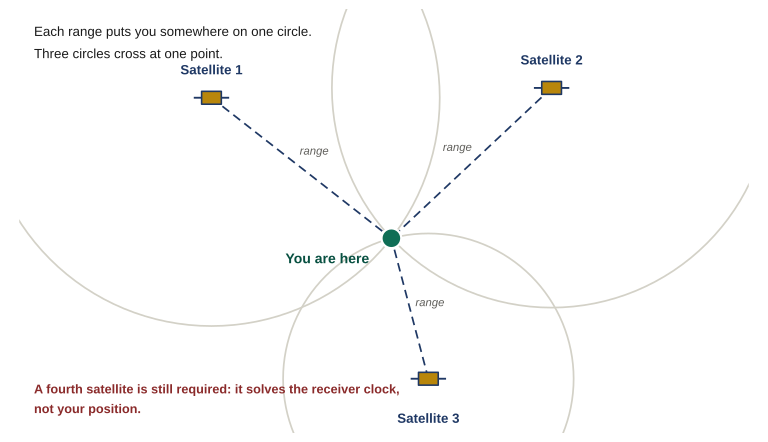
Three satellites with a range circle around each; all three circles cross at one marked ground position.

Figure 1.1 Three ranges narrow you to one point, which is why trilateration is usually described as needing three satellites. It needs four. The arithmetic assumes the receiver knows the exact time, and it does not — so the receiver’s own clock error is solved as a fourth unknown alongside latitude, longitude and altitude.

Which raises an obvious question: if three ranges are enough, why will no receiver report a position until it has four satellites?

Because the arithmetic above assumes your receiver knows the exact time, and it does not. Your device keeps time with an inexpensive quartz oscillator, not an atomic clock. A timing error of one millionth of a second — a microsecond, a rounding error by any ordinary standard — produces a range error of roughly 300 meters. Putting an atomic clock in a handheld is not an option, so receivers do something cleverer: they treat their own clock offset as a fourth unknown and solve for it at the same time as latitude, longitude, and altitude. Four unknowns need four equations, and each satellite supplies one.

The consequence matters more than the mechanism. Your position is the solution to a system of equations, not something the device looked at and saw. Feed that system slightly wrong inputs and it does not stop, throw an error, or go blank. It produces a slightly wrong answer, displayed with exactly the same confidence as a correct one. Everything else in this lesson follows from that.

Knowledge Check

A receiver needs signals from at least four satellites before it will report a position. What is that fourth signal doing?


2. The accuracy figure is the device’s estimate of its own work

Somewhere on your device is a number reading something like Accuracy: 4 m. Learn to read it correctly, because nearly everyone reads it as a guarantee and it is not one. Manufacturers label it differently — estimated position error, position accuracy, position error, or simply accuracy — and in every version the operative word is estimated.

The receiver computes that figure from two things it can genuinely measure: the geometry of the satellites it is currently tracking, and the strength and quality of the signals arriving from them. Good spread across the sky and strong, clean signals produce a small number. Clustered satellites and weak signals produce a larger one. Within its own terms, the estimate is honest work.

The problem is the class of error it cannot see. Suppose a signal reaches you not directly but after bouncing off a wet rock face fifty meters away. It arrives strong. It arrives clean. Its timestamp is valid and uncorrupted. It simply arrives late, because it traveled farther — and the receiver has no means whatsoever of knowing it took the long way around. That inflated range goes into the solution as though it were direct, your plotted position shifts, and the accuracy figure does not move, because from the receiver’s point of view nothing about that signal looked wrong.

Read the accuracy figure as a floor on plausible error, never as a ceiling on actual error. A small number means conditions look good for the errors the device is able to detect. It says nothing about the ones it cannot.

Knowledge Check

Your device reports an accuracy of 3 meters while you are working under heavy, wet canopy. What does that figure actually tell you?


3. Four conditions that degrade a fix

Four conditions account for most of the bad fixes a member will meet in the field. Learn the situation that produces each one, because in almost every case you can predict a degraded fix from the ground you are standing on before the device tells you anything at all.

Satellite geometry

Accuracy depends less on how many satellites you are tracking than on how they are spread across the sky. Satellites low and clustered in one quarter of the sky intersect at shallow angles, and shallow angles smear the solution into a long, thin error ellipse. Satellites spread evenly, some high and some low, cut it down tightly. Receivers express this as DOP, dilution of precision, often split into horizontal and vertical components. You do not control it directly, but terrain does: a narrow valley, a steep face, or a street between tall buildings leaves you a strip of visible sky and therefore a clustered set of satellites.
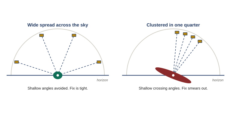
Two sky diagrams side by side: satellites spread evenly above a horizon with a small round error area, and satellites bunched into one quarter with a long thin error ellipse.

Figure 1.2 Accuracy depends on how the satellites are spread, not on how many there are. Wide spacing gives steep crossing angles and a tight fix. Satellites clustered in one quarter of the sky cross at shallow angles and smear the solution into a long, thin ellipse. Terrain decides which of these you get.

Multipath

A signal that reflects off rock, water, wet ground, a building face, or a vehicle before reaching you has traveled farther than the direct path, and the receiver reads that extra travel as extra distance. Urban ground is the worst case, which is why NAV-04 carries this problem further. Heavy wet canopy is the second. Multipath produces the specific, memorable symptom of a position that wanders or jumps by tens of meters while you stand perfectly still.
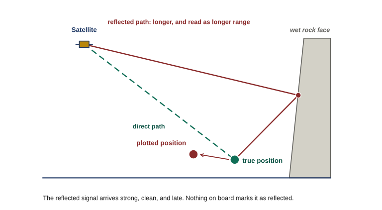
A satellite signal reaching a receiver by two routes, a direct path and a longer path reflected off a rock face, with the plotted position offset from the true position.

Figure 1.3 A signal that reflects off rock before reaching you has traveled farther, and the receiver reads that extra travel as extra range — which shifts the plotted position away from where you are standing. The reflected signal arrives strong, clean and late, and nothing on board marks it as reflected.

Cold starts and stale orbital data

To use a satellite, a receiver needs current data describing where that satellite actually is, and it collects that data from the satellites themselves, slowly. A device that has sat in storage for months, has traveled several hundred miles since it was last switched on, or has had its batteries out will need to gather it again. Expect a long first fix — minutes rather than seconds — and treat the first positions offered with suspicion. The fix worth having is the one taken after the device settles.

Knowledge Check

You take a handheld out of storage after several months, fit fresh batteries, and switch it on in the open. It takes four minutes to report a position. What is going on?


Vertical error

Elevation is the weakest number your device produces. Every satellite you are tracking sits above you and none sit below you, so the geometry that constrains your horizontal position well constrains your height poorly. As a working rule, vertical error runs somewhere between one and a half and three times the horizontal error on the same fix. A device claiming five meters horizontally may be off by fifteen vertically — enough to place you on the wrong bench, the wrong terrace, or the wrong side of a saddle.
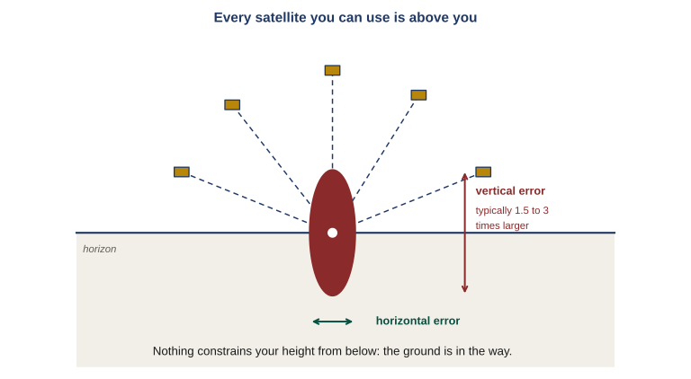
Side view of a receiver on a horizon line with every satellite above it and a tall narrow error ellipse; horizontal and vertical error spans are marked.

Figure 1.4 Every satellite you can use sits above the horizon and none sit below it, so nothing constrains your height from underneath. Vertical error typically runs one and a half to three times the horizontal error on the same fix — a device claiming five meters horizontally may be fifteen meters out on elevation.

Condition Where to expect it What the device tends to show
Satellite geometry Narrow valleys, steep faces, streets between tall buildings, dense canopy Position stays put; accuracy figure climbs and stays high; improves gradually
Multipath Urban ground, wet rock, standing water, metal structures, vehicles Position jumps while you are stationary; accuracy figure may look normal throughout
Cold start First use after storage, battery change, or long-distance travel Very slow first fix; early positions unstable, then settle
Vertical error Every fix, always, everywhere Elevation readout looks as confident as the grid does, and is not

Two of these fail in visibly different ways, and telling them apart in the field is worth more than either definition. Poor geometry degrades a fix steadily: the position holds still, the accuracy figure climbs and stays elevated, and things improve gradually as satellites move or you reach more open sky. Multipath degrades a fix erratically: the position jumps while you are stationary, the accuracy figure may look fine the whole time, and the behavior changes second to second as the reflection geometry changes. Steady and pessimistic is geometry. Jumpy and confident is multipath.

Knowledge Check

You stop in a steep, narrow drainage with wet rock walls. Standing still, you watch your plotted position jump back and forth between two points roughly forty meters apart. Which condition best explains what you are seeing?


4. Where the device belongs: GPS in a PACE plan

PACE stands for primary, alternate, contingency, emergency. It is a planning habit borrowed from communications, and it transfers to navigation cleanly: you decide in advance, standing somewhere comfortable where thinking is easy, what you will do when your first choice stops working.

For most members the legs run something like this:

PPrimary — handheld or phone GPS, configured to the group standard.
↓
AAlternate — a second, independent device. Different hardware, its own power, offline maps already loaded.
↓
CContingency — paper map and compass, with the device still available as a cross-check.
↓
EEmergency — paper map and compass alone, no electronic assistance of any kind.

Two things about that list are easy to misread.

The first is that an alternate leg built from the same equipment is not an alternate leg. A phone and a handheld both drawing on the same power bank fail together the moment the power bank does, and a second device with no maps loaded is a paperweight the moment you lose signal. Independence is the entire point of the leg.

The second is the more important one, and it is the argument this course is built around.

The trigger most people get wrong

Stepping down a leg is not triggered by the device failing. It is triggered by the device and the ground disagreeing. A dead device announces itself and needs no plan; the case that gets people hurt is the device that is still on, still bright, still claiming four meters, and wrong — because it is being fed reflected signals off a canyon wall, or because someone changed a setting three weeks ago and nobody checked. That failure is silent by construction. The only thing that surfaces it is a member who compares the fix against the ground and notices they do not agree.

Which is why the framing for this course is deliberately blunt: GPS is the primary, and map and compass is the emergency. The device is faster and more precise than a paper map, right up until it is neither — and a member who cannot check a fix against terrain has no way of knowing which of those two situations they are currently in. That check is the subject of Lesson 6, and it is the skill this entire course exists to build.

Knowledge Check

In the PACE plan this lesson describes, what should trigger a move off the primary leg?


5. What the rest of this course does

Lesson 2 covers what is actually overhead: four independent satellite systems, and the two separate receiver capabilities that people routinely confuse with each other. Lesson 3 covers device selection and the settings that decide whether a coordinate is usable at all — map datum, coordinate format, north reference. It is the highest-value lesson in the course, because a datum or format mismatch is the most common way a perfectly correct coordinate puts a member hundreds of meters off the mark. Lesson 4 covers core operations and Lesson 5 covers planned routes, recorded tracks, and retracing your own path back out. Lesson 6 is the core of the course: transferring coordinates between device and paper map, and the decision rule for what to do when the two disagree. Lessons 7 through 9 cover reporting a position, device OPSEC, and operating when the signal is degraded or gone. Lesson 10 sets the group standard and puts all of it on the ground.

None of it changes the conclusion you should already be carrying out of this lesson: the device produces a claim, and a claim is something you check.

What to carry out of this lesson

  • A fix is a calculation from timing signals, not an observation. Feed it slightly wrong inputs and it produces a slightly wrong answer with the same confidence as a right one.
  • The accuracy figure is the receiver’s estimate of its own work. Treat it as a floor on plausible error, never a ceiling on actual error.
  • Geometry degrades a fix steadily; multipath degrades it erratically. Steady and pessimistic is geometry, jumpy and confident is multipath.
  • The trigger for stepping down a PACE leg is not the device failing. It is the device and the ground disagreeing.
Field Drill

Name the ground you actually operate on — the area around your home, your commute, the property you would move to, the nearest public land you use. Then, on paper:

  1. Identify which of the four conditions from Section 3 is most likely to degrade a fix there, and name what specifically about that ground causes it.
  2. Write down what you would expect to see on the device when it happens: position steady or jumping, accuracy figure elevated or normal.
  3. Write out your four PACE legs for that ground, naming equipment you actually own. If your alternate leg shares batteries with your primary, or has no offline maps on it, fix that before you start Lesson 3.

Keep this sheet. Lesson 10 returns to it when you build the group standard.

Answer all five knowledge checks to unlock Lesson 02
← NAV-06 Course Map

Login with Patreon

Login with Patreon

Search Site

Products

  • Family Emergency Plan and Household Recovery Workbooks - Patreon Family Emergency Plan and Household Recovery Workbooks - Patreon $34.95
  • Bundle - Family Emergency Plan and Household Recovery Workbooks Bundle - Family Emergency Plan and Household Recovery Workbooks $46.95
  • Household Recovery Workbook Household Recovery Workbook $29.95
  • The Continuity Chronicles Seal Decal The Continuity Chronicles Seal Decal $5.00 Original price was: $5.00.$3.00Current price is: $3.00.
  • Family Emergency Plan Workbook - Patreon Family Emergency Plan Workbook - Patreon $19.95
  • Personal Preparedness Assessment Workbook - Patreon Personal Preparedness Assessment Workbook - Patreon $19.95
  • The Next of Kin Workbook - Patreon The Next of Kin Workbook - Patreon $23.95
  • Personal Preparedness Assessment Report Personal Preparedness Assessment Report $179.95
  • Bundle - Family Emergency Plan + Next of Kin Workbooks Bundle - Family Emergency Plan + Next of Kin Workbooks $49.95
  • The Next of Kin Workbook The Next of Kin Workbook $29.95
  • ASAR — 50 Mile Radius ASAR — 50 Mile Radius $139.95
  • ASAR 50-MILE + FEP WORKBOOK ASAR 50-MILE + FEP WORKBOOK $169.95
  • ASAR — 50 Mile Radius - Patreon ASAR — 50 Mile Radius - Patreon $39.95
  • Bundle - The Series Starter (Paperback) Bundle - The Series Starter (Paperback) $29.98
  • The Brush (Paperback) The Brush (Paperback) $15.99
  • The Meadow Protocol (Paperback) The Meadow Protocol (Paperback) $13.99
  • Cards (4x6) - Brevity Cards for OTP Cards (4x6) - Brevity Cards for OTP $24.95
  • Communications Card bundle (13 cards) Communications Card bundle (13 cards) $41.95
  • Personal Preparedness Assessment Workbook Personal Preparedness Assessment Workbook $24.95
  • Family Emergency Plan Workbook Family Emergency Plan Workbook $24.95

Product categories

Cart

©2026 Fortune Favors the Prepared | Built using WordPress and Responsive Blogily theme by Superb