Skip to content

Fortune Favors the Prepared

Semper Paratus, Semper Gumby

Menu
  • The Continuity Chronicles
  • Intelligence Reports
        • DAILY THREAT REPORT
        • DAILY THREAT REPORT – LITE
        • DAILY PREPAREDNESS BRIEF
        • Analytical Standards and Tradecraft
        • Acronym & Abbreviations Glossary
        • Source Registry
        • FLASH & SPECIAL REPORTS
        • Area-Specific Assessment Report
        • SOFT TARGET SECURITY BRIEF
        • THE HOUSEHOLD BRIEF
        • COMMS WATCH
        • FINANCE SECTOR
        • HEALTHCARE SECTOR
        • TRANSPORTATION & LOGISTICS SECTOR
        • AI, DATA CENTER & INFRASTRUCTURE REPORT
        • CONSTRUCTION & MANUFACTURING SECTOR
        • Water and Wastewater Security Report
        • Energy Sector Report
        • Strategic Intelligence Supplement
  • WATCH DESK
  • About
        • The Why
        • Vision and Mission
        • Services
          • Business Resiliency
        • Testimonials
        • Insider
        • Friends
          • Patriot Volunteer Examiner (VE) Team
          • Angery American
          • Signal Stuff
          • Forward Observer
  • Communications
        • Stump Knocker
          • SOI
          • STUMP KNOCKER DMR UPDATES
          • MMDVM Hotspot
        • Preparedness Communications
          • What Radio Should I Get for Preparedness?
            • What Radio to Buy?
              • What Radio to Buy? – video
              • Ham Radio on a Budget
              • Live – What Radio to Buy?
              • Portable Radio Kit
              • Mobile Communications
          • Emergency Communications Principles
          • Communications Options
          • Starter Radio Paths by Preparedness Scenario
          • How Communications Fail
          • HF Communications
            • SHTF HF Communications
            • Simple Antenna Builds for HF – video
            • NVIS in Amateur Radio
        • Amateur (HAM) Radio
          • Why Do I Need a Ham License?
            • How to Obtain Your Amateur Radio License
              • Amateur Radio Learning Resources
              • Finding a Ham Exam
                • HAM Exam Accommodation
              • Getting Into Ham Radio – Video
            • Are You Expired?
            • Why You Should Upgrade to a General Ham License
          • HAM Simplex Frequency Card
          • Analog versus Digital
          • Analog vs Digital Voice: A Preparedness-Focused Comparison
          • What are CTCSS and DCS
          • Programming Radios with Software
          • ARES, RACES, ACS and AUXCOMM
          • Ham Radio Beyond Line-of-Sight
            • Linked Analog Repeaters
            • EchoLink and IRLP
            • AllStarLink
            • Yaesu System Fusion & WIRES-X
            • D-STAR
            • Digital Mobile Radio (DMR)
            • P25 in Amateur Radio
            • NXDN in Amateur Radio
            • Amateur Radio Satellites (AMSAT)
            • The 60-Meter Band (5 MHz)
          • Meshtastic
          • HAM VoIP
        • Personal Radio Services
          • FCC Rules for Personal Radio Services
          • Family Radio Service (FRS)
          • General Mobile Radio Service (GMRS)
            • GMRS Repeaters
            • Getting a GMRS License
            • FRS / GMRS / MURS Frequency Card
          • Multi-Use Radio Service (MURS)
          • Citizen Band (CB) Radio
            • CB Frequency Card
        • Other Radio Services
          • Communications Continuity Programs and Capabilities
          • Marine Communications
        • Cell Sites and Their Services
          • When Cell Service Fails
          • Radio over LTE and Rapid Radios
            • LTE Radio Comparison
        • Satellite Communications
          • America’s Secret Eyes
          • The Commercial Eye
          • Seeing Through Everything (SAR)
            • Remote Area Emergency Communication Devices
            • Which Beacon Should You Carry?
          • Personal Satellite Communications
        • Wired Communications
          • MAG Phone System
          • TA-312/PT Field Telephone and SB-22/PT Switchboard
          • Understanding Telephone Wiring
          • The AT&T Long Lines Program
        • Communications Planning
          • Communications Plan Annex
            • Communications P.A.C.E.
            • Finding Information for Your Communications Plan
            • Area-Specific Assessment Report
          • Automatic Link Establishment (ALE)
          • Understanding Communications Resiliency
        • Communications Resiliency Programs
          • ARES, RACES and ACS
          • Auxiliary Communications (AUXCOMM)
          • Military Auxiliary Radio System (MARS)
          • U.S. Coast Guard Auxiliary Communications
          • Civil Air Patrol Communications
          • The 60-Meter Band (5 MHz)
            • Understanding the 60-Meter Band
        • Government Communications Continuity Programs
          • Government Emergency Telecommunications Service (GETS) and Wireless Priority Service (WPS)
          • National Warning System (NAWAS)
          • National Interoperable Frequencies
          • The FEMA National Net (FNARS)
          • National Emergency Communications Network (NECN)
          • The SHARES Program
          • State Emergency Capability Using Radio Effectively (Operation SECURE)
          • The High Frequency Global Communications System (HFGCS)
          • Satellite Mutual Aid Radio Talkgroup (SMART)
          • The AT&T Long Lines Program
        • Communications & Emissions Discipline
          • Communications Security (COMSEC)
            • Book Cipher
            • One Time Pads (OTP)
              • Decrypting One Time Pad Message
              • One Time Pads (OTP) Live Video
              • One Time Pad Training
          • Cryptographic Security (CRYPTOSEC)
          • Transmission Security (TRANSEC)
          • Communications Transmission Discipline (TRANSDISC)
          • Emissions Control (EMCON)
          • Communications & Emissions Training Framework
        • DMR Programming
          • DMR Programming – Talk Groups
          • DMR Programming - Roaming
          • MMDVM and Yaesu System Fusion (YSF)
          • Encryption in DMR Radios
        • Digital Mobile Radio (DMR) Networks
          • WR3IRS Interstate DMR Network
            • South Central PA (SC PA)
            • North East PA (NE PA)
            • Washington-Baltimore (W-B)
            • West Central Florida (WCF)
          • Florida Digital Amateur Radio Network (F-DARN)
          • Southeast Florida DMR Repeater Network W2GGI
          • Virginia DMR (DMRVA)
          • NC PRN DMR Network
          • SC Hospital Emergency Amateur Radio Team (SCHEART)
          • HEARS – Hospital Emergency Amateur Radio System
          • New England Digital Emergency Communications Network (NEDECN)
        • Baofeng/BTECH Radios Quick Guide
          • Manually Programming a Baofeng Radio – Video
          • A User’s User Manual for Baofeng Radios
        • MESSAGES & REPORTS
          • Phonetics
          • Procedure Words (Prowords)
          • Date Time Group (DTG)
          • NTS Radiogram Form
            • ARL Numbered Radiograms
          • SALUTE, SPOT, and SALT Reports
          • ACE/LACE Reports
          • GOTWA Report
          • CASREP (Casualty Report) Format
          • MEDEVAC Request Report
          • Formatted Messages (downloads)
        • Communications Knowledge Library
          • Communications Resiliency
          • Radio Etiquette, Jargon, and Best Practices
          • AmRRON RESOURCES & REFERENCES
          • Anytone Programmable Keys
          • Phonetics
          • Amateur Radio Colorado
            • Colorado Linked Repeater Systems
        • COMMUNICATIONS REFERENCES
  • Planning
        • Family Emergency Plan – The Basics
          • Family Emergency Plan
            • Area-Specific Assessment Report
          • Why Every Family Needs an Emergency Plan
        • Family Contingency Binder
          • Family Contingency Binder MindMap
        • Triggers
          • Preparedness Conditions – PREP-CON
            • Preparedness Conditions (PREP-CON) MindMap
          • Space Weather
        • Family Emergency Plan Workbook
          • Family Emergency Plan Workbook - owner resources
            • Area-Specific Assessment Report
            • Family Emergency Planning Form
            • Communications Plan
              • P.A.C.E.
            • Emergency Evacuation
            • Emergency Food Supplies
            • Family Contingency Binder
            • Message Drops
            • Get Home Bag
            • Bug Out Bag & Bins
            • Miscellaneous
        • Household Recovery Workbook
          • Household Recovery Workbook Updates
          • Disaster Debris — What to Do at the Curb
          • Dealing With Grief
        • Next of Kin Workbook
          • Next of Kin Workbook Updates
        • METT-TC: Decision Discipline
          • METT-TC - tactical planning
        • Planning Your Preps
          • Charity in Planning
        • Mutual Assistance Group
          • Mutual Assistance Group Workbook
            • MAG Workbook Forms & Updates
          • Mutual Assistance Groups (MAGs): Skills, Vetting, and Building Real Resilience
          • Mutual Assistance Group (MAG): Recruitment Code of Conduct
          • MAG: Private Vetting & Intake Process
          • Compartmentalization in Mutual Assistance Groups (MAGs)
          • Resiliency Index
          • Continuity of Government & Application to MAGs
  • Threat Assessment
        • Personal Preparedness Assessment Workbook
          • Personal Preparedness Assessment Report
          • Personal Preparedness Assessment Workbook - owner resources
        • Readiness Conditions for Preparedness
          • PREP-CON - Preparedness Conditions
          • COMCON – Communications Readiness Condition
          • WX-CON Weather Conditions
          • SWX-CON Space Weather Condition
          • CONCON – Civilian Continuity Conditions
        • Readiness Conditions – Hierarchy and Relationships
          • LERTCON – Alert Condition
          • DEFCON – Defense Readiness Condition
          • COGCON - Continuity of Government
          • INFOCON – Information Operations Condition
          • FPCON – Force Protection Condition
          • EMERCON – Emergency Condition
          • CYBERCON – Cyber Readiness Conditions
          • CPCON – Cyberspace Protection Condition
          • WATCHCON – Watch Condition
          • SIPRNet – Secret Internet Protocol Router Network
          • REDCON – Readiness Condition
          • NC3CON – Nuclear Command, Control, and Communications
        • Readiness Conditions in The Conspiracy Chronicles
          • CERCON – Cerberus Readiness Condition
          • COMCON – Communications Readiness Condition
          • C-OPS – CERBERUS Operational Status Conditions
          • CONCON – Civilian Continuity Conditions
        • Being Prepared for Civil Unrest
          • Civil Unrest – Area Intelligence
          • Civil Unrest – Be Prepared
          • Civil Unrest – Defense
          • Civil Unrest – Defense (part 2)
        • Staying Informed Before, During and After Emergencies
          • Weather Awareness
            • Weather Event Codes
            • Weather Radio Comparison
        • Cascade Analysis & Infrastructure
          • Cascade Effects
          • Community Lifelines
          • Area Intelligence
          • Area-Specific Assessment Report
          • National Power Grid
        • Near Earth Object / End of Life Event (ELE)
  • Intelligence
        • ANALYSIS, TRADECRAFT & REPORTING
          • Analytical Standards and Tradecraft
          • Analytical Tradecraft: A Guide to OSINT Analysis
            • OSINT Analysis Study & Reference Guide
          • Understanding Intelligence Analysis Tools
            • Understanding Analysis of Competing Hypotheses (ACH)
            • Understanding MDCOA
            • Understanding OAKOC
        • Operations Security (OPSEC)
          • OPSEC for Teens
          • OPSEC for Kids
          • The Gray Man
          • OPSEC: Don't Become the Target
          • Counterintelligence Tradecraft for the Prepared
        • Community Intelligence
          • Area Intelligence – Now!
            • Area-Specific Assessment Report
          • Community SITREP
          • Radio Traffic Situational Analysis During Emergencies
          • SALUTE, SPOT, and SALT Reports
        • ELECTRONIC THREAT & SURVEILLANCE
          • Staying Informed Before, During and After Emergencies
          • Integrated Public Alert and Warning System (IPAWS)
          • Communications Continuity Programs and Capabilities
          • Short Wave Scanning
          • Seeing Through Everything (SAR)
            • Which Beacon Should You Carry?
          • Wireless Recon Devices
          • Flock Cameras – What You Need to Know
        • The Architecture of Intelligence
        • Intelligence Gathering & Analysis
        • INTELLIGENCE DISCIPLINES
          • Communications Intelligence (COMINT)
          • Electronic Intelligence (ELINT)
          • Tactical Electronic Intelligence (TACELINT)
          • Signals Intelligence (SIGINT) – the basics (2020)
          • Signals Intelligence – Information Gathering Basics (2022)
          • Signals Intelligence (SIGINT)
          • Technical & Infrastructure Intelligence (TECHINT)
          • Electronic Counter-Surveillance
          • Open-Source Intelligence (OSINT)
            • How to Conduct a Daily Threat Analysis Using OSINT
          • Measurement and Signature Intelligence (MASINT)
          • Electronic Surveillance (ES)
          • Overhead Imagery & Geospatial Intelligence (IMINT / GEOINT)
        • INTELLIGENCE REFERENCES
  • Medical
        • Medical Training
          • Patient Assessment & Casualty Management
            • MARCH-PAWS Rapid Assessment
              • MARCH-PAWS TRAINING CURRICULUM
            • DCAP-BTLS – Secondary Trauma Assessment
            • SAMPLE + OPQRST Secondary Assessment
              • Medical History as a Preparedness Skill
            • START Triage
            • MEDEVAC Request Report
            • Patient Assessment – Documentation
              • Patient Care Report Forms
              • CASREP (Casualty Report) Format
        • Medical Kits
          • Individual First Aid Kit (IFAK)
          • BooBoo and IFAK Kits Video
          • BooBoo & IFAK Kit Mind Map
          • Large Kit - video
        • Medical Myths
          • Medical Myths – Tampons
          • Medical Myths – Ingested Poisoning
        • MEDICAL REFERENCES
  • Transportation
    • Transportation Plan B
    • Improvised Transportation
    • Preparedness For Winter Travel
  • Animals
    • Preparedness for Pets
  • Food
        • Why You Should Start a Food Storage Plan
        • Food Storage Quick Start
        • Buying in Bulk
        • Inventory Tracking
        • FOOD PRESERVATION RESOURCES
  • Water
    • Water From Air
  • Power
        • Power Grid
        • UPS
        • The Data Center Next Door
  • Bags etc.
        • Bug Out versus Get Home Bags
        • Get Home Bag – Contents
          • Get Home Bag – video
          • Get Home and Bug Out Bags - video from live 2-10
  • Navigation & Signalling
        • Grid Coordinates and Map Reading
        • Map & Compass Land Navigation
        • Practitioners Guide to GPS
          • Quick Instruction Sets
        • Which Emergency Beacon Should You Carry?
        • Covert Signals
        • Emergency Signaling
        • Sketched Strip Map
  • References
        • PLANNING & OPERATIONS
        • SECURITY OPERATIONS
        • INTELLIGENCE
        • CRYPTOLOGY
        • COMMUNICATIONS
        • REPORTING FORMATS
        • GENERAL/MISC
        • MEDICAL
        • FOOD PRESERVATION
        • CRITICAL INFRASTRUCTURE
        • SURVIVAL MANUALS
        • OPSEC
        • COUNTER INSURGENCY & CIVIL DISTURBANCE
        • EMP / CME
        • Training
          • Training Videos
          • One Time Pad (OTP) Exercises
            • 45662
            • 222135ZDEC22
        • Media and Press
  • Blog
    • Boomer
      • Day 1 – The Journey Home
      • Day 2 – First Day in the New Home
      • Day 3 – More Training
      • Day 4 – Dad Goes Back to Work
      • Day 5 – A Day at Home with More Training with Dad (Boomer’s version)
      • Day 6 – More Training with Dad at Home
      • Day 7 – Dad Goes Back to Work, Boring Day
    • Mountain Readiness Fallout Workshops
    • Mapping DMR Repeaters
    • COMMUNICATIONS RESILIENCY
    • Getting The Message Through
    • What are you preparing for?
    • Never Let an Opportunity Go To Waste
    • Cascade Effects and the Perfect Storm
    • DO NOT REPLY
    • Space Weather Warning
    • Good, and Sad, News
    • Necessity vs. Luxury
    • Don’t Put off Until Tomorrow
    • No Plan Survives First Contact
    • Threat and Hazard Identification and Risk Assessment (THIRA)
    • Live – What Radio to Buy?
    • Big Daddy Unlimited Affiliate
    • Food – Tue 16th 7pm MST
    • Live from 2021-2-3
    • Live 2021-01-26
    • FLASH SALE
    • Live 2021-01-11
    • What Is Freedom?
    • Preparedness for Pets
    • What If The Lights Go Out?
    • Hoarding or Prepping?
    • Why Do I Need a Ham License?
    • How Bad is the SolarWinds Orion Issue?
    • How To Begin Prepping
    • Members Only Live Videos
    • Live 11/24
    • Ham Radio VoIP Phone
    • Training Calendar
    • A Chat (with some whisky)
    • Blog 2020 11 02
    • Live with Charlie Hogwood
    • EARTH EX 2020
    • A Live with Angery American
    • Have You Woken Up Yet?
    • BUG OUT READY
    • The Gray Man
    • Area Intelligence – Now!
    • Being Prepared for Civil Unrest
    • It Depends
    • The Art of Being Prepared – The New Prepper
    • Get Home versus Bug Out Bags
    • Why You Need an IFAK AND Training
  • Training Curriculum
  • Shop
  • Contact
    • Mailing List
Menu

NAV-06 Navigation Using a GPS Lesson 5

NAV-06 · Lesson 05

Routes, Tracks, and Retracing Your Path

Deciding at the map table instead of on the ground, and knowing which of the two lines on your screen is a plan and which is history.

Reading: about 15 minutes  ·  Field drill: about 1 to 2 hours

Bottom Line Up Front

A route is a plan: an ordered list of named points with legs between them, built before you move. A track is a recording: a string of positions the device sampled while you walked. They look similar on screen and they are not the same object, cannot be used the same way, and fail in different directions.

The work that makes a route worth having happens at the map table, not in the menus. This lesson covers building one from map recon, doing that on a computer where the screen is big enough to think on, naming points so the whole group can read them, setting a recording interval that keeps what matters, and the specific limits of retracing your own path back out.

Recall Check · L04

From Lesson 04, before we plan anything: you enter a position somebody read to you, then check it. Which check can actually catch your error?


1. Two lines that mean different things

Both draw as a line over your map. Everything else about them differs.

Route Track
What it is An ordered list of stored points, with legs between them A string of recorded positions with timestamps
When it exists Before you move Only after you have moved
Made of Points you chose deliberately, usually a handful Points the device sampled automatically, often thousands
Carries Your decisions: where to turn, where to check, what to avoid What happened, including detours and mistakes
Reusable Yes, forwards or reversed, by anyone you send it to Only as a breadcrumb of one particular trip

The distinction has a practical edge. A route can be handed to another member and walked without them knowing anything about the ground, because the thinking is baked into the points. A track hands them your afternoon, wrong turns included.
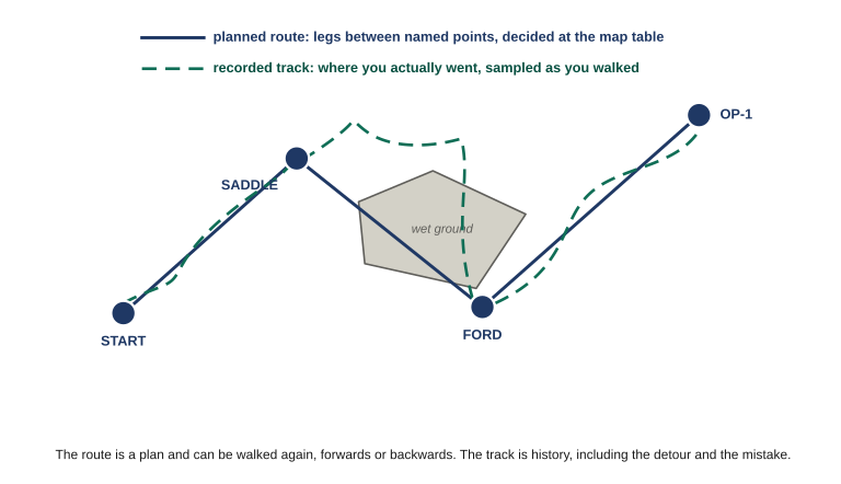
Four named waypoints joined by straight route legs, with a wandering recorded track detouring around an area of wet ground the planned route runs straight through.

Figure 5.1 Notice where the planned legs run straight through the wet ground: the plan was made from a map that did not show it. The recording is the only one of the two that knows the detour happened.

Knowledge Check

You want to send another member the way in to a site you have used before. Why is your recorded track from last time a poor thing to send?


2. Building a route from map recon

Route building is map work that happens to end in a device. The device is where you store the answer, not where you work it out.

Start on the map with the whole leg in front of you and decide where the turning points are. A good turning point has two properties: it is somewhere a decision actually gets made, and it is identifiable on the ground when you get there. A saddle, a stream junction, a road crossing, a spur nose, a fence corner. A point in the middle of a uniform slope satisfies neither — nothing changes there and you cannot confirm you have arrived.

Then keep the legs honest. A leg that runs four kilometers through broken country is not one leg, it is a place for four kilometers of error to accumulate before anything tells you. Break it where the ground gives you something to check against. The legs do not need to be equal; they need to end somewhere you can stand and say, without the device, that you are where you meant to be.

Every point you put in a route is a decision you have made in advance and will not have to make while tired, wet, or under time pressure. That is the entire value of doing this beforehand, and it is why a route with three well-chosen points beats one with twenty arbitrary ones.

Two things to plan in that are easy to forget. Put a point at anywhere you would want to stop and confirm position deliberately — those become the checkpoints Lesson 06 uses. And plan the route so it is still sensible reversed, because the way out is the way in backwards more often than not.

Knowledge Check

Which of these makes the best turning point in a planned route?


3. Planning on a computer

You can build a route on the device itself, point by point, on a screen the size of a playing card. It works and it is miserable, and it is why almost nobody does proper map recon that way.

The better approach is to plan on a computer, where you can see the whole area at once, zoom without losing your place, and change your mind cheaply. Garmin publishes BaseCamp free for this: you build waypoints, routes and tracks on the desktop against whatever maps you have loaded, then transfer them to the device over USB. Their device-side documentation treats it as the standard path, alongside the newer Garmin Explore service which syncs the same objects between phone, web and handheld and can push offline maps out to a phone. Other platforms have their own equivalents, and the workflow is the same whichever you use.

Step 1Map reconDecide the turning points on the map, on paper or on screen. This is the part that matters.
→
Step 2BuildEnter the points on the computer, in order, naming each one to the group standard as you go.
→
Step 3TransferSend it to the device, then open it on the device and confirm the points arrived intact.
→
Step 4Print the backupMark the route on the paper map and write the grids down. The plan must survive the device.
→
Step 5Review afterPull the recorded track back onto the computer and compare it against what you planned.

Three cautions come with planning software, and all three have bitten people.

It will route you, and it does not know what you know. Ask most of these tools for a route between two points and they will happily generate one along roads and trails, optimized for distance or time. That is a suggestion from a database, not a plan. It has no idea the bridge is out, the landowner is hostile, or that the obvious trail is the one everybody watches. Use auto-routing to draw quickly, then go back and impose your own turning points on it.

Settings do not travel with the file the way you assume. Datum and coordinate format are display settings at both ends. Check on the device, after the transfer, that the points read where you expect — the same read-back discipline from Lesson 04, applied to a file instead of a keypad.

A cloud-synced plan is a plan stored on somebody else’s computer. The convenience of having routes appear across phone, web and handheld means the route also exists on a server, tied to your account, with timestamps. That is a real capability and a real exposure, and Lesson 08 deals with it properly. For now: know which of your tools sync and which stay local.

Knowledge Check

Planning software offers to generate a route between your start point and your objective automatically. What is the right use of that?


4. Names the whole group can read

A route is only transferable if its points mean something to the person receiving it. The device will name them 001, 002, 003, and a route made of those is a route only its author can use.

A workable convention has three parts and stays short enough to read on a small screen:

PurposeRPWhat kind of point it is: rally point, objective, cache, water, checkpoint, hazard
LocatorMILLA short, memorable tie to the ground — a feature name, not a coordinate
Sequence02Where it sits in the route, so an alphabetical list sorts into walking order

Put together: RP-MILL-02. Somebody who has never seen your route knows what that point is for, roughly where it is, and where it comes in the sequence, from six characters on a dark screen.

Two rules matter more than the exact scheme. Pick one convention for the whole group and write it into the standard — two members using different schemes produces a shared route nobody can read at speed. And never encode anything in a name you would not want read aloud on an open net, which is a point Lesson 08 returns to.

Knowledge Check

Why does a naming convention put the sequence number at the end rather than the beginning?


5. Recording a track

Track recording is usually on by default and quietly running whenever the device is. Three settings control it and they trade against each other.

Whether it records at all. There are good reasons to have it on: reviewing a route afterwards, proving where a team went, and retracing your way out. There are good reasons to have it off, and they are the subject of Lesson 08.

How it decides to drop a point. Devices typically offer automatic, by distance, or by time. Automatic varies the rate to represent the shape of the path efficiently and is the right default. By distance gives you evenly spaced points regardless of speed. By time gives you a point every so many seconds, which produces dense clusters wherever you stop.

How often. This is the real tradeoff, and it is between fidelity on one side and battery and memory on the other.
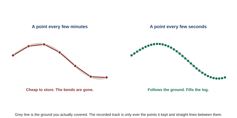
The same curved path recorded twice: sparsely, with straight chords cutting across the bends, and densely, following the curve closely.

Figure 5.2 A track is never the path you walked. It is the points the device kept, joined by straight lines. Record sparsely and the bends get cut — which matters if you intend to follow that line back through country where the bend was the reason for the turn.

The thing to understand is that a track is never the path you walked. It is the points the device kept, joined by straight lines. Record sparsely and every bend gets cut, the distance comes out short, and a tight turn can vanish entirely — which matters if you intend to follow that line back through terrain where the bend was the reason for the turn.

Knowledge Check

A member records a track at a long interval to save battery, then uses it to retrace their way out through close country. What is the specific risk?


6. Retracing your path is not following a route

Most devices offer a way to turn your recorded track around and lead you back along it. It is genuinely valuable and it is routinely over-trusted, so be precise about what it does.

It leads you back along where the device recorded you going — sampled at whatever interval was set, including every detour, and only as far back as the current recording extends. That makes it excellent for one specific situation: you are somewhere you got to safely, visibility or light has collapsed, and the highest priority is undoing your own movement exactly. In a whiteout or after dark on ground you crossed in daylight, that is a genuine lifeline.

Three ways it lets you down

It retraces your mistakes. If you went the wrong way for twenty minutes and corrected, the return path includes those twenty minutes. Nothing distinguishes the good line from the bad one.

It assumes the way in is still the way out. The creek you stepped over rises. The slope you came down in daylight is a different proposition climbing in the dark. The track records that you passed, not that you could pass again.

It only exists if recording was on. A device that was switched off, cleared, or in a battery-saving mode with logging disabled has nothing to give you. This is a capability you have to have set up before you needed it.

Which is why it is a fallback rather than a plan. A route you built at the map table can be walked forwards, reversed, handed to somebody else, and reconstructed from paper if the device dies. Retracing gives you exactly one thing: your own footsteps back, if the device kept them.

Knowledge Check

In which situation is retracing a recorded track the right tool rather than a reversed route?


What to carry out of this lesson

  • A route carries your decisions and can be handed to anyone. A track carries one afternoon, mistakes included.
  • A good turning point passes two tests: a decision gets made there, and you could confirm arrival without the device.
  • Planning software optimizes on map data and knows nothing you know. Let it draw; keep the judgment.
  • A track is only the points kept and the straight lines between them. Retracing is a fallback for undoing your own movement exactly, not a plan.
Field Drill

Half of this is at a table and half is on the ground.

  1. Take a real objective in your area and build a route to it on paper first, marking turning points that satisfy both tests: a decision happens there, and you could confirm arrival without the device. Aim for the fewest points that do the job.
  2. Build the same route on a computer if you have the software, name every point to a convention you write down, and transfer it. Open it on the device and confirm every point arrived where you meant.
  3. Walk it. Record the track. At each turning point, confirm you have arrived by looking at the ground before you look at the screen.
  4. Afterwards, pull the track back and lay it over the route. Where they diverge, work out whether the ground was wrong or the plan was.
  5. Check your recording interval and work out how long the device would log for at that setting. If you do not know, that is the finding.

Keep the route and the naming convention. Lesson 10 builds the group standard on top of them.

Answer all six knowledge checks to unlock Lesson 06
← Lesson 04: Core Operations

Login with Patreon

Login with Patreon

Search Site

Products

  • Family Emergency Plan and Household Recovery Workbooks - Patreon Family Emergency Plan and Household Recovery Workbooks - Patreon $34.95
  • Bundle - Family Emergency Plan and Household Recovery Workbooks Bundle - Family Emergency Plan and Household Recovery Workbooks $46.95
  • Household Recovery Workbook Household Recovery Workbook $29.95
  • The Continuity Chronicles Seal Decal The Continuity Chronicles Seal Decal $5.00 Original price was: $5.00.$3.00Current price is: $3.00.
  • Family Emergency Plan Workbook - Patreon Family Emergency Plan Workbook - Patreon $19.95
  • Personal Preparedness Assessment Workbook - Patreon Personal Preparedness Assessment Workbook - Patreon $19.95
  • The Next of Kin Workbook - Patreon The Next of Kin Workbook - Patreon $23.95
  • Personal Preparedness Assessment Report Personal Preparedness Assessment Report $179.95
  • Bundle - Family Emergency Plan + Next of Kin Workbooks Bundle - Family Emergency Plan + Next of Kin Workbooks $49.95
  • The Next of Kin Workbook The Next of Kin Workbook $29.95
  • ASAR — 50 Mile Radius ASAR — 50 Mile Radius $139.95
  • ASAR 50-MILE + FEP WORKBOOK ASAR 50-MILE + FEP WORKBOOK $169.95
  • ASAR — 50 Mile Radius - Patreon ASAR — 50 Mile Radius - Patreon $39.95
  • Bundle - The Series Starter (Paperback) Bundle - The Series Starter (Paperback) $29.98
  • The Brush (Paperback) The Brush (Paperback) $15.99
  • The Meadow Protocol (Paperback) The Meadow Protocol (Paperback) $13.99
  • Cards (4x6) - Brevity Cards for OTP Cards (4x6) - Brevity Cards for OTP $24.95
  • Communications Card bundle (13 cards) Communications Card bundle (13 cards) $41.95
  • Personal Preparedness Assessment Workbook Personal Preparedness Assessment Workbook $24.95
  • Family Emergency Plan Workbook Family Emergency Plan Workbook $24.95

Product categories

Cart

©2026 Fortune Favors the Prepared | Built using WordPress and Responsive Blogily theme by Superb