Skip to content

Fortune Favors the Prepared

Semper Paratus, Semper Gumby

Menu
  • The Continuity Chronicles
  • Intelligence Reports
        • DAILY THREAT REPORT
        • DAILY THREAT REPORT – LITE
        • DAILY PREPAREDNESS BRIEF
        • Analytical Standards and Tradecraft
        • Acronym & Abbreviations Glossary
        • Source Registry
        • FLASH & SPECIAL REPORTS
        • Area-Specific Assessment Report
        • SOFT TARGET SECURITY BRIEF
        • THE HOUSEHOLD BRIEF
        • COMMS WATCH
        • FINANCE SECTOR
        • HEALTHCARE SECTOR
        • TRANSPORTATION & LOGISTICS SECTOR
        • AI, DATA CENTER & INFRASTRUCTURE REPORT
        • CONSTRUCTION & MANUFACTURING SECTOR
        • Water and Wastewater Security Report
        • Energy Sector Report
        • Strategic Intelligence Supplement
  • WATCH DESK
  • About
        • The Why
        • Vision and Mission
        • Services
          • Business Resiliency
        • Testimonials
        • Insider
        • Friends
          • Patriot Volunteer Examiner (VE) Team
          • Angery American
          • Signal Stuff
          • Forward Observer
  • Communications
        • Stump Knocker
          • SOI
          • STUMP KNOCKER DMR UPDATES
          • MMDVM Hotspot
        • Preparedness Communications
          • What Radio Should I Get for Preparedness?
            • What Radio to Buy?
              • What Radio to Buy? – video
              • Ham Radio on a Budget
              • Live – What Radio to Buy?
              • Portable Radio Kit
              • Mobile Communications
          • Emergency Communications Principles
          • Communications Options
          • Starter Radio Paths by Preparedness Scenario
          • How Communications Fail
          • HF Communications
            • SHTF HF Communications
            • Simple Antenna Builds for HF – video
            • NVIS in Amateur Radio
        • Amateur (HAM) Radio
          • Why Do I Need a Ham License?
            • How to Obtain Your Amateur Radio License
              • Amateur Radio Learning Resources
              • Finding a Ham Exam
                • HAM Exam Accommodation
              • Getting Into Ham Radio – Video
            • Are You Expired?
            • Why You Should Upgrade to a General Ham License
          • HAM Simplex Frequency Card
          • Analog versus Digital
          • Analog vs Digital Voice: A Preparedness-Focused Comparison
          • What are CTCSS and DCS
          • Programming Radios with Software
          • ARES, RACES, ACS and AUXCOMM
          • Ham Radio Beyond Line-of-Sight
            • Linked Analog Repeaters
            • EchoLink and IRLP
            • AllStarLink
            • Yaesu System Fusion & WIRES-X
            • D-STAR
            • Digital Mobile Radio (DMR)
            • P25 in Amateur Radio
            • NXDN in Amateur Radio
            • Amateur Radio Satellites (AMSAT)
            • The 60-Meter Band (5 MHz)
          • Meshtastic
          • HAM VoIP
        • Personal Radio Services
          • FCC Rules for Personal Radio Services
          • Family Radio Service (FRS)
          • General Mobile Radio Service (GMRS)
            • GMRS Repeaters
            • Getting a GMRS License
            • FRS / GMRS / MURS Frequency Card
          • Multi-Use Radio Service (MURS)
          • Citizen Band (CB) Radio
            • CB Frequency Card
        • Other Radio Services
          • Communications Continuity Programs and Capabilities
          • Marine Communications
        • Cell Sites and Their Services
          • When Cell Service Fails
          • Radio over LTE and Rapid Radios
            • LTE Radio Comparison
        • Satellite Communications
          • America’s Secret Eyes
          • The Commercial Eye
          • Seeing Through Everything (SAR)
            • Remote Area Emergency Communication Devices
            • Which Beacon Should You Carry?
          • Personal Satellite Communications
        • Wired Communications
          • MAG Phone System
          • TA-312/PT Field Telephone and SB-22/PT Switchboard
          • Understanding Telephone Wiring
          • The AT&T Long Lines Program
        • Communications Planning
          • Communications Plan Annex
            • Communications P.A.C.E.
            • Finding Information for Your Communications Plan
            • Area-Specific Assessment Report
          • Automatic Link Establishment (ALE)
          • Understanding Communications Resiliency
        • Communications Resiliency Programs
          • ARES, RACES and ACS
          • Auxiliary Communications (AUXCOMM)
          • Military Auxiliary Radio System (MARS)
          • U.S. Coast Guard Auxiliary Communications
          • Civil Air Patrol Communications
          • The 60-Meter Band (5 MHz)
            • Understanding the 60-Meter Band
        • Government Communications Continuity Programs
          • Government Emergency Telecommunications Service (GETS) and Wireless Priority Service (WPS)
          • National Warning System (NAWAS)
          • National Interoperable Frequencies
          • The FEMA National Net (FNARS)
          • National Emergency Communications Network (NECN)
          • The SHARES Program
          • State Emergency Capability Using Radio Effectively (Operation SECURE)
          • The High Frequency Global Communications System (HFGCS)
          • Satellite Mutual Aid Radio Talkgroup (SMART)
          • The AT&T Long Lines Program
        • Communications & Emissions Discipline
          • Communications Security (COMSEC)
            • Book Cipher
            • One Time Pads (OTP)
              • Decrypting One Time Pad Message
              • One Time Pads (OTP) Live Video
              • One Time Pad Training
          • Cryptographic Security (CRYPTOSEC)
          • Transmission Security (TRANSEC)
          • Communications Transmission Discipline (TRANSDISC)
          • Emissions Control (EMCON)
          • Communications & Emissions Training Framework
        • DMR Programming
          • DMR Programming – Talk Groups
          • DMR Programming - Roaming
          • MMDVM and Yaesu System Fusion (YSF)
          • Encryption in DMR Radios
        • Digital Mobile Radio (DMR) Networks
          • WR3IRS Interstate DMR Network
            • South Central PA (SC PA)
            • North East PA (NE PA)
            • Washington-Baltimore (W-B)
            • West Central Florida (WCF)
          • Florida Digital Amateur Radio Network (F-DARN)
          • Southeast Florida DMR Repeater Network W2GGI
          • Virginia DMR (DMRVA)
          • NC PRN DMR Network
          • SC Hospital Emergency Amateur Radio Team (SCHEART)
          • HEARS – Hospital Emergency Amateur Radio System
          • New England Digital Emergency Communications Network (NEDECN)
        • Baofeng/BTECH Radios Quick Guide
          • Manually Programming a Baofeng Radio – Video
          • A User’s User Manual for Baofeng Radios
        • MESSAGES & REPORTS
          • Phonetics
          • Procedure Words (Prowords)
          • Date Time Group (DTG)
          • NTS Radiogram Form
            • ARL Numbered Radiograms
          • SALUTE, SPOT, and SALT Reports
          • ACE/LACE Reports
          • GOTWA Report
          • CASREP (Casualty Report) Format
          • MEDEVAC Request Report
          • Formatted Messages (downloads)
        • Communications Knowledge Library
          • Communications Resiliency
          • Radio Etiquette, Jargon, and Best Practices
          • AmRRON RESOURCES & REFERENCES
          • Anytone Programmable Keys
          • Phonetics
          • Amateur Radio Colorado
            • Colorado Linked Repeater Systems
        • COMMUNICATIONS REFERENCES
  • Planning
        • Family Emergency Plan – The Basics
          • Family Emergency Plan
            • Area-Specific Assessment Report
          • Why Every Family Needs an Emergency Plan
        • Family Contingency Binder
          • Family Contingency Binder MindMap
        • Triggers
          • Preparedness Conditions – PREP-CON
            • Preparedness Conditions (PREP-CON) MindMap
          • Space Weather
        • Family Emergency Plan Workbook
          • Family Emergency Plan Workbook - owner resources
            • Area-Specific Assessment Report
            • Family Emergency Planning Form
            • Communications Plan
              • P.A.C.E.
            • Emergency Evacuation
            • Emergency Food Supplies
            • Family Contingency Binder
            • Message Drops
            • Get Home Bag
            • Bug Out Bag & Bins
            • Miscellaneous
        • Household Recovery Workbook
          • Household Recovery Workbook Updates
          • Disaster Debris — What to Do at the Curb
          • Dealing With Grief
        • Next of Kin Workbook
          • Next of Kin Workbook Updates
        • METT-TC: Decision Discipline
          • METT-TC - tactical planning
        • Planning Your Preps
          • Charity in Planning
        • Mutual Assistance Group
          • Mutual Assistance Group Workbook
            • MAG Workbook Forms & Updates
          • Mutual Assistance Groups (MAGs): Skills, Vetting, and Building Real Resilience
          • Mutual Assistance Group (MAG): Recruitment Code of Conduct
          • MAG: Private Vetting & Intake Process
          • Compartmentalization in Mutual Assistance Groups (MAGs)
          • Resiliency Index
          • Continuity of Government & Application to MAGs
  • Threat Assessment
        • Personal Preparedness Assessment Workbook
          • Personal Preparedness Assessment Report
          • Personal Preparedness Assessment Workbook - owner resources
        • Readiness Conditions for Preparedness
          • PREP-CON - Preparedness Conditions
          • COMCON – Communications Readiness Condition
          • WX-CON Weather Conditions
          • SWX-CON Space Weather Condition
          • CONCON – Civilian Continuity Conditions
        • Readiness Conditions – Hierarchy and Relationships
          • LERTCON – Alert Condition
          • DEFCON – Defense Readiness Condition
          • COGCON - Continuity of Government
          • INFOCON – Information Operations Condition
          • FPCON – Force Protection Condition
          • EMERCON – Emergency Condition
          • CYBERCON – Cyber Readiness Conditions
          • CPCON – Cyberspace Protection Condition
          • WATCHCON – Watch Condition
          • SIPRNet – Secret Internet Protocol Router Network
          • REDCON – Readiness Condition
          • NC3CON – Nuclear Command, Control, and Communications
        • Readiness Conditions in The Conspiracy Chronicles
          • CERCON – Cerberus Readiness Condition
          • COMCON – Communications Readiness Condition
          • C-OPS – CERBERUS Operational Status Conditions
          • CONCON – Civilian Continuity Conditions
        • Being Prepared for Civil Unrest
          • Civil Unrest – Area Intelligence
          • Civil Unrest – Be Prepared
          • Civil Unrest – Defense
          • Civil Unrest – Defense (part 2)
        • Staying Informed Before, During and After Emergencies
          • Weather Awareness
            • Weather Event Codes
            • Weather Radio Comparison
        • Cascade Analysis & Infrastructure
          • Cascade Effects
          • Community Lifelines
          • Area Intelligence
          • Area-Specific Assessment Report
          • National Power Grid
        • Near Earth Object / End of Life Event (ELE)
  • Intelligence
        • ANALYSIS, TRADECRAFT & REPORTING
          • Analytical Standards and Tradecraft
          • Analytical Tradecraft: A Guide to OSINT Analysis
            • OSINT Analysis Study & Reference Guide
          • Understanding Intelligence Analysis Tools
            • Understanding Analysis of Competing Hypotheses (ACH)
            • Understanding MDCOA
            • Understanding OAKOC
        • Operations Security (OPSEC)
          • OPSEC for Teens
          • OPSEC for Kids
          • The Gray Man
          • OPSEC: Don't Become the Target
          • Counterintelligence Tradecraft for the Prepared
        • Community Intelligence
          • Area Intelligence – Now!
            • Area-Specific Assessment Report
          • Community SITREP
          • Radio Traffic Situational Analysis During Emergencies
          • SALUTE, SPOT, and SALT Reports
        • ELECTRONIC THREAT & SURVEILLANCE
          • Staying Informed Before, During and After Emergencies
          • Integrated Public Alert and Warning System (IPAWS)
          • Communications Continuity Programs and Capabilities
          • Short Wave Scanning
          • Seeing Through Everything (SAR)
            • Which Beacon Should You Carry?
          • Wireless Recon Devices
          • Flock Cameras – What You Need to Know
        • The Architecture of Intelligence
        • Intelligence Gathering & Analysis
        • INTELLIGENCE DISCIPLINES
          • Communications Intelligence (COMINT)
          • Electronic Intelligence (ELINT)
          • Tactical Electronic Intelligence (TACELINT)
          • Signals Intelligence (SIGINT) – the basics (2020)
          • Signals Intelligence – Information Gathering Basics (2022)
          • Signals Intelligence (SIGINT)
          • Technical & Infrastructure Intelligence (TECHINT)
          • Electronic Counter-Surveillance
          • Open-Source Intelligence (OSINT)
            • How to Conduct a Daily Threat Analysis Using OSINT
          • Measurement and Signature Intelligence (MASINT)
          • Electronic Surveillance (ES)
          • Overhead Imagery & Geospatial Intelligence (IMINT / GEOINT)
        • INTELLIGENCE REFERENCES
  • Medical
        • Medical Training
          • Patient Assessment & Casualty Management
            • MARCH-PAWS Rapid Assessment
              • MARCH-PAWS TRAINING CURRICULUM
            • DCAP-BTLS – Secondary Trauma Assessment
            • SAMPLE + OPQRST Secondary Assessment
              • Medical History as a Preparedness Skill
            • START Triage
            • MEDEVAC Request Report
            • Patient Assessment – Documentation
              • Patient Care Report Forms
              • CASREP (Casualty Report) Format
        • Medical Kits
          • Individual First Aid Kit (IFAK)
          • BooBoo and IFAK Kits Video
          • BooBoo & IFAK Kit Mind Map
          • Large Kit - video
        • Medical Myths
          • Medical Myths – Tampons
          • Medical Myths – Ingested Poisoning
        • MEDICAL REFERENCES
  • Transportation
    • Transportation Plan B
    • Improvised Transportation
    • Preparedness For Winter Travel
  • Animals
    • Preparedness for Pets
  • Food
        • Why You Should Start a Food Storage Plan
        • Food Storage Quick Start
        • Buying in Bulk
        • Inventory Tracking
        • FOOD PRESERVATION RESOURCES
  • Water
    • Water From Air
  • Power
        • Power Grid
        • UPS
        • The Data Center Next Door
  • Bags etc.
        • Bug Out versus Get Home Bags
        • Get Home Bag – Contents
          • Get Home Bag – video
          • Get Home and Bug Out Bags - video from live 2-10
  • Navigation & Signalling
        • Grid Coordinates and Map Reading
        • Map & Compass Land Navigation
        • Practitioners Guide to GPS
          • Quick Instruction Sets
        • Which Emergency Beacon Should You Carry?
        • Covert Signals
        • Emergency Signaling
        • Sketched Strip Map
  • References
        • PLANNING & OPERATIONS
        • SECURITY OPERATIONS
        • INTELLIGENCE
        • CRYPTOLOGY
        • COMMUNICATIONS
        • REPORTING FORMATS
        • GENERAL/MISC
        • MEDICAL
        • FOOD PRESERVATION
        • CRITICAL INFRASTRUCTURE
        • SURVIVAL MANUALS
        • OPSEC
        • COUNTER INSURGENCY & CIVIL DISTURBANCE
        • EMP / CME
        • Training
          • Training Videos
          • One Time Pad (OTP) Exercises
            • 45662
            • 222135ZDEC22
        • Media and Press
  • Blog
    • Boomer
      • Day 1 – The Journey Home
      • Day 2 – First Day in the New Home
      • Day 3 – More Training
      • Day 4 – Dad Goes Back to Work
      • Day 5 – A Day at Home with More Training with Dad (Boomer’s version)
      • Day 6 – More Training with Dad at Home
      • Day 7 – Dad Goes Back to Work, Boring Day
    • Mountain Readiness Fallout Workshops
    • Mapping DMR Repeaters
    • COMMUNICATIONS RESILIENCY
    • Getting The Message Through
    • What are you preparing for?
    • Never Let an Opportunity Go To Waste
    • Cascade Effects and the Perfect Storm
    • DO NOT REPLY
    • Space Weather Warning
    • Good, and Sad, News
    • Necessity vs. Luxury
    • Don’t Put off Until Tomorrow
    • No Plan Survives First Contact
    • Threat and Hazard Identification and Risk Assessment (THIRA)
    • Live – What Radio to Buy?
    • Big Daddy Unlimited Affiliate
    • Food – Tue 16th 7pm MST
    • Live from 2021-2-3
    • Live 2021-01-26
    • FLASH SALE
    • Live 2021-01-11
    • What Is Freedom?
    • Preparedness for Pets
    • What If The Lights Go Out?
    • Hoarding or Prepping?
    • Why Do I Need a Ham License?
    • How Bad is the SolarWinds Orion Issue?
    • How To Begin Prepping
    • Members Only Live Videos
    • Live 11/24
    • Ham Radio VoIP Phone
    • Training Calendar
    • A Chat (with some whisky)
    • Blog 2020 11 02
    • Live with Charlie Hogwood
    • EARTH EX 2020
    • A Live with Angery American
    • Have You Woken Up Yet?
    • BUG OUT READY
    • The Gray Man
    • Area Intelligence – Now!
    • Being Prepared for Civil Unrest
    • It Depends
    • The Art of Being Prepared – The New Prepper
    • Get Home versus Bug Out Bags
    • Why You Need an IFAK AND Training
  • Training Curriculum
  • Shop
  • Contact
    • Mailing List
Menu

NAV-06 Navigation Using a GPS Lesson 4

NAV-06 · Lesson 04

Core Operations

Getting a written position into the device without corrupting it, getting yourself to it, and recording a position worth keeping.

Reading: about 12 minutes  ·  Field drill: about 1 hour

Bottom Line Up Front

This lesson assumes you can already store and recall a position on your device — that ground is covered in NAV-01. What it adds is the operating discipline around those actions: how a correct coordinate gets corrupted between paper and screen, what the navigation pointer is actually telling you, and why a position averaged for thirty seconds is not averaged at all.

Three habits come out of this lesson and they are worth more than any menu path: read back from the device, not from your notes; know the difference between the direction to your destination and the route you planned; and give an averaged position the time it needs or do not call it averaged.

Recall Check · L01 and L03

Before this lesson adds anything: a member reports a position and it plots 80 meters from where they actually are, on ground that looks entirely plausible. Which setting is the first suspect?


1. Getting a written position in without corrupting it

Somebody reads you a position over the radio, or hands you one on a scrap of paper, and you type it into your device. That is the single most error-prone action in this entire course, and none of the errors announce themselves. A transposed pair of digits produces a coordinate that is perfectly well formed and lands on real ground. A digit dropped from the end silently coarsens your precision by a factor of ten. The device accepts all of it without complaint.

Lesson 03 dealt with the two settings-level failures — wrong datum, wrong format. This is the third failure, and it is human rather than technical. The defense is a fixed sequence you run every time, including the times you are certain you do not need it.

Step 1Confirm the frameBefore a single digit goes in: which format, and which datum. If the sender did not say, ask.
→
Step 2Enter itType the digits. Do not abbreviate, do not round, do not fix anything that looks odd.
→
Step 3Read back from the screenRead the position aloud off the device, and have the sender confirm against their original.
→
Step 4Sanity-checkLook at the distance and bearing the device now shows. Does that match roughly where you expect the point to be?
→
Step 5Name itSave it under a name the whole group would recognize, not the default the device offers.

Step 3 is the one people skip, and it is the one that works. The instinct is to check your typing against the paper you copied from — but if you misread the paper, you will misread it the same way twice and the check passes. Reading off the device and confirming against the sender closes the loop at both ends. It is the same reason a radio operator reads a message back rather than saying “got it.”

Step 4 is nearly free and catches the errors that survive step 3. If a point should be two kilometers northeast and the device says eleven kilometers southwest, something is wrong even though every digit was confirmed — and it is usually format or datum rather than typing.

Knowledge Check

Why is reading the position back off the device screen better than checking your typing against the paper you copied from?


2. Going to a stored position

You select the point, tell the device to navigate to it, and get a pointer, a bearing, and a distance. All three are simpler than they look, and one of them is routinely misread.

The bearing and the pointer aim at the destination from wherever you are standing right now. They do not describe the route you planned, and they do not know about the terrain in between. Every time you move, the bearing updates, so following the pointer traces a curve rather than a straight line if you drift at all.

The distance is straight-line distance to the destination — not distance along your route, and certainly not walking distance. On flat open ground the difference is small. In a drainage system, on a road network, or anywhere you cannot walk through what is in front of you, it can be off by a factor of two or more. A member reporting “eight hundred meters out” from a device is reporting how far away the point is, not how far they still have to walk.

The pointer answers “which way is it from here.” It does not answer “which way should I go.” Those are the same question on open ground and different questions everywhere else, and the device cannot tell the two apart.
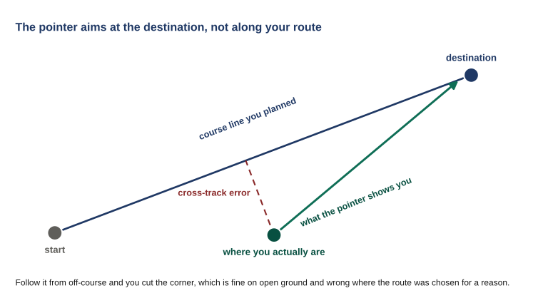
A start point and destination joined by a planned course line, with the traveler off to one side, an arrow aiming straight at the destination, and the perpendicular cross-track distance marked.

Figure 4.1 Cross-track error is the number that tells you how far you have drifted from the line you chose. The pointer will not mention it, so if the route mattered, that is the figure to put on screen.

Most devices can also show your relationship to the original course line rather than just the direction to the destination. That distance to the side of your planned line is cross-track error, and it is the number that tells you whether you have drifted off a route you chose deliberately. If the route mattered — because of terrain, because of a hazard, because somebody else is walking it too — cross-track is the number to watch, not bearing.

Knowledge Check

A member is following the navigation pointer to a point 800 meters away and reports being 800 meters out. What has to be true for that report to be useful to somebody planning around it?


3. Recording a position worth keeping

There are two different reasons to record a position, and they deserve different amounts of effort.

Marking on the move is what you do when something matters and you are not stopping: a vehicle, a blocked route, a casualty collection point, a track junction. One press, keep walking, fix the name later. The position is worth whatever the fix was worth at that instant, which is usually fine.

Recording a fixed site is different. A cache, a rally point, a water source, a helicopter landing site — somewhere a person will have to find in the dark, possibly on somebody else’s directions, possibly months later. That deserves a better position than one press gives you, and the tool for it is position averaging.

What averaging actually does, and what it needs

Averaging takes repeated fixes at the same spot and combines them, on the reasoning that random error falls on all sides of the truth and cancels out with enough samples. That reasoning is sound. The catch is the word random.

Two fixes taken thirty seconds apart are computed from very nearly the same satellites in very nearly the same positions in the sky, with the same atmosphere in the way and, if you are near a rock face, the same reflection arriving. Their errors are not independent — they are almost the same error twice. Average fourteen of them and you have carefully computed the average of one error, which is that error.
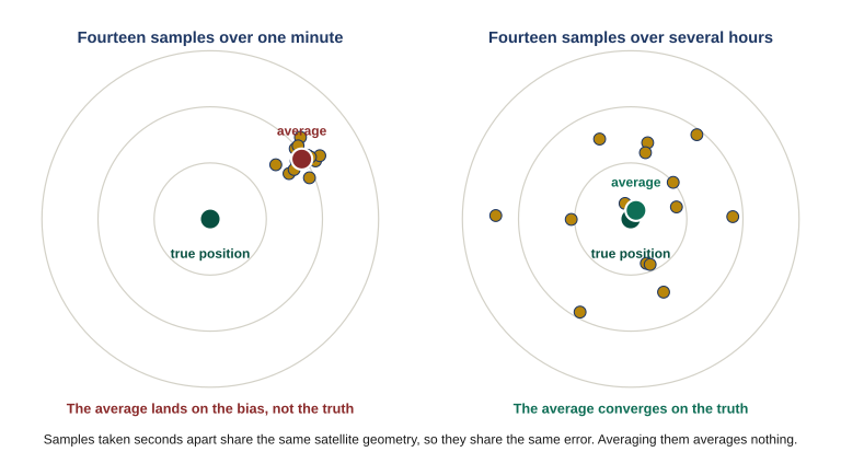
Two scatter plots of sample fixes around a true position: a tight cluster offset to one side, and a wide spread centered on the truth.

Figure 4.2 Fourteen samples taken inside a minute share the same satellite geometry, so they share the same error and their average lands on the bias rather than the truth. Fourteen taken over several hours see the geometry change, fall on different sides, and converge. Averaging only removes error that differs between samples.

Getting genuinely independent samples means letting the geometry change, and the geometry changes on the satellites’ schedule rather than yours. Manufacturer guidance is consistent on this and more demanding than most people expect: collect four to eight samples, with at least ninety minutes between them. That turns a cache position into an afternoon rather than a minute — which is the honest cost, and worth paying exactly once for a site you will rely on for years.

The thirty-second average

Standing still and letting the device average for thirty seconds feels like diligence and produces a number with more decimal places, which makes it feel earned. It is not. It smooths the jitter and leaves every systematic error exactly where it was, while handing you a result that looks more trustworthy than the single fix you started with.

If you do not have the time to do it properly, take a single fix and record it as a single fix. A position you know is rough gets treated as rough. A position that is rough but looks precise gets acted on.

Knowledge Check

Why does averaging a position require samples separated by long intervals rather than a burst of readings in one sitting?


4. Reading the accuracy figure in the field

Lesson 01 established what the accuracy number is: the receiver’s estimate of its own work, honest within its own terms and blind to the errors it cannot detect. Here is how that translates into action.

Use it as a relative signal, not an absolute one. Its most useful property is how it changes. A figure that climbs as you enter a drainage is telling you something real about the drainage. A figure that is unchanged while your plotted position jumps around is telling you the device does not understand what is happening to it — which is more informative than the number itself.

Compare it against what you are about to do with the position. Marking a vehicle you will walk back to in daylight, almost any figure will do. Passing a grid that somebody will fly a helicopter to, or recording a cache you will look for at night, and the same figure is not remotely good enough. The number does not change; the standard you hold it to does.

Never let it substitute for looking at the ground. A healthy accuracy figure and a wrong position coexist comfortably, and every one of the settings failures from Lesson 03 produces exactly that combination. The figure is one input. The terrain in front of you is the other, and Lesson 06 is where the two get formally reconciled.

Knowledge Check

Which observation about the accuracy figure carries the most information for a member in the field?


5. Naming, briefly

Every position you save gets a name, and the device will happily supply one like 017. That is fine for a mark you will use in the next twenty minutes and useless for anything else — particularly for anything another member has to find in a list on a dark screen.

A workable name says what the thing is and where, in a form that sorts sensibly: purpose first, then a short locator. The full naming convention is a group decision and it belongs with routes, so Lesson 05 sets it properly. For now, the rule is simply that a default number is not a name, and renaming is easier standing still now than searching later.

What to carry out of this lesson

  • Read a position back off the device and have the sender confirm it. Checking your typing against the paper you copied from reproduces your own error.
  • The pointer answers “which way is it from here,” not “which way should I go.” The distance it shows is straight-line, not walking.
  • Averaging only removes error that differs between samples. Four to eight samples, ninety minutes apart, or record it honestly as a single fix.
  • The most informative thing the accuracy figure does is fail to react while the position moves.
Field Drill

All four parts on real ground with the device you carry.

  1. Have somebody read you a position out loud from a map, in a format you did not choose. Enter it running the five steps above, out loud, including the read-back. Note where in the sequence you wanted to cut a corner.
  2. Navigate to a point roughly a kilometer away across ground that is not flat and open. Before you start, write down what you think the walk will be. Compare that against the straight-line distance the device reports, and against how long it actually takes.
  3. Pick a site you would genuinely cache something at. Take a single fix and write it down. Then take a second fix at the same spot at least ninety minutes later and write that down too. Measure how far apart they are. That distance is the error you were about to accept.
  4. Look through the saved positions already on your device. Count how many you could identify from the name alone, without opening them.

Keep the results with the sheets from Lessons 01 through 03.

Answer all four knowledge checks to unlock Lesson 05
← Lesson 03: Device Selection and Configuration

Login with Patreon

Login with Patreon

Search Site

Products

  • Family Emergency Plan and Household Recovery Workbooks - Patreon Family Emergency Plan and Household Recovery Workbooks - Patreon $34.95
  • Bundle - Family Emergency Plan and Household Recovery Workbooks Bundle - Family Emergency Plan and Household Recovery Workbooks $46.95
  • Household Recovery Workbook Household Recovery Workbook $29.95
  • The Continuity Chronicles Seal Decal The Continuity Chronicles Seal Decal $5.00 Original price was: $5.00.$3.00Current price is: $3.00.
  • Family Emergency Plan Workbook - Patreon Family Emergency Plan Workbook - Patreon $19.95
  • Personal Preparedness Assessment Workbook - Patreon Personal Preparedness Assessment Workbook - Patreon $19.95
  • The Next of Kin Workbook - Patreon The Next of Kin Workbook - Patreon $23.95
  • Personal Preparedness Assessment Report Personal Preparedness Assessment Report $179.95
  • Bundle - Family Emergency Plan + Next of Kin Workbooks Bundle - Family Emergency Plan + Next of Kin Workbooks $49.95
  • The Next of Kin Workbook The Next of Kin Workbook $29.95
  • ASAR — 50 Mile Radius ASAR — 50 Mile Radius $139.95
  • ASAR 50-MILE + FEP WORKBOOK ASAR 50-MILE + FEP WORKBOOK $169.95
  • ASAR — 50 Mile Radius - Patreon ASAR — 50 Mile Radius - Patreon $39.95
  • Bundle - The Series Starter (Paperback) Bundle - The Series Starter (Paperback) $29.98
  • The Brush (Paperback) The Brush (Paperback) $15.99
  • The Meadow Protocol (Paperback) The Meadow Protocol (Paperback) $13.99
  • Cards (4x6) - Brevity Cards for OTP Cards (4x6) - Brevity Cards for OTP $24.95
  • Communications Card bundle (13 cards) Communications Card bundle (13 cards) $41.95
  • Personal Preparedness Assessment Workbook Personal Preparedness Assessment Workbook $24.95
  • Family Emergency Plan Workbook Family Emergency Plan Workbook $24.95

Product categories

Cart

©2026 Fortune Favors the Prepared | Built using WordPress and Responsive Blogily theme by Superb