NAV-06 · Lesson 01
What GPS Is, and How It Fails
Why a device reporting three meters of accuracy can still put you in the wrong drainage.
Reading: about 15 minutes · Field drill: about 30 minutes
A GPS receiver does not know where it is. It calculates where it probably is, from timing signals it has no independent way to check, and then reports a confidence figure that it generated itself. That calculation is correct the overwhelming majority of the time, which is exactly what makes the remaining cases dangerous: a wrong fix looks identical to a right one.
This lesson covers how a fix is computed, four conditions that routinely degrade one, and where the device belongs in a navigation PACE plan. Nothing here requires you to touch a device. It exists so that everything you do to a device in the next nine lessons is done for a reason.
1. A fix is a calculation, not an observation
Every satellite in a GNSS constellation does one thing continuously: it broadcasts a message saying, in effect, this is who I am, this is exactly where I am, and this is exactly what time it is right now. It knows the time to within billionths of a second, because it carries an atomic clock. Your receiver picks up that message, compares the timestamp inside it against the moment the message arrived, and multiplies the difference by the speed of light. The result is a range — a distance from you to that satellite.
One range places you somewhere on the surface of an enormous sphere centered on that satellite. A second range narrows you to the circle where two spheres intersect. A third narrows you to two points, one of which is out in space or deep underground and can be thrown away. That is trilateration, and it is the whole idea.
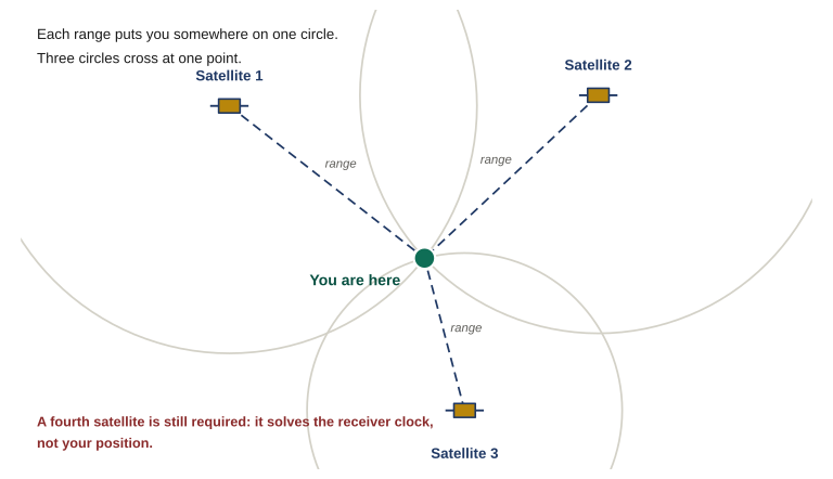
Figure 1.1 Three ranges narrow you to one point, which is why trilateration is usually described as needing three satellites. It needs four. The arithmetic assumes the receiver knows the exact time, and it does not — so the receiver’s own clock error is solved as a fourth unknown alongside latitude, longitude and altitude.
Which raises an obvious question: if three ranges are enough, why will no receiver report a position until it has four satellites?
Because the arithmetic above assumes your receiver knows the exact time, and it does not. Your device keeps time with an inexpensive quartz oscillator, not an atomic clock. A timing error of one millionth of a second — a microsecond, a rounding error by any ordinary standard — produces a range error of roughly 300 meters. Putting an atomic clock in a handheld is not an option, so receivers do something cleverer: they treat their own clock offset as a fourth unknown and solve for it at the same time as latitude, longitude, and altitude. Four unknowns need four equations, and each satellite supplies one.
The consequence matters more than the mechanism. Your position is the solution to a system of equations, not something the device looked at and saw. Feed that system slightly wrong inputs and it does not stop, throw an error, or go blank. It produces a slightly wrong answer, displayed with exactly the same confidence as a correct one. Everything else in this lesson follows from that.
2. The accuracy figure is the device’s estimate of its own work
Somewhere on your device is a number reading something like Accuracy: 4 m. Learn to read it correctly, because nearly everyone reads it as a guarantee and it is not one. Manufacturers label it differently — estimated position error, position accuracy, position error, or simply accuracy — and in every version the operative word is estimated.
The receiver computes that figure from two things it can genuinely measure: the geometry of the satellites it is currently tracking, and the strength and quality of the signals arriving from them. Good spread across the sky and strong, clean signals produce a small number. Clustered satellites and weak signals produce a larger one. Within its own terms, the estimate is honest work.
The problem is the class of error it cannot see. Suppose a signal reaches you not directly but after bouncing off a wet rock face fifty meters away. It arrives strong. It arrives clean. Its timestamp is valid and uncorrupted. It simply arrives late, because it traveled farther — and the receiver has no means whatsoever of knowing it took the long way around. That inflated range goes into the solution as though it were direct, your plotted position shifts, and the accuracy figure does not move, because from the receiver’s point of view nothing about that signal looked wrong.
Read the accuracy figure as a floor on plausible error, never as a ceiling on actual error. A small number means conditions look good for the errors the device is able to detect. It says nothing about the ones it cannot.
3. Four conditions that degrade a fix
Four conditions account for most of the bad fixes a member will meet in the field. Learn the situation that produces each one, because in almost every case you can predict a degraded fix from the ground you are standing on before the device tells you anything at all.
Satellite geometry
Accuracy depends less on how many satellites you are tracking than on how they are spread across the sky. Satellites low and clustered in one quarter of the sky intersect at shallow angles, and shallow angles smear the solution into a long, thin error ellipse. Satellites spread evenly, some high and some low, cut it down tightly. Receivers express this as DOP, dilution of precision, often split into horizontal and vertical components. You do not control it directly, but terrain does: a narrow valley, a steep face, or a street between tall buildings leaves you a strip of visible sky and therefore a clustered set of satellites.
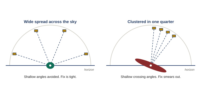
Figure 1.2 Accuracy depends on how the satellites are spread, not on how many there are. Wide spacing gives steep crossing angles and a tight fix. Satellites clustered in one quarter of the sky cross at shallow angles and smear the solution into a long, thin ellipse. Terrain decides which of these you get.
Multipath
A signal that reflects off rock, water, wet ground, a building face, or a vehicle before reaching you has traveled farther than the direct path, and the receiver reads that extra travel as extra distance. Urban ground is the worst case, which is why NAV-04 carries this problem further. Heavy wet canopy is the second. Multipath produces the specific, memorable symptom of a position that wanders or jumps by tens of meters while you stand perfectly still.
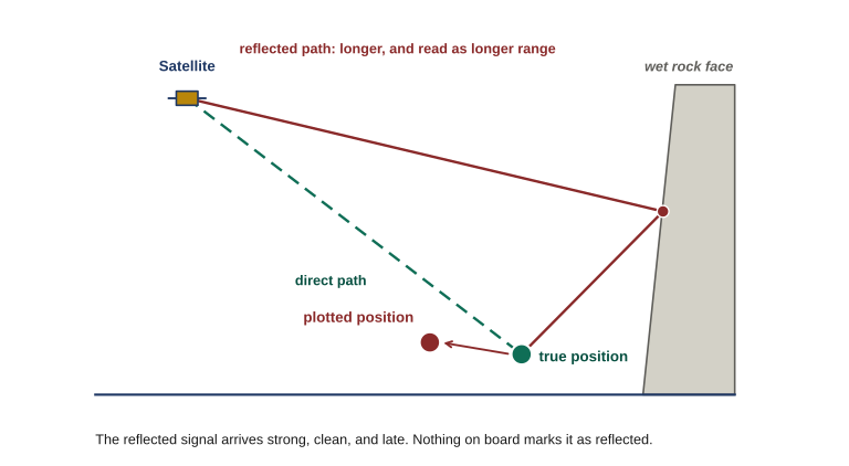
Figure 1.3 A signal that reflects off rock before reaching you has traveled farther, and the receiver reads that extra travel as extra range — which shifts the plotted position away from where you are standing. The reflected signal arrives strong, clean and late, and nothing on board marks it as reflected.
Cold starts and stale orbital data
To use a satellite, a receiver needs current data describing where that satellite actually is, and it collects that data from the satellites themselves, slowly. A device that has sat in storage for months, has traveled several hundred miles since it was last switched on, or has had its batteries out will need to gather it again. Expect a long first fix — minutes rather than seconds — and treat the first positions offered with suspicion. The fix worth having is the one taken after the device settles.
Vertical error
Elevation is the weakest number your device produces. Every satellite you are tracking sits above you and none sit below you, so the geometry that constrains your horizontal position well constrains your height poorly. As a working rule, vertical error runs somewhere between one and a half and three times the horizontal error on the same fix. A device claiming five meters horizontally may be off by fifteen vertically — enough to place you on the wrong bench, the wrong terrace, or the wrong side of a saddle.
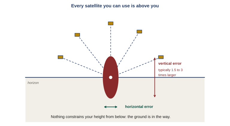
Figure 1.4 Every satellite you can use sits above the horizon and none sit below it, so nothing constrains your height from underneath. Vertical error typically runs one and a half to three times the horizontal error on the same fix — a device claiming five meters horizontally may be fifteen meters out on elevation.
| Condition | Where to expect it | What the device tends to show |
|---|---|---|
| Satellite geometry | Narrow valleys, steep faces, streets between tall buildings, dense canopy | Position stays put; accuracy figure climbs and stays high; improves gradually |
| Multipath | Urban ground, wet rock, standing water, metal structures, vehicles | Position jumps while you are stationary; accuracy figure may look normal throughout |
| Cold start | First use after storage, battery change, or long-distance travel | Very slow first fix; early positions unstable, then settle |
| Vertical error | Every fix, always, everywhere | Elevation readout looks as confident as the grid does, and is not |
Two of these fail in visibly different ways, and telling them apart in the field is worth more than either definition. Poor geometry degrades a fix steadily: the position holds still, the accuracy figure climbs and stays elevated, and things improve gradually as satellites move or you reach more open sky. Multipath degrades a fix erratically: the position jumps while you are stationary, the accuracy figure may look fine the whole time, and the behavior changes second to second as the reflection geometry changes. Steady and pessimistic is geometry. Jumpy and confident is multipath.
4. Where the device belongs: GPS in a PACE plan
PACE stands for primary, alternate, contingency, emergency. It is a planning habit borrowed from communications, and it transfers to navigation cleanly: you decide in advance, standing somewhere comfortable where thinking is easy, what you will do when your first choice stops working.
For most members the legs run something like this:
Two things about that list are easy to misread.
The first is that an alternate leg built from the same equipment is not an alternate leg. A phone and a handheld both drawing on the same power bank fail together the moment the power bank does, and a second device with no maps loaded is a paperweight the moment you lose signal. Independence is the entire point of the leg.
The second is the more important one, and it is the argument this course is built around.
Stepping down a leg is not triggered by the device failing. It is triggered by the device and the ground disagreeing. A dead device announces itself and needs no plan; the case that gets people hurt is the device that is still on, still bright, still claiming four meters, and wrong — because it is being fed reflected signals off a canyon wall, or because someone changed a setting three weeks ago and nobody checked. That failure is silent by construction. The only thing that surfaces it is a member who compares the fix against the ground and notices they do not agree.
Which is why the framing for this course is deliberately blunt: GPS is the primary, and map and compass is the emergency. The device is faster and more precise than a paper map, right up until it is neither — and a member who cannot check a fix against terrain has no way of knowing which of those two situations they are currently in. That check is the subject of Lesson 6, and it is the skill this entire course exists to build.
5. What the rest of this course does
Lesson 2 covers what is actually overhead: four independent satellite systems, and the two separate receiver capabilities that people routinely confuse with each other. Lesson 3 covers device selection and the settings that decide whether a coordinate is usable at all — map datum, coordinate format, north reference. It is the highest-value lesson in the course, because a datum or format mismatch is the most common way a perfectly correct coordinate puts a member hundreds of meters off the mark. Lesson 4 covers core operations and Lesson 5 covers planned routes, recorded tracks, and retracing your own path back out. Lesson 6 is the core of the course: transferring coordinates between device and paper map, and the decision rule for what to do when the two disagree. Lessons 7 through 9 cover reporting a position, device OPSEC, and operating when the signal is degraded or gone. Lesson 10 sets the group standard and puts all of it on the ground.
None of it changes the conclusion you should already be carrying out of this lesson: the device produces a claim, and a claim is something you check.
- A fix is a calculation from timing signals, not an observation. Feed it slightly wrong inputs and it produces a slightly wrong answer with the same confidence as a right one.
- The accuracy figure is the receiver’s estimate of its own work. Treat it as a floor on plausible error, never a ceiling on actual error.
- Geometry degrades a fix steadily; multipath degrades it erratically. Steady and pessimistic is geometry, jumpy and confident is multipath.
- The trigger for stepping down a PACE leg is not the device failing. It is the device and the ground disagreeing.
Name the ground you actually operate on — the area around your home, your commute, the property you would move to, the nearest public land you use. Then, on paper:
- Identify which of the four conditions from Section 3 is most likely to degrade a fix there, and name what specifically about that ground causes it.
- Write down what you would expect to see on the device when it happens: position steady or jumping, accuracy figure elevated or normal.
- Write out your four PACE legs for that ground, naming equipment you actually own. If your alternate leg shares batteries with your primary, or has no offline maps on it, fix that before you start Lesson 3.
Keep this sheet. Lesson 10 returns to it when you build the group standard.
| ← NAV-06 Course Map |